Forecast for the Salt Lake Area Mountains

Drew Hardesty
Issued by Drew Hardesty for
Tuesday, November 27, 2018
Patience is the name of the game. A CONSIDERABLE danger exists for human triggered avalanches 1-3' deep on the northern half of the compass at the mid and upper elevations. The danger is more pockety on westerly and southeasterly aspects, but no less dangerous. Remember these avalanches may be triggered from adjacent slopes or from the flats below. We may see a developing wind drift or two at the higher elevations in the afternoon.
Hot Tip! Low Risk High Reward skiing and riding conditions on shady 30° and less slopes with nothing steep above.
Low
Moderate
Considerable
High
Extreme
Learn how to read the forecast here
Special Announcements
Little Cottonwood Canyon will be closed this morning as the UDOT avalanche teams sight-in their artillery for the winter season. Backcountry closures are in effect with an estimated opening of 8am.
Alta Ski Area would remind folks that while the summer road to Catherine's is open, the Supreme area is closed to backcountry traffic as they conduct avalanche mitigation in order to open this terrain. Thanks -
Weather and Snow
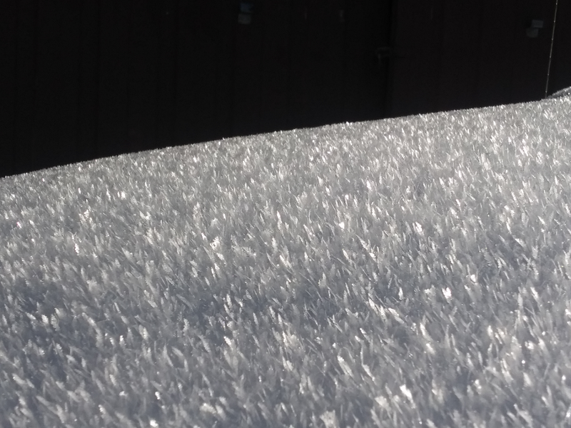
Skies are overcast this morning with light to moderate westerly winds. Mountain temperatures are already in the upper 20s to low 30s. The Thanksgiving storms were a godsend and we now finally have a base of snow to work with. One to three feet of snow exists in the mid to upper elevations with excellent, if tentative, riding in the soft settled powder from the weekend. Surface hoar now glitters upon the snow surface in most areas, capping the weakening snow surfaces on the shady side of the compass . Sunny slopes will be crusted over this morning. (Surface Hoar pc: Keating. These are on plus-size feathers; whereas most are roughly 2-4mm)
Looking down the road, we'll see a series of weak westerly waves which should produce a trace to a couple inches of snow every day or so with a more potent storm on tap for Thursday night and perhaps again over the weekend. The later storms may be a central Wasatch special benefiting our forecaster Brett Kobernik down on the Skyline. Of equal importance is whether these skiffs of new snow will gently preserve the surface weaknesses we've developed over the past few days. This may cause headaches for our snowpack down the road.
For today, we'll have mostly cloudy to overcast skies, increasing-to-20mph westerly winds along the ridgetops, and mountain temps in the upper 30s.
Recent Avalanches
Avalanche activity slowed down a touch yesterday and I attribute this to slow stabilization of the snowpack as well as fewer triggers (ie- you, the gentle backcountry traveler). Many ski area control teams and backcountry folks described things as being less sensitive and more stubborn...yet it's my opinion that this trend leads to more accidents and not less. More on this later. First, the activity:
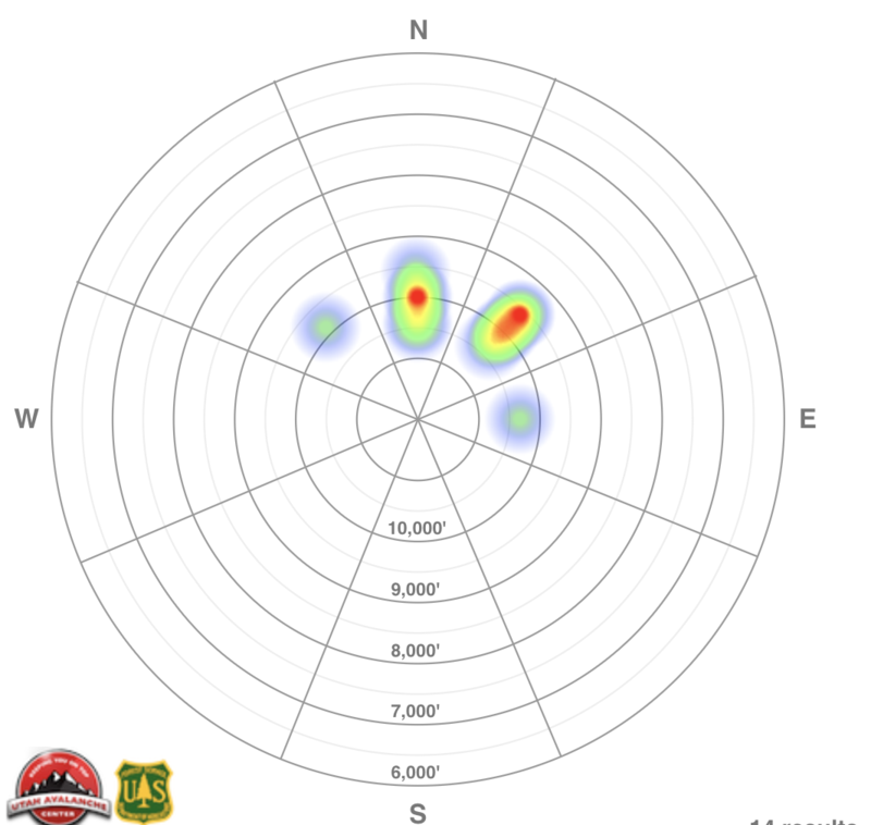
  • Wolverine Cirque: 10,500' East facing: two remotely triggered pockets 18" deep and 20' wide.
  • Park City ridgeline southern end: 9800' North facing: skier remotely triggered avalanche 2-3' deep failing on facets above the October crust.
  • Park City ridgeline central section: 9600' Northeast facing: skier remotely triggered avalanche 1.5' deep and 200' wide. (pc: Young)
Ad
Avalanche Problem #1
Persistent Weak Layer
Type
Location
Likelihood
Size
Description
The "heat map" below is a rough aggregate of reported backcountry avalanche activity over the last several days. It certainly matches our mapping of where the old, rotten pre-existing snow remained from the October storms. This structure was just waiting for a storm to develop an overlying slab. Greg Gagne put together a mind-blowing before/after map of the Meadow Chutes of Silver Fork with some cool technology here. It's worth a look-see.
While things may have been a bit more stubborn yesterday, cracking and collapsing remained the rule and not the exception. All the Bull's Eye clues to dangerous avalanche conditions however, remain present. It's enough to continue to avoid steep slopes with an eye toward what's above you. These avalanches may still be triggered from adjacent slopes or below.
Avalanche Problem #2
Normal Caution
Type
Location
Likelihood
Size
Description
The lower elevations and sunny slopes that were bare ground before Thanksgiving have one to two feet of new snow sitting on dirt and rocks, and a low avalanche danger. Use normal caution - hitting rocks and stumps remains the greatest hazard.
Watch for a few developing wind slabs along the higher elevations. These may be surprisingly sensitive in localized terrain, more prominently on steep slopes with an easterly component.
Additional Information
The researcher Robin Hogarth and others coined the term "Wicked Environment" to describe situations where feedback can be misleading, even deadly. In the backcountry, we're entering into a wicked environment where we might start to nibble around a few slopes or even ski or ride some and GET AWAY WITH IT. Until we don't. Remember the odds. When we commit to being on or beneath a steep slope, we can't be wrong. Being right 90% of the time will get you and A in math class, but it'll get you injured in the backcountry.