UDOT PLANNED AVALANCHE CLOSURES!!

Forecast for the Salt Lake Area Mountains

Drew Hardesty
Issued by Drew Hardesty for
Wednesday, November 28, 2018
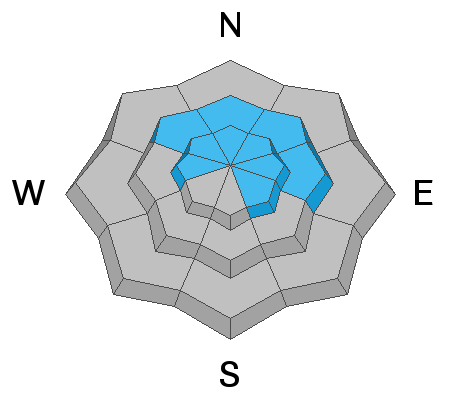
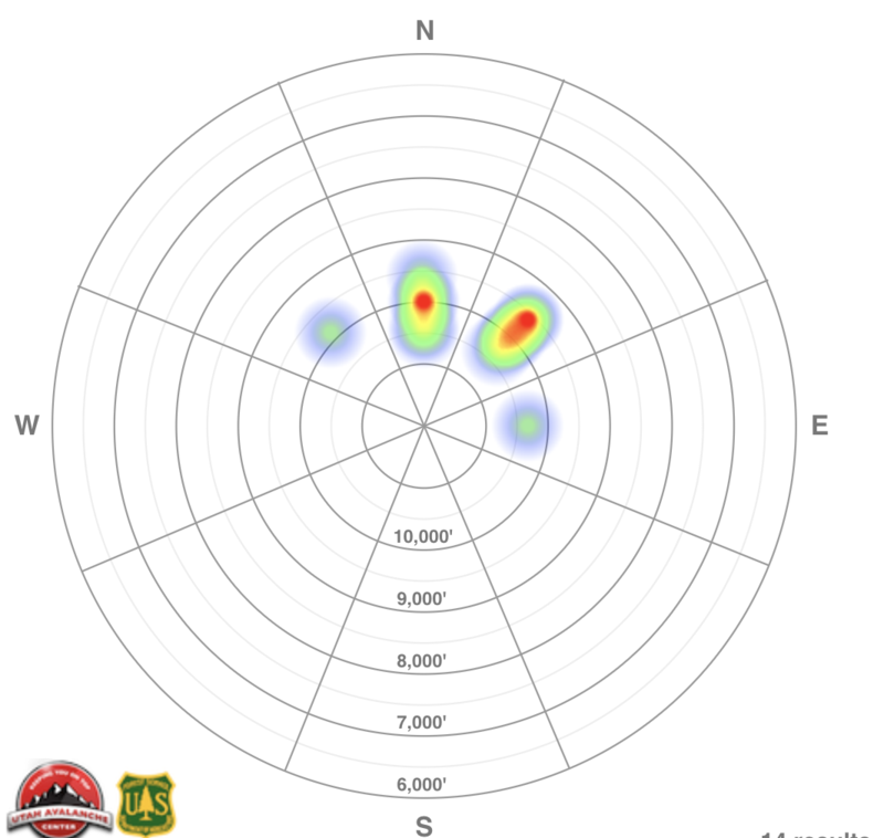
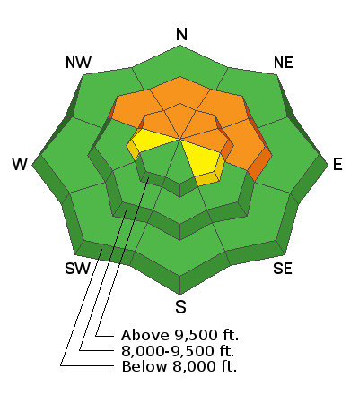
Areas of CONSIDERABLE danger exist for human triggered avalanches 1-3' deep on the northern half of the compass at the mid and upper elevations. The danger is more pockety on westerly and southeasterly aspects, but no less dangerous. Remember these avalanches may be triggered from adjacent slopes or from the flats below. Take care to avoid the thinly veiled rocks, stumps, and deadfall this early season.
Low
Moderate
Considerable
High
Extreme
Learn how to read the forecast here
Special Announcements
The 2nd Annual Ogden Backcountry Bash is coming up tomorrow November 29 at 6PM at The Front Climbing Gym in Ogden. Details here.
We have a couple of fun events coming up.
On December 5 at 7PM, join Andrew McLean and Greg Gagne at Rocksteady Bodyworks in Holladay for an open discussion of Recreating in a New Zone to learn about how the evaluate snow conditions when traveling and skiing in a new zone. Details here.
Or on December 5, head to the Salt Lake City REI, where Evelyn Lees and Pat Lambrose will be giving a free Women’s Avalanche Awareness talk. Talk starts at 6:30 pm. For more details and to reserve a spot for free, click here.
On December 6 at the Park City Library, Ascent Magazine presents The Slide Show a celebration of the coming of winter with video and photo presentations from some of the hardest working trail breakers around. Details here.

The UAC IOS App is not compatible with the new UAC website. We are working to release an updated version of the app as soon as possible. Please bear with us as we get the new app completed and released.
Weather and Snow
Skies are overcast with light snow falling in the mountains. Temperatures remain warm with overnight lows in the upper 20s to low 30s. Westerly winds hum at 10-15mph with gusts to 25. 1-3' of snow exists in the mid to upper elevations where you'll find soft settled powder on the north side of the compass with corrugated melt-freeze crusts on the south. Expect occasional snow showers this morning with perhaps another couple inches overnight. Thursday into Friday...continuing into early Saturday looks much more promising with perhaps a foot of more of new snow. Much colder for the weekend with mountain temps plummeting to the single digits.
Recent Avalanches
We heard of two avalanches triggered from a distance (ie: remotely triggered) yesterday in upper Little Cottonwood Canyon on northerly facing slopes in the upper elevations. One was triggered from a hundred feet away while traversing a very low angle slope. Cracking and collapsing remains general.
Ad
Avalanche Problem #1
Persistent Weak Layer
Type
Location
Likelihood
Size
Description
The "heat map" below is a rough aggregate of reported backcountry avalanche activity over the last several days. It certainly matches our mapping of where the old, rotten pre-existing snow remained from the October storms. This structure was just waiting for a storm to develop an overlying slab. Now we have it. Nat Grainger had a good observation yesterday from the PC ridgeline here. Overall, the slow trend is toward stabilization, but the travel advice remains the same. Best to avoid the steep west to north to southeast facing slopes.
Additional Information

Forecaster's Corner:
Clear, cold, and calm days are great days to be in the mountains but they're also the days that do the devil's business in the snowpack, particularly at and just below the snow surface. These were exactly the conditions during Sunday/Monday's high pressure (clear, cold, calm) that fostered the development of both surface hoar (wintertime equivalent of dew) and what we call diurnal recrystallized snow AKA near-surface faceting. Makes for great skiing and riding as the snow surface remains soft and turn-able, but problematic once buried. The question now lies in whether the pendulum has swung the other direction with the last 36 hours of warm, overcast, and some wind. Have the last 36 hours atmospheric conditions destroyed the surface hoar and rounded off the sharp edges from Sunday/Monday? Probably.
How to tell? Snow loupes can offer some insight into the evolution of the snow crystal metamorphism. Or simply being aware of the presence (or lack thereof) of surface hoar. When today's snow surface is slightly buried by a few inches of snow, the various shovel-tilt tests can reveal a lot.
Resources: Birkeland, Johnson, and Schmidt's seminal paper from the mid-90s on near surface faceting is very readable here.
How to Do a Shovel-Tilt test here.