Forecast for the Salt Lake Area Mountains

Trent Meisenheimer
Issued by Trent Meisenheimer for
Saturday, November 24, 2018
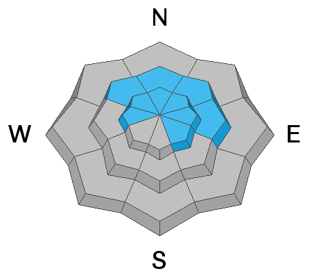
The avalanche danger is HIGH on slopes facing northwest through north through east at the upper elevations. Human-triggered and natural avalanches are certain. Travel in avalanche terrain is NOT recommended, including avalanche runout zones. Being involved in any avalanche will have significant consequences.
  • We will update this forecast by 7:30 Sunday morning.
Low
Moderate
Considerable
High
Extreme
Learn how to read the forecast here
Special Announcements
WITH STRONG WINDS AND NEW SNOW YOU CAN EXPECT RAPIDLY RISING AVALANCHE DANGER THROUGHOUT THE DAY.
Weather and Snow
A sharp cold front is on our door step this morning and will impact the mountains of northern Utah with strong wind and heavy snow throughout the day. Westerly winds are blowing hard across the upper elevations with speeds in the 20-30 mph gusting into the 40's & 50's. Overnight we picked up another 5-10" of new snow (0.50" to 1.50" h20). Current temperatures are in the mid 20's F° at the upper elevations and in the low 30's F° at 8500'. Once the storm arrives this morning the winds will shift from the west and become more northerly and increase with frontal passage. You can expect 9-16" of new snow today.
Recent Avalanches
There were a number of avalanches reported from the backcountry yesterday. Most were 8-10" deep and up to 150' wide, running into the flats. These avalanches all failed in weak faceted snow just above the October crust. During my field day in Day's Fork I had numerous loud collapses and shooting cracks up to 300' wide.
Photo: Mark White, Park City ridge line. You can read Mark's observation here, and look at all recent observations here.
Ad
Avalanche Problem #1
Persistent Weak Layer
Type
Location
Likelihood
Size
Description
Very weak faceted snow is preserved at mid and upper elevations that face west through southeast. This very loose sugary snow will quickly become overloaded by the strong winds and heavy new snow. Natural and human triggered avalanches are certain and travel in avalanche terrain is NOT recommended.
On my field day yesterday, I experienced one of the scariest early season snowpacks that I've seen in recent years. I triggered a number of avalanches from the safety of the ridge and had four or five very large collapses followed by shooting cracks. All the signs are pointing to very dangerous conditions. Now is not the time to ride on these slopes that harbor old weak snow. Avalanches can be triggered from a distance and from the bottom of slopes. Avoid being in runout zones as well as being adjacent to any steep slopes. This old faceted snow will remain a dangerous weak layer all weekend and beyond.
Avalanche Problem #2
Wind Drifted Snow
Type
Location
Likelihood
Size
Description
Winds are currently nuking across the upper elevations with speeds of 20-30 mph gusting into the 50's. With 9-16" of new snow expected you can be certain to find drifts of wind blown snow on all aspects at the mid and upper elevations. If the snow looks pillowy, fat/rounded that's a wind drift. Avoid being on steep slopes with new drifts of wind blown snow. Depending on how fast the storm snow falls we could see a period of new snow avalanches that fail within the new storm snow, especially on the steeper terrain.