Forecast for the Salt Lake Area Mountains

Greg Gagne
Issued by Greg Gagne for
Friday, November 23, 2018
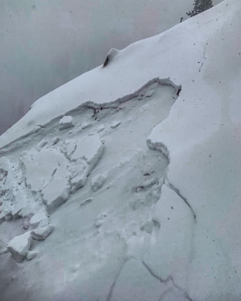
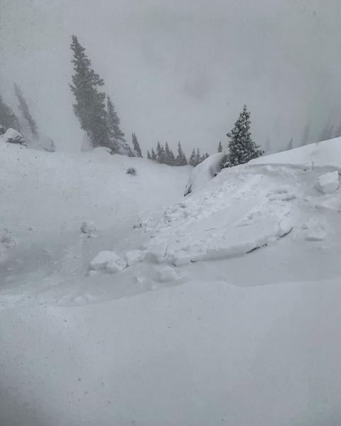
The avalanche danger is CONSIDERABLE on slopes facing west through southeast above about 9000'. Human-triggered avalanches are likely, and natural avalanches are possible. Being involved in any avalanche will have significant consequences as it will involve being carried over rocks, stumps, and downed timber. With more dense snow and strong winds in the forecast, the avalanche hazard will rise to HIGH by later tonight.
  • We will update this forecast by 7:30 Saturday morning.
Low
Moderate
Considerable
High
Extreme
Learn how to read the forecast here
Special Announcements
We are very proud to introduce our new website for the 2018-19 winter season. This will provide an easier and cleaner way to view all of the snow and avalanche information that you've come to rely on. We are quite happy with how the new website performs on mobile devices as well. We think you'll find the desktop or laptop experience pleasant as well. We are still tying up some loose ends so bear with us.
Link to video containing information about new website.
Check out our BLOG with even more info on our new web site and avalanche problems.
Weather and Snow
Mountain temperatures are in the 20's F this morning with west/southwest winds gusting in the teens and 20's mph at the mid elevations, and into the 40's at upper elevations. Snowfall totals since yesterday morning in the Salt Lake mountains are 6-10" with the higher amounts in Big Cottonwood Canyon. For today, we are expecting 3-6" of dense snow with increasingly strong westerly winds, averaging in the 20's and 30's mph at the mid and upper elevations, with stronger gusts approaching 50 mph at the upper elevations. Mountain temperatures will rise into the upper 20's and low 30's F, but the strong winds will likely make it feel much colder.
Recent Avalanches
Several natural and human-triggered avalanches were reported yesterday, especially during a period of high precipitation intensity in the early afternoon, when the avalanche danger spiked to High for a period. These slides were on northwest through east aspects above 9000' where the storm snow fell onto weak faceted snow. These avalanches were generally 6-8" thick, and up to 150' wide, failing at the layer of faceted snow at the old snow surface, with some breaking down to an older crust that formed in October. Photos below from Mark White in the Catherine's Pass area:
You can read Mark's observation here, and look at all recent observations here.
Ad
Avalanche Problem #1
Persistent Weak Layer
Type
Location
Likelihood
Size
Description
What really impressed me from my field outing yesterday afternoon was how sensitive the weak, pre-existing snowpack was to relatively modest snow and water amounts. Numerous bullseye clues were present: cracking, collapsing, and most importantly, natural and easily-triggered human avalanches. Our weak faceted snow preserved on mid and upper elevations facing west through southeast quickly showed its hand, and it was clearly telling us it was going to be very reactive to the load of new snow. The video below (LINK) describes our current snowpack on these slopes:
We can expect more avalanching on slopes harboring the weak faceted snow underneath, especially this afternoon as snowfall and winds increase. One final thought: although we generally think of northerly aspects as where we will find weak snow, the low angle of the November sun expands "northerly", making these early season weaknesses cover a pretty big piece of the compass on the problem locator rose.
This old faceted snow will remain a dangerous weak layer all weekend and beyond.
Additional Information
Strong winds and heavy snow overnight, followed by a sharp cold front and a classic northwest flow setting up for Saturday. By the time the storm winds down later Saturday, we can expect 2-3' of new snow. Clearing and colder Sunday, with strong warming into the early week. The good news is that we may be returning to an unsettled period again by later this coming week.
Snow coverage - and hence our options - are very limited – the “base” of 1 to 2 feet of old snow on shady slopes are becoming too dangerous to travel on, and it may not be until later Saturday until the southerly aspects fill in somewhat. In the mean time, our world-class resorts are opening and packed roads and low angle grassy meadows are backcountry options.