Forecast for the Salt Lake Area Mountains

Nikki Champion
Issued by Nikki Champion for
Thursday, November 10, 2022
Human triggered avalanches remain likely at upper elevations where soft slabs of new snow combined with fresh wind drifts are the main avalanche problems. In these places the avalanche danger is CONSIDERABLE. While conditions are slowly stabilizing, we still have enough uncertainty that it's worth being conservative today.

Mid-elevations generally had less wind and less snow, but human-triggered avalanches remain possible in the new snow, and the avalanche danger is MODERATE.
A LOW avalanche danger exists at all low elevations, where generally safe avalanche conditions exist.
Low
Moderate
Considerable
High
Extreme
Learn how to read the forecast here
Special Announcements
Many ski areas are now closed to uphill travel in order to prepare for winter operations. Resort uphill travel policies can be found HERE.
Mill Creek Canyon Road will be closed November 8-10th for road work.
Park City Mountain Resort is doing extensive control work along the Park City Ridgeline, including the 9990 zone, Mcconkey's and the Jupiter area. Please avoid resort terrain.
Weather and Snow
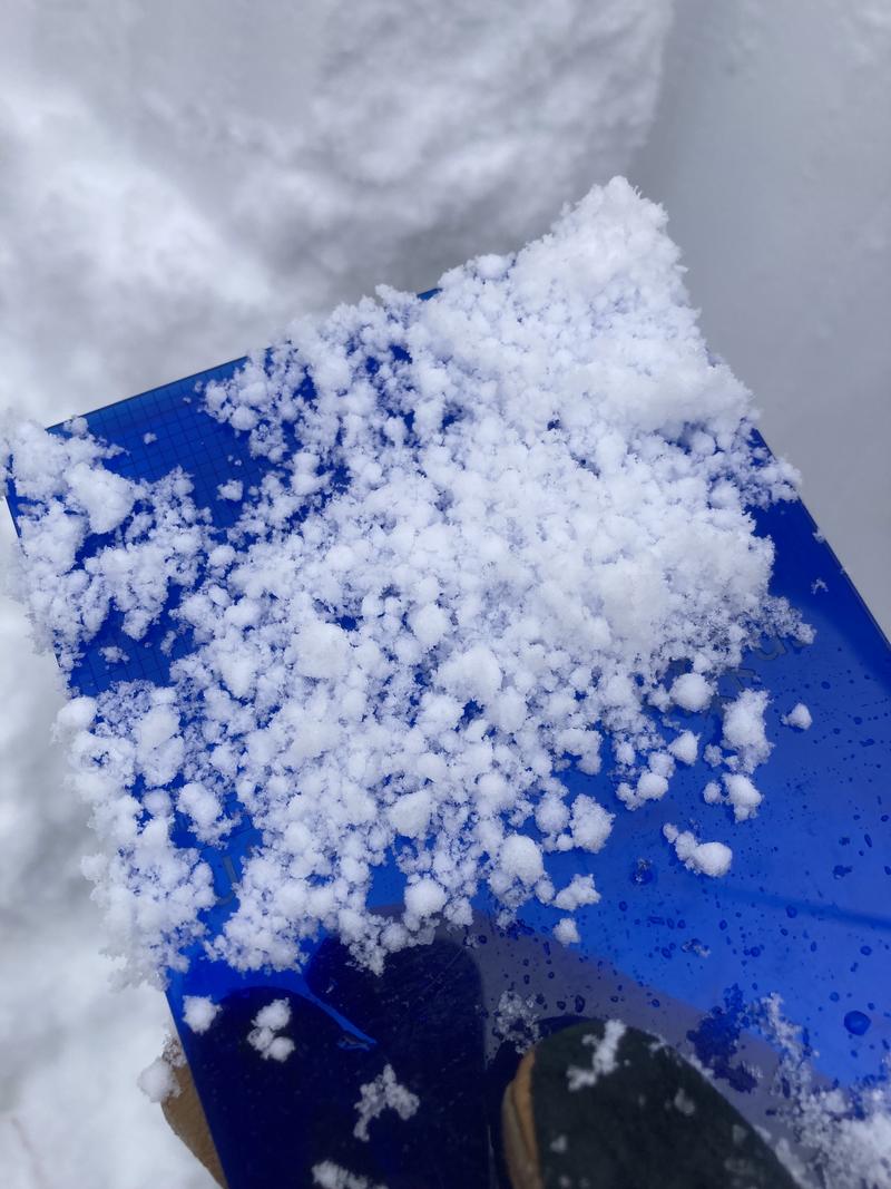
Snow: As of 5 a.m. an additional 3-5 inches of snow fell overnight and is still coming down. In the last 48 hours, the snowpack has more than doubled and most places have received dense, heavy snow containing 3 to 4.6 inches of water. Overall snow amounts vary a lot because of temperatures throughout the storm; however, above 9000 ft there is about 2-3 ft of new snow.
This morning, it is overcast and snowing lightly in the mountains. Temperatures are in the single digits to low teens F and winds are primarily from the west-northwest and moderate. Mid-elevation winds are averaging 5-15 mph with gusts near 25 mph. Upper-elevation winds are averaging in the mid-twenties with gusts near 35 mph. At the uppermost elevations, near 11,000', winds are averaging near 40 mph with gusts near 60 mph.
Today, the winter storm warning ends this morning at 11 AM. Snow showers will continue through the late morning before dry weather begins to move into the area. Temperatures will be in the upper teens F. Winds will remain moderate and west-northwesterly, gusting up to 45 mph at the highest elevations. Total accumulation today should be light, with another trace to 3" of snow.
Recent Avalanches
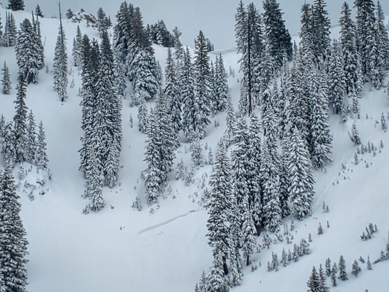
Yesterday, both natural and human-triggered avalanches were reported in the backcountry. These soft slab avalanches all failed 1-2' on the new snow, old snow interface, or density change within the storm. Check out the list of reported avalanches HERE.
Naturally triggered avalanche reported in West Bowl - Approx 18" deep and 70' wide. (Photo: S. Kuznetsov)
As well, an automated system from UDOT detected a few natural avalanches occurring in Little Cottonwood Canyon in the early morning hours and ski patrols were able to get some results throughout the day with explosives.
Ad
Avalanche Problem #1
Wind Drifted Snow
Type
Location
Likelihood
Size
Description
Throughout the storm, winds have remained strong enough to drift snow, with gusts near 60 mph at the highest ridgelines this morning. Today these drifts will be most widespread on south through east-facing slopes, especially at the highest most elevations. However, sustained high winds can deposit snow around terrain features on almost any aspect, called cross-loading. For this reason, I would expect to find sensitive slabs of wind-drifted snow at all upper-elevation and even some mid-elevation slopes, especially along with terrain features such as ridgelines, sub-ridges, and gullies.
As the winds continue to blow, these slabs will become more firm and more cohesive. This can allow you to travel out farther onto the slope before it breaks, and can fail larger and wider than expected. Approach each new drift with caution.
Today continue to look for slopes with any signs of wind-drifted snow, such as cracking, hollow noises, and pillow-shaped snow, and avoiding those slopes.
Travel Advice: Avoid wind-drifted terrain and avoid the problem, look for mid-elevation wind-sheltered terrain.
Avalanche Problem #2
New Snow
Type
Location
Likelihood
Size
Description
Overall, the new snowfall seems to be bonding well with the old, warm snow surface. That being said, there are still a few reasons I would be concerned about the new snow.
  • In areas that got overall higher precipitation totals, such as upper Big and Little Cottonwood Canyon, and are protected from the wind some sensitive storm snow may still exist. This could include both long-running sluffs, or shallow sensitive soft slabs.
  • Throughout the storm, there have been many periods of heavy graupel. This could allow for sensitive storm slabs to form atop of the pooled graupel. Graupel pooling may be founded beneath cliff bands and on slope transitions where graupel may pool deeply. These instabilities may be found on all aspects.
  • At low elevations, rain saturated the snowpack which now may have some amount of dry snow on top of it. Wet snow is not strong, and avalanches may break in that weaker wet snow.

Be especially thoughtful of this while traveling above terrain traps, cliff bands, and features in which the debris from even a shallow slab could pile up.
Stout layer of graupel within the snowpack from the beginning of the storm, obsvered in Mill D North. Find full observation HERE.
Additional Information
A Few Things to Remember:
  • Whether you're-hiking, hunting, skiing, boarding, snowshoeing or firing up the snowmachine, be prepared for avalanches
  • Any avalanche can produce serious trauma because of a thin snowpack
  • Hitting rocks and stumps is a real danger. Don't end your season early.
  • Treat ski resorts as backcountry terrain and check out the UAC site for resort uphill travel policies
General Announcements

This information does not apply to developed ski areas or highways where avalanche control is normally done. This forecast is from the U.S.D.A. Forest Service, which is solely responsible for its content. This forecast describes general avalanche conditions and local variations always occur.