Forecast for the Salt Lake Area Mountains

Drew Hardesty
Issued by Drew Hardesty for
Saturday, January 5, 2019
Today's avalanche danger is generally LOW. Pockets of new and developing wind drifts may be found in isolated terrain. The danger may reach MODERATE in some areas later today. Remember that risk is inherent in mountain travel - even a small avalanche can be significant in radical, no-fall terrain.

BIG PICTURE: The danger will be on the rise over the next several days and may reach HIGH in some areas. Stay tuned.
Low
Moderate
Considerable
High
Extreme
Learn how to read the forecast here
Weather and Snow
Greg's excellent - as usual - Week in Review can be found here on our blog page.

Skies are clear.
Mountain temps are in the mid to upper 20s.
The southwesterlies picked up and are blowing 20-25mph with gusts to 30. The most exposed anemometers have gusts into the 40s and 50s.
Skiing and riding conditions have been pretty good in the sheltered terrain, but that slice of pie is narrowing by the hour.
Total snow depths are 25-35" on the Park City ridgeline and about twice that in the Cottonwoods.

Two significant storm systems are on the doorstep. The first one arrives this evening with snow falling overnight into Sunday afternoon. Most areas can expect 6-12" of new snow. A warm front pushes the door down Sunday night into Monday with another round of denser snow with hourly wind speeds in the 45-55mph range. This may offer another 4-8", but this may be under-done. There are some hints that, for the combined storms, we may see upwards of 2" of snow-water-equivalent (perhaps translating to up to nearly 15-20"+ of snow) by late Monday.
Recent Avalanches
A few more wet loose sluffs noted in steep southerly terrain yesterday, but otherwise quiet.

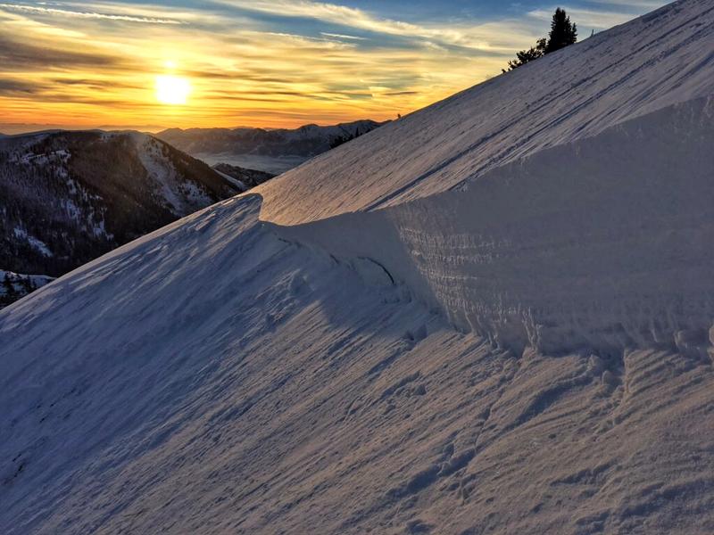
Three snowmobilers had a very close call in Providence Canyon up in the Logan area mountains yesterday and you can find more info on the Observations and Avalanches page. The avalanche was on a steep wind drifted south facing slope at 9000'. Logan forecaster Toby Weed spoke to the individuals and his photo is below. If you are one of of those Instagram people, you can find more on this @logan_avalanche_uac or on YouTube here.
Ad
Avalanche Problem #1
Normal Caution
Type
Location
Likelihood
Size
Description
The snow is mostly stable. The mountains have seen a fair bit of wind over the past week or so and much of it blew from the northwest, and north through east. The current winds, however, are from the south and southwest and while there isn't that much snow to blow around, there is some and shallow drifts may be found in isolated terrain today. I do think that incoming clouds and wind will keep the lid on any wet avalanche activity.

The last avalanches breaking into older snow layering likely occurred New Year's Eve during the wind event. These were in upper Hogum Fork of LCC on upper elevation northeasterly facing slopes that I would call extreme "non-skiable, non-rideable" terrain. (But I've been surprised by terrain choices before.) The Airplane Peak avalanches (roughly 2.5' deep and 80' wide were in thin, rocky areas that have likely avalanched previously this season. Not unlike, say, the northeast face of Lone Peak, the Salt Lake Twins....you get the idea.
Additional Information
General Announcements
This information does not apply to developed ski areas or highways where avalanche control is normally done. This forecast is from the U.S.D.A. Forest Service, which is solely responsible for its content. This forecast describes general avalanche conditions and local variations always occur.