Donate to the 2024 Spring Campaign to help rebuild the UAC website.

Forecast for the Salt Lake Area Mountains

Greg Gagne
Issued by Greg Gagne for
Sunday, January 6, 2019
The avalanche hazard is CONSIDERABLE on all aspects in open, exposed terrain above 9000' for wind drifted snow, particularly on aspects facing north, northeast, and east. Snowfall today may create sensitive storm slabs on all aspects at all elevations. On slopes below 9000' the hazard is MODERATE.
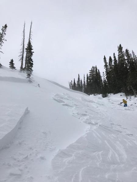
8 human-triggered avalanches were reported on Saturday, with one very close call. Let's make it zero today. The easiest recipe to enjoy today's storm snow is stick to low-angled, wind-sheltered terrain.
The hazard will be increasing as the day progresses, likely rising to HIGH by Monday morning.
Low
Moderate
Considerable
High
Extreme
Learn how to read the forecast here
Weather and Snow
For those looking to catch up on weather and avalanches conditions from this past week, read our Week in Review by clicking here.
Mountain temperatures are in the 20’s and winds are from the south and southwest and strong, with gusts in the 30’s and 40’s mph above about 9500’, and gusting in the 60’s mph at 11,000'
Overnight snowfall totals are 3-8”, with the highest amounts reported from Big Cottonwood Canyon.
For today’s weather, you can expect mountain temperatures in the 20’s with 4-8” additional snowfall. Winds will be from the southwest and west, gusting in the 20’s and 30’s above 9000’, with even stronger gusts at 11,000’
Recent Avalanches
There were 8 human-triggered avalanches reported from the backcountry on Saturday. These were all hard wind slabs, 6” to 24” thick and 25’ to 200’ wide. Some ran up to 350’ vertical. In 4 of the slides, at least one member of the party went for a ride, with injuries involved in 2 of the occurrences. These hard wind slabs were on slopes facing north, northeast, and east, aspects what we refer to as leeward as they were drifted from the windward south, southwest, and westerly winds. However, one slide was on a west aspect, indicating how terrain can channel winds and deposit fresh drifts on almost any aspect. These slides were all in large, open, exposed terrain, and generally above 9500', although one very close call on Blue Ice in Broads Fork (observation) was at 9000'.
Below is a photo from a slide in Maybird Gulch (pic Reed Sullivan)
You can read about all of the reported avalanche activity by clicking here. Thanks to everyone for their field reports from Saturday.
Ad
Avalanche Problem #1
Wind Drifted Snow
Type
Location
Likelihood
Size
Description
Saturday's very reactive, hard wind slabs are sitting on top of weak, faceted snow that formed on the pre-existing snow surface this past week, and they will remain sensitive at least through today. Some of the reported slides were triggered remotely, and at least a few broke above a rider, common themes with hard wind slabs on top of weak facets.
To complicate things, at least yesterday you could see them; these wind slabs are now buried by new storm snow, and winds today will create additional drifts.
Although the danger locator rose for this wind slab problem generously identifies wind slabs on all aspects at the mid and upper elevations, I think you are especially likely to find recent and new wind slabs in exposed open terrain above 9000', particularly on slopes facing north, northeast, and east. The hard drifts that formed yesterday may even be a little more stubborn today, allowing you to get well out onto a slope before it fractures.
Avalanche Problem #2
New Snow
Type
Location
Likelihood
Size
Description
Dense snowfall overnight and today will create fresh storm slabs that may be reactive, especially during any period of higher precipitation intensity. Cold, clear weather this past week created very weak faceted snow at the old snow surface. This weak layer quickly showed its hand on Saturday as it was very reactive to the load of fresh wind drifts, and it may be just as reactive to storm snow overnight and into today. Watch for signs of reactive storm snow including cracking and sluffing.
Fortunately, today's dense snow should provide excellent riding conditions on wind-sheltered, low-angled terrain.
Avalanche Problem #3
Persistent Weak Layer
Type
Location
Likelihood
Size
Description
I do not not think we currently have put enough of a load to make the deep October facets found down near the ground to awaken, but by Monday additional wind and storm totals with upwards of 2" of water weight may be enough to make them reactive in isolated areas.
I'm currently more concerned about thinner snowpack areas, especially at the mid elevations, where cold, clear weather this past week allowed the thinner snowpack to weaken. Wind and storm slabs today may break down to these weak, mid-pack layers, creating potentially large avalanches. I think this concern will be increasingly likely on Monday if the weather forecast verifies.
Additional Information
Ice climbers: Sizable sluffs are likely to run on the north facing ice climbs in Little Cottonwood Canyon and Provo Canyon. Many of the Wasatch ice climbs are in avalanche run outs - be aware of what terrain is above you.
General Announcements
This information does not apply to developed ski areas or highways where avalanche control is normally done. This forecast is from the U.S.D.A. Forest Service, which is solely responsible for its content. This forecast describes general avalanche conditions and local variations always occur.