Forecast for the Salt Lake Area Mountains

Trent Meisenheimer
Issued by Trent Meisenheimer for
Tuesday, January 29, 2019
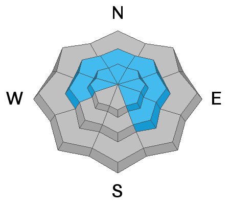
The avalanche danger is LOW on all aspects and elevations. However, there remains the chance for triggering a large, deep avalanche in isolated places. Avoid steep, shallow, rocky terrain at the upper elevations on west through southeast facing slopes. Continue to identify and avoid any of the rounded, smooth or scalloped wind drifts on any steep slopes. Keep in mind that even a small avalanche in dangerous terrain can be deadly.
Low
Moderate
Considerable
High
Extreme
Learn how to read the forecast here
Special Announcements
The report from Friday's avalanche accident is finished and can be found HERE. Our deepest condolences go out to the family and friends that are effected by this accident.
Weather and Snow
This morning we will see high clouds early in the day that should break up by the afternoon providing some sunshine. Temperatures took a dive overnight with many upper elevation thermometers reading in the teens °F. Lower in the canyons and valley bottoms the temperatures are in the single digits. Northerly winds finally calmed down after yesterday's weak storm system that passed over head. This morning the winds are from the northerly direction and are currently blowing 10-15 mph with gusts into the low 20's at upper elevations. Mid elevations, the winds are calm.
The northerly winds have done their work in the alpine creating sastrugi and wind board in many locations. Mid and low elevation shady terrain that is sheltered from the wind/sun provides soft settled powder. Southerly aspects will be crusted this morning and depending on cloud cover and your location they may or may not soften with day time heating.
Recent Avalanches
No new avalanches were reported from the backcountry. List of all backcountry observations can be found HERE.
Ad
Avalanche Problem #1
Wind Drifted Snow
Type
Location
Likelihood
Size
Description
Since January 21st we have seen multiple wind events with plenty of new snow to blow around. This has created new and old drifts of wind blown snow at the upper elevations and well down ridges into gullies and sub-ridges. However, these wind drifts and slabs have had time to adjust and gain strength and seem to be welded in place. For today, keep an eye out for new and old drifts of wind blown snow and avoid them. The good news, is these drifts should be easy to identify and easy to avoid. Keep in mind that even a small avalanche in dangerous terrain can be deadly and there remains the isolated chance that some of these drifts remain active.
Avalanche Problem #2
Persistent Weak Layer
Type
Location
Likelihood
Size
Description
If you take 20 mins and dig down 3-5' feet deep into the snowpack you can find a mid-pack layer of weak faceted snow. In some locations (like shallow areas) it's worse than other locations where the snowpack is much deeper. This layer is a concern because of the large slab of snow that sits on top of a relatively weaker layer of snow (strong over weak). Yes, this layer has been gaining strength and seems to be dormant and unreactive. However, we can't totally ignore the inherent poor structure of the snowpack in certain areas (see photo below). There still remains the isolated chance of triggering a slab avalanche in certain terrain.
The most likely location would be in a steep (greater than 35°degree), upper elevation, rocky slope that faces in the northerly direction (shady terrain). Especially, ones that been heavily wind loaded and therefore more stressed. This would be the terrain I would continue to avoid for now. It's the classic low-probability of triggering a high-consequence avalanche.
Photo: Mineral Fork 9,000' in elevation. This shows the strong snow over weaker snow set up we currently have in shallow snowpack zones. In this location the snow depth was 175 cm.
General Announcements
This information does not apply to developed ski areas or highways where avalanche control is normally done. This forecast is from the U.S.D.A. Forest Service, which is solely responsible for its content. This forecast describes general avalanche conditions and local variations always occur.