Join us at our 2nd Annual Blizzard Ball

Forecast for the Salt Lake Area Mountains

Drew Hardesty
Issued by Drew Hardesty on
Thursday morning, January 27, 2022
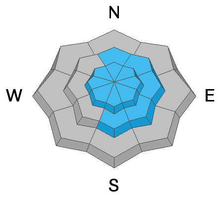
Areas of MODERATE danger exist in steep wind drifted terrain, primarily in the higher elevation bands. Any fresh wind drift should be avoided. Loose-dry snow (sluffing) can also be expected in steep northerly terrain.
Continue to maintain normal safe travel protocols of only exposing one person at a time to avalanche terrain. If you were to trigger a slide, your only hope of surviving will be having partners watching you from a safe location.
Low
Moderate
Considerable
High
Extreme
Learn how to read the forecast here
Special Announcements
Thanks to the generous support of our local resorts and Ski Utah, discount lift tickets are now available. Support the UAC while you ski at the resorts this season. Tickets are available here.
Weather and Snow
Another dry cold front is in the works and temperatures are dropping into the single digits and low teens. Skies, unfortunately, are clear. West to northwest winds picked up overnight and are blowing 15-20mph with the highest ridgelines holding court with hourly averages of 30-40mph with gusts to 50 and 60.
For today, we'll have mostly sunny skies, moderate north to northeast winds, and temperatures in the teens.
Riding conditions remain quite good in the wind and sun protected terrain.

We'll have sunny skies through the weekend, with temps warming again into the upper 20s and low 30s.
The weather models have long hinted at a pattern change as we move into February. It does appear that a storm arrives from the northwest Monday night and we should have a better handle of its progression in the coming days.
Recent Avalanches
A backcountry party yesterday reported a very large avalanche at 10,000' on the northeast side of White Baldy in upper White Pine that likely ran Tuesday some time. Details are unknown but estimates are that it was a few feet deep and a thousand feet wide. I suspect that an enormous natural cornice calved off from the ridgeline above and landed in just the right spot - steep, thin, rocky terrain - and triggered the avalanche.
***FORECASTER UPDATE: This slide occurred on or around Jan 6th.
Natural and human triggered loose snow "sluff" avalanches continue to be triggered in steep northerly terrain.
You can find all observations HERE.
Ad
Avalanche Problem #1
Wind Drifted Snow
Type
Location
Likelihood
Size
Description
Over the past couple of weeks, we've been nickled and dimed with a couple inches here, a couple inches there. Some of this snow has recrystallized into weak sugary faceted snow. Additionally, patches of surface hoar have - at times - been deposited on the snow surface in between these minor snowfall events.
The overnight and early morning winds are of concern. Fresh wind drifts may be found on all aspects but will be more relegated to upper elevation north to east to southeast facing terrain in the upper elevations. Pockets of wind drifts may also be found to the lee of very wind exposed ridgelines at the mid-elevations.
And so while there is not a lot of snow available for transport, there is some, and if traveling in the exposed or higher elevation terrain, be on the lookout for pockety and shallow, but sensitive wind drifts. They might just be big enough to bury a person in a terrain trap and certainly big enough to pose problems if caught in unforgiving terrain.
General Announcements
Who's up for some free avalanche training? Get a refresher, become better prepared for an upcoming avalanche class, or just boost your skills. Go to https://learn.kbyg.org/ and scroll down to Step 2 for a series of interactive online avalanche courses produced by the UAC.
This information does not apply to developed ski areas or highways where avalanche control is normally done. This forecast is from the U.S.D.A. Forest Service, which is solely responsible for its content. This forecast describes general avalanche conditions and local variations always occur.