Forecast for the Salt Lake Area Mountains

Evelyn Lees
Issued by Evelyn Lees for
Sunday, January 27, 2019
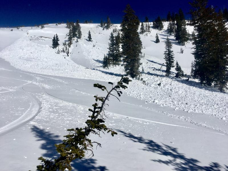
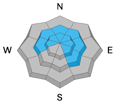
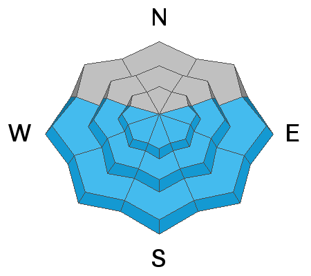
The Avalanche Danger is a scary MODERATE for triggering a large, deep avalanche in isolated places - on upper elevation slopes northwest through southeasterly. The danger is also MODERATE for triggering wind drifts at the upper elevations. But our snowpack is not simple, and not the same everywhere. Even in LOW DANGER TERRAIN avalanches can be triggered in very isolated places. Near ridge line and wind loaded, thinner snowpack areas are more suspect.
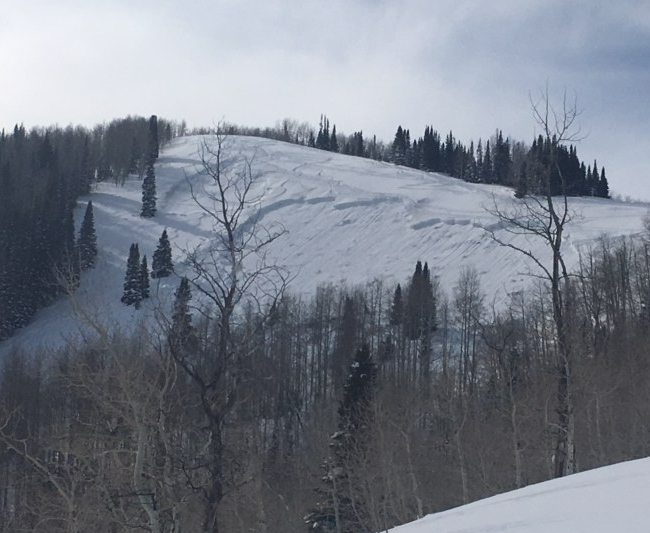
Wet Loose slides: the avalanche danger is LOW this morning while the snowpack is frozen, but may increase to MODERATE this afternoon if the snow become damp or wet where you are. This includes wet snow at the low elevations and avalanche run outs in the heat of the day.
Low
Moderate
Considerable
High
Extreme
Learn how to read the forecast here
Special Announcements
Two Utah men died in avalanches on Friday - Tommy Hawkins of Layton, Utah (snowmobiling near upper Palisades Lake, Idaho) and Scott Pehrson, of Monticello, UT (snowmobiling in the eastern La Sals, UT) We offer our deep sympathy to the family and friends of these two men. In Utah, a huge thanks to members from San Juan and Grand County Search and Rescues, Utah Department of Public Safety, Wasatch Powder Bird Guides and professional avalanche rescue dogs and handlers from Wasatch Backcountry Rescue, Alta, and Park City Ski areas who conducted recovery efforts.
Weather and Snow
Under partly cloudy skies, enjoy one of the quietest mornings in a while - the northwesterly winds have quieted to only 5 to 15 mph at most stations, with even the highest peaks only averaging 25 mph. Temperatures are in the mid teens to upper twenties this morning. A midst the wind damaged snow, there is very good dense, loose powder on shady wind sheltered slopes. Most southerlies will have breakable crusts this morning, softening later in the day.
Today, partly cloudy skies with temperatures warming into the upper 30s at 8000’ and upper 20s at 10000’. The northwesterly winds may once again increase this afternoon, especially along the high ridge lines, where averages of 30 to 40 mph, with gusts to 50 are possible. Speeds at the mid elevations should remain in the 5 to 15 mph range.
Recent Avalanches
Avalanche control teams continue to trigger large dangerous avalanches breaking in old snow (near) the ground with explosives. More stubborn, there were two triggered at 10,500' on southeast facing slopes. A few wet loose sluffs ran naturally on steep, south facing slopes in Little Cottonwood, at the mid elevations.
Slide on a southeast facing slope, at 10,500'.
Ad
Avalanche Problem #1
Wind Drifted Snow
Type
Location
Likelihood
Size
Description
The days of persistent northerly winds have done the most damage in the high alpine terrain. Slopes are wind stripped and wind loaded, and drifts can be found on almost any aspect - to the lee of ridge lines and cross-loaded into couloirs, gullies and mid slope break overs. The hard slabs of wind drifted snow may be stubborn, and the key is to identify and avoid any of the rounded, smooth or scalloped drifts on steep slopes, especially in unforgiving terrain, such as above cliffs and trees.
Winds cranking along Box Elder peak, blowing snow. Coyne photo.
Avalanche Problem #2
Persistent Weak Layer
Type
Location
Likelihood
Size
Description
It is not a simple snowpack, and there is lots of variation. The almost daily deep, upper elevation, explosive triggered slides mean there remains a low-probability of triggering a high-consequence avalanche breaking 2 to 5 feet deep on a sugary faceted weak layer. The most likely spot would be on an upper elevation, northwest through southeasterly facing slope, that is wind loaded over a rocky area with a shallower snowpack. Unsupported slopes above cliffs, steep rollovers, or very steep slopes are also more suspect. You may trigger one of these hard slabs when entering on the edges, where the snowpack is thinner.
In addition, the shallower mid elevation terrain, especially outside the upper Cottonwoods, has its own mid pack weakness and basal facets, like the recent slides on easterly facing slopes at 9,000’ on the Park City side show. This includes Snake Creek, upper American Fork, Grandview/Bountiful Sessions and Millcreek Canyon.
Photo below of Friday's large avalanche triggered in Homelight with just a single hand charge surface shot, prodding out a 3-5' deep and 500' wide deep slab on this east facing run at 9000'. Photo courtesy of PCMR snow safety.
Avalanche Problem #3
Wet Snow
Type
Location
Likelihood
Size
Description
Avalanche danger is LOW this morning for wet loose slides while the snowpack is frozen, but may increase to MODERATE this afternoon depending on the balance of clouds, wind and sun. If the snow where you are - on the sunny slopes or mid and low elevation shady slopes - gets soft and damp, roller balls start, or you can trigger small wet loose sluffs - it is time to get off of any steep slope with damp snow and out from under the steep, sunny slopes. Avoid travel in and below the bottom of steep, southerly facing gullies.
General Announcements
This information does not apply to developed ski areas or highways where avalanche control is normally done. This forecast is from the U.S.D.A. Forest Service, which is solely responsible for its content. This forecast describes general avalanche conditions and local variations always occur.