Join us at our 2nd Annual Blizzard Ball

Forecast for the Salt Lake Area Mountains

Dave Kelly
Issued by Dave Kelly on
Monday morning, January 20, 2025
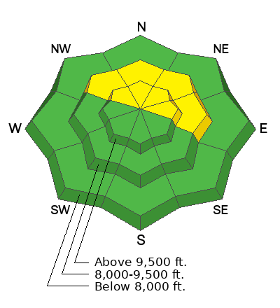
Today, there is a MODERATE avalanche danger for triggering an avalanche failing into the buried facets on mid and upper elevation northwest-north-east facing aspects. There is a LOW avalanche danger on all other aspects and elevations, where you may trigger a shallow wind-drifted snow avalanche.
The in-your-face nature of this avalanche problem is less apparent than it was even a few days ago. Special attention should be given to steep slopes that harbor weak faceted snow near the ground. Areas where you may trigger an avalanche 2'-4' deep will be thinner rockier zones and areas that avalanched during the holiday cycle and have been re-loaded with more wind and snow.
Low
Moderate
Considerable
High
Extreme
Learn how to read the forecast here
Special Announcements
Join the UAC at Deer Valley on January 30th for the 2nd Annual Blizzard Ball Gala. Former Director of the Utah Avalanche Center, Bruce Tremper will deliver the keynote address.
UAC forecaster Craig Gordon presents a FREE State of the Snowpack Presentation on Tuesday, January 21st from 6:00-7:30 PM at Alpha Coffee in Cottonwood Heights, get more information and reserve your spot HERE.
Weather and Snow
Currently under partly cloudy skies trailhead temperatures are in the low single digits °F, while the highest peaks are in the well below 0°F, with some readings as low as -11°F. Winds are blowing lightly from the northeast at the lower elevations and blowing from the north-northwest in the mid 20's gusting to the 30's at the highest ridgelines. Wind Chill is -37°F on the highest peaks, where any exposed skin can frostbite in under 10 minutes. Just to our north Peter Sinks, which is typically one of the colder locations in the Lower 48 is currently -23 °F.
Today, we should see partly cloudy skies this morning and sunny skies later this afternoon. Temperatures will rise to 8-12 °F and winds will blow lightly at the lower elevations from the northeast and from the north 25 gusting to 35 MPH at the highest elevations. With a northeast aspect to the winds there could be areas that see wind gusts up to 45 MPH. No new snow is expected today.
There was a trace of snow overnight, settled snow depths throughout the forecast region are 35"-82" and the cold temperatures have kept the snow surface soft. There is great travel to be had on 6"-10" of settled snow and the lower angle slopes (where you aren't feeling the crust) are still holding soft turns.
Recent Avalanches
Yesterday, we had no reports of avalanches from backcountry travelers. Ski areas are still getting results with explosives on steep north-east facing aspects and one local ski area reported an avalanche 6' deep x 75' wide that failed on the buried facets near the ground. The last reported avalanche failing on the buried facets was Thursday January 16, 2025 in Upper Big Cottonwood Canyon. We also had a report of a wind-drifted snow avalanche on Saturday January 18, 2025 in White Pine.
Read all observations HERE.
Ad
Avalanche Problem #1
Wind Drifted Snow
Type
Location
Likelihood
Size
Description
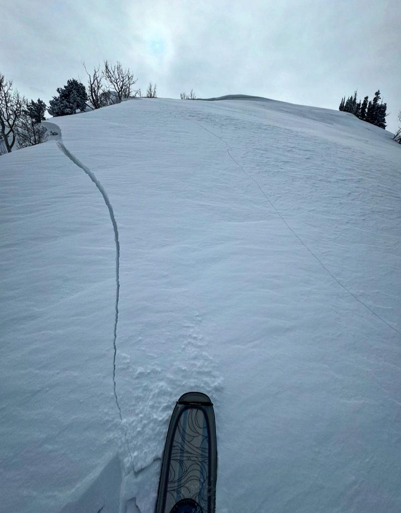
Yesterday, we had reports of shallow wind drifts along ridgelines in Little Cottonwood and Mill Creek Canyons. These shallow wind drifts will be easy to spot as they will be pillowy, rounded, and located on the windward side of ridgelines and terrain features. Shooting cracks are signs of wind drifting and you may see more of this today. Cornices point to where the snow is loading on the slopes and caution is advised before jumping onto or traveling underneath any wind loaded slope.
Photo (White) of a wind loaded slope with signs of cracking in Mill Creek.
Avalanche Problem #2
Persistent Weak Layer
Type
Location
Likelihood
Size
Description
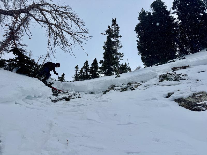
The buried facets that are near the ground have been with us since early December with most avalanche activity on this layer starting around Christmas. The last avalanche that failed on these facets was a skier triggered avalanche in Upper Big Cottonwood on Thursday January 16th. This layer of weak facets is no longer giving us obvious signs that it is going to avalanche. The cracking, collapsing, and whumpfing has subsided and the lack of in-your-face weakness makes for a tricky problem. Most likely areas to trigger an avalanche 2'-4' deep and up to 100' wide are thin rocky areas, gully features, and locations that have avalanched earlier this season. There is a great observation from Menk from Upper Days where he talks about repeater avalanches.
Photo showing the crown face and the facets that still make up the bed surface from an avalanche in Upper Big Cottonwood Canyon. Northwest aspect at 10,150'.
General Announcements
This information does not apply to developed ski areas or highways where avalanche control is normally done. This forecast is from the U.S.D.A. Forest Service, which is solely responsible for its content. This forecast describes general avalanche conditions and local variations always occur.