Join us at our 2nd Annual Blizzard Ball

Forecast for the Salt Lake Area Mountains

Trent Meisenheimer
Issued by Trent Meisenheimer on
Sunday morning, January 19, 2020
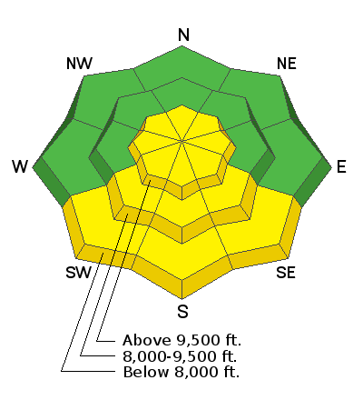
The avalanche danger is MODERATE on all upper elevation steep slopes for wind drifted snow avalanches. Seek slopes that were sheltered from Thursday and Friday's strong westerly winds.
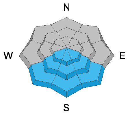
There is a MODERATE avalanche danger for wet snow avalanches on steep sunny slopes that face southeast, south, and southwest.
All other terrain has a LOW avalanche danger. Use safe travel protocols and carry a beacon, shovel and probe. Keep an eye on your partner.
If you're heading to Uinta mountains the avalanche danger is CONSIDERABLE. If you're heading to the Logan zone the avalanche danger is CONSIDERABLE. Both areas have a very different snowpack and I would encourage you to read the forecast specific to those areas.
Low
Moderate
Considerable
High
Extreme
Learn how to read the forecast here
Special Announcements
We are very sad to report an avalanche fatality that happened yesterday above Farmington Canyon. A 18 year old, male snowmobiler was caught, fully buried and killed. Preliminary info available HERE. We will re-visit the scene today and have a full report available in the coming days. Our deepest condolences go out to the friends, family, rescuers, and everyone affected by this tragic accident.
Weather and Snow
Today will be a beautiful day to be in the mountains with plenty of sunshine and light winds. Current mountain temperatures are in the teens °F at the upper elevations while the lower elevations sit just above the single digits °F. The winds have finally relaxed and are currently blowing northwest 5-10 mph across the high elevation terrain. Temperatures will climb into the low 30's °F at 8,800' and upper 20's °F at 10,000' by this afternoon. Ridgeline winds will remain 5-10 mph from the north and west.
Yesterday's sunny skies kissed the southerly terrain where this morning you will find a thin zipper crust. Aspects that did not see direct sun will have perfect settled powder. Enjoy!
Recent Avalanches
Many observations came in yesterday and you can find them all HERE. One notable avalanche was a cornice triggered remotely (from a distance) along the Cottonwood Ridge. In Bountiful Canyon a rider found a wind slab that was 20" deep and 40' wide, nobody was caught or carried. Other backcountry riders reported small wind drifted snow avalanches that were mainly 5"-10" deep and up to 50' wide. In the late afternoon there were reports of small wet snow avalanches on the steep sunny aspects.
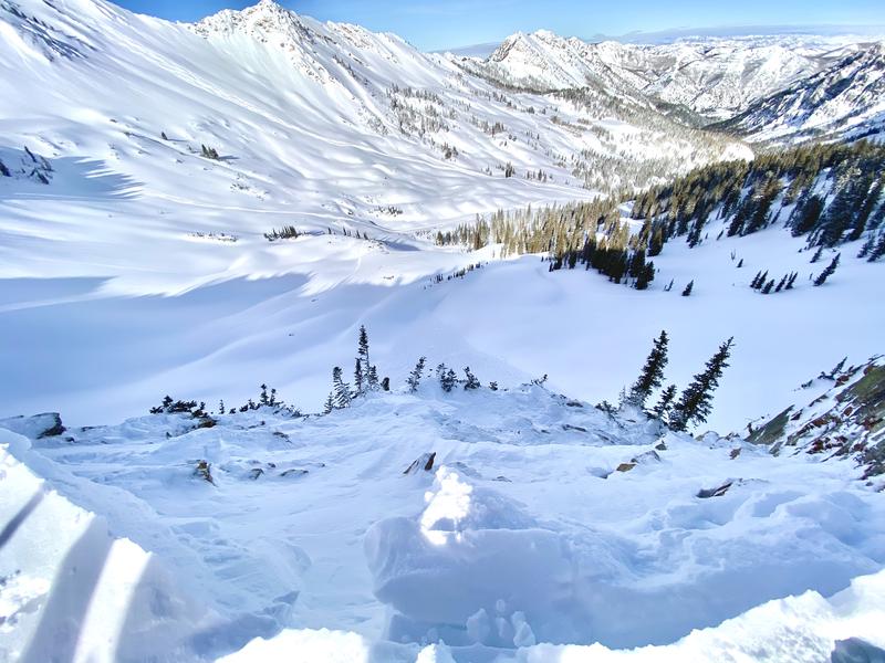
Photo: Showing a large remotely triggered cornice on the Cottonwood Ridge. (Grant K)
Ad
Avalanche Problem #1
Wind Drifted Snow
Type
Location
Likelihood
Size
Description
WIND DRIFTED SNOW: Lingering wind slabs will be the main concern today. Choose slopes with soft settled powder that have not been effected by the recent strong wind. Use terrain to your advantage by avoiding the steepest wind loaded starting zones. Remember, wind drifted snow often looks rounded and pillowy. Keep an eye out for mid slope break-overs and other terrain features that channeled the winds from the past couple of days. Cracking is a sign of instability.
CORNICE: Several days of strong winds have created large and sensitive cornices along the exposed ridgelines. Some of these cornices have dropped naturally, and many observers have noted they are quite sensitive as you approach them. Large cornices often collapse and break much further back than expected, so be sure to give them a wide berth when traveling along the exposed ridgelines.
Avalanche Problem #2
Wet Snow
Type
Location
Likelihood
Size
Description
As the January sun heats the southerly facing terrain today I would expect to see small wet snow avalanches. Wet snow will start with rollerballs underneath rock bands and with enough sun/heat we may even see some loose wet snow naturals as the day wears on. Keep an eye on the southerly slopes above you, if you start seeing signs of warm and wet snow it's time to move to a colder aspect.
General Announcements
This information does not apply to developed ski areas or highways where avalanche control is normally done. This forecast is from the U.S.D.A. Forest Service, which is solely responsible for its content. This forecast describes general avalanche conditions and local variations always occur.