Join us at our 2nd Annual Blizzard Ball

Forecast for the Salt Lake Area Mountains

Trent Meisenheimer
Issued by Trent Meisenheimer on
Saturday morning, January 18, 2020
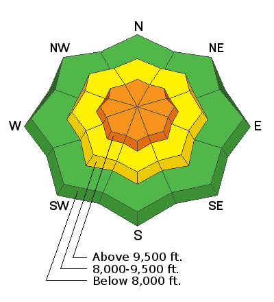
The avalanche danger is CONSIDERABLE on all upper elevation steep slopes for Wind Drifted Snow avalanches. At the upper elevations, some avalanches may step down into older weaker layers that have been dormant for some time. Lose the wind and lose the problem. Seek slopes that are sheltered from the wind.
Mid elevation steep wind loaded terrain has a MODERATE avalanche danger for Wind Drifted Snow avalanches.
At the lower elevations, the hazard is LOW where there is less wind-loading and storm snow.
HEADS UP: If you're heading to Uinta mountains the avalanche danger is HIGH. If you're heading to the Logan zone the avalanche danger is CONSIDERABLE. Both areas have a very different snowpack and I would encourage you to read the forecast specific to those areas.
Low
Moderate
Considerable
High
Extreme
Learn how to read the forecast here
Special Announcements
Get discount lift tickets HERE. Thanks for this generous support from Utah Ski Resorts and Ski Utah. All proceeds go directly to supporting the UAC.
Weather and Snow
Under mostly cloudy skies the upper elevation mountain temperatures are in the single digits °F. Lower elevations are hovering in the low teens °F. The saga of westerly winds continue as upper elevation anemometers currently spin at 10-15 mph gusting 20-25 mph. As you get off the ridgelines the winds are generally 5-10 mph. Yesterday's overachieving storm delivered blower powder and reset the landscape with a beautiful coat of white paint. Snow totals are as follows:
  • Upper Cottonwoods: 12"-18" (0.87 - 1.14" SWE)
  • Park City Ridgeline: 8"-12" (0.60" - 0.87" SWE)
  • Mid Big Cottonwood: 8"-13" (0.60" - 1.0" SWE)
  • Millcreek Canyon: 8"-10"
  • Provo Area: 4"-8"

For today, we can expect high clouds streaming overhead on a westerly flow with the chance of some sun this afternoon. Temperature will remain cold today before the ridge of high pressure amplifies tomorrow. The wind is forecasted to finally calm down by later today.
Mid elevation wind sheltered terrain offers the best riding and turning conditions with all time blower powder on all aspects. Westerly winds had their way with the upper elevation terrain and you will find wind damage in the open terrain and just off the ridgelines where the snow became slabby, firm and ultimately ruined the powder party.
Recent Avalanches
Yesterday's storm came in with a bang! winds increased rapidly and the snow fell at rates of 2-3" per hour. During this time we saw a natural avalanche cycle that was mainly confined to the new snow. However, the winner was the Y couloir as it produced a large natural slide that was caught on film by the Utah Department of Transportation (video below). HERE is the list to all observations from the backcountry.
Ad
Avalanche Problem #1
Wind Drifted Snow
Type
Location
Likelihood
Size
Description
Craig Gordon said it best "the most in-your-face avalanche problem today will be fresh drifts of wind blown snow." These drifts were created from the strong westerly wind transporting and loading our most recent storm snow onto a variety of aspects at the mid and upper elevation terrain. Upper elevation slopes facing north through southeast that received the most snow will be most suspect. Yesterday, in Millcreek Canyon I found the problem was confined to the ridgelines and as you descended just a hundred feet you lost the wind and therefore lost the problem.
For today - choose slopes with soft settled powder that have not been effected by the wind. Use terrain to your advantage by avoiding the steep wind loaded starting zones. Remember, wind drifted snow often looks rounded and pillowy. Wind can swirl in the mountains so keep an eye out for mid slope break-overs and terrain features that channel the wind. Cracking is a sign of instability.
Additionally, several days of strong winds have created large and sensitive cornices along most exposed ridgelines. Some of these cornices have dropped naturally, and many observers have noted they are quite sensitive as you approach them. Large cornices often can collapse much further back than expected, so be sure to give them a wide berth when traveling along exposed ridgelines.
Avalanche Problem #2
Persistent Weak Layer
Type
Location
Likelihood
Size
Description
There remains a layer of weak faceted snow that exist on all aspects at the upper elevations, making it possible to trigger an avalanche up to 2-4' deep. Although, this problem is moving towards dormancy, strong winds the past few days have overloaded several slopes where this weak structure exists, such as Tuesday's avalanche on South Monitor and Thursday in upper Little Cottonwood. On northerly aspects, the terrain that is most likely to avalanche will be on very steep, wind loaded, rocky terrain, or on repeater slopes where the snowpack is thinner.
General Announcements
This information does not apply to developed ski areas or highways where avalanche control is normally done. This forecast is from the U.S.D.A. Forest Service, which is solely responsible for its content. This forecast describes general avalanche conditions and local variations always occur.