Forecast for the Provo Area Mountains

Drew Hardesty
Issued by Drew Hardesty for
Sunday, March 6, 2022
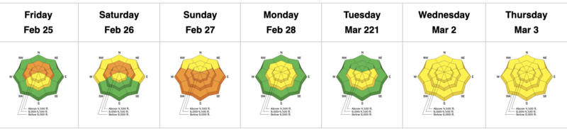
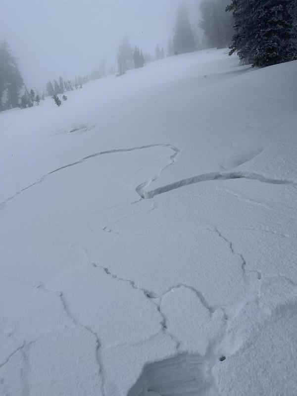
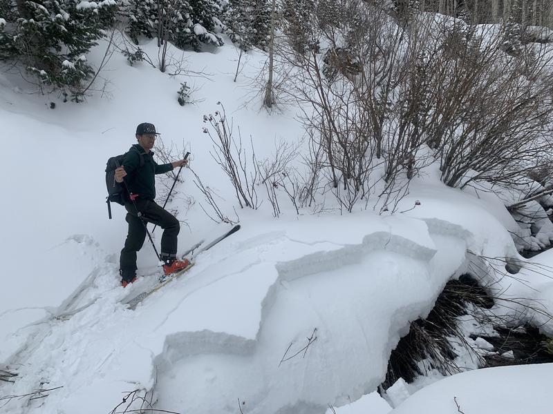
Areas of CONSIDERABLE avalanche danger exist on steep west to north to east facing aspects at the mid and upper elevations. You can trigger 1-2' deep avalanches failing on a buried persistent weak layer and you may be able to trigger them from a distance. Cracking and collapsing may or may not be present. A tricky MODERATE danger exists for this problem on low elevation shady aspects.
A MODERATE danger exists for new snow avalanches on all aspects and elevations this morning.
*Careful snowpack evaluation, cautious route-finding, and conservative decision making is essential today.
Low
Moderate
Considerable
High
Extreme
Learn how to read the forecast here
Special Announcements
Join us on Wednesday, March 9th at the Broadway Theater in SLC for a special screening of the award-winning film “BURIED,” a feature-length documentary based on the events and circumstances surrounding the 1982 avalanche in Alpine Meadows, CA. The show starts at 7 pm. Purchase tickets HERE.
Weather and Snow
Winter has returned! ...And lightning is rippling through the valley as I write...
It looks like the Provo mountains picked up another 2-3" overnight with storm totals of about a foot of new snow and 1.10" of snow water equivalent. This will dramatically improve riding conditions and coverage.
Mountain temperatures are in the upper teens up high, the low 20s down low.
Winds blew 15-20mph with gusts from the southwest overnight, but have since calmed to 10mph with gusts to 15.
Winds will veer to the northwest during the day and snowfall will become more showery.

Another weak system ripples by tomorrow with a more potent storm early/mid week.
Recent Avalanches
The Provo avalanche conditions are complex. Yesterday, warming and greenhousing led to some wet avalanching in steep north facing gullies in Provo canyon. Further north based out of American Fork, a party experienced red flag cracking and collapsing at 9000' on the north side of Timpanogos (OBSERVATION)...and Dave Coyne and his partner not only found red flag snowpack tests and were able to trigger some soft slabs on damp facets at low elevations on the east side of Box Elder. (OBSERVATION).
Be sure to check out all the observations HERE.
Greg Gagne's Week in Review is published and can be found HERE.
Ad
Avalanche Problem #1
Persistent Weak Layer
Type
Location
Likelihood
Size
Description
THESE TWO PHOTOS FROM YESTERDAY ARE RED FLAGS
A foot or more of snowfall is additional stress on our Jan/Feb drought layer PWL of buried facets, now buried 8-20" deep primarily on west to north to east facing aspects now at all elevations. Cracking and collapsing may or may not be evident but I don't trust this poor snow structure. I think it will be dangerous and active in localized terrain. UAC staff member Dave Coyne explains what he found yesterday.
My worry is that the new snow insulating these damp facets will keep them from freezing and locking up. Low elevation northerly slopes should remain on your radar for today.
Trend: steady
Avalanche Problem #2
Wind Drifted Snow
Type
Location
Likelihood
Size
Description
Due to the positioning of the storm system, areas of Provo experienced the most wind and soft wind slabs will be found on many west to north to east facing aspects. Note than terrain channelling can have them on many apects but they will be most pronounced on west to north to east facing slopes. Shooting cracks are indicators of slab formation; avoid rounded and pillowy snow features.
Avalanche Problem #3
New Snow
Type
Location
Likelihood
Size
Description
New snow instabilities will be most pronounced during any period of high snowfall rates. I would use test slopes and hand pits to see how the snow is reacting under my feet.
Trend: increasing stability
Additional Information
Forecaster's Corner
I am most suspicious of northwest to east aspects at the mid elevations but include all elevations facing west to north to east.
I think the skiing and riding will be great, but my recommendation would be to avoid all steep northwest to easterly facing aspects of all elevations until we reduce our overall uncertainty with this layering and the snowpack has had some time to adjust. (Admittedly with additional storms on the horizon, this may be awhile.). The best and safest riding conditions will be on low angle solar (southwest to southeast ) or low angle polar (northwest to northeast).
Powder frenzy often trips up our better judgement. Avalanche conditions will be dangerous in some areas today. When I have a fair bit of uncertainty, I tend to provide for wide margins of safety.
General Announcements
Who's up for some free avalanche training? Get a refresher, become better prepared for an upcoming avalanche class, or just boost your skills. Go to https://learn.kbyg.org/ and scroll down to Step 2 for a series of interactive online avalanche courses produced by the UAC.
This information does not apply to developed ski areas or highways where avalanche control is normally done. This forecast is from the U.S.D.A. Forest Service, which is solely responsible for its content. This forecast describes general avalanche conditions and local variations always occur.