Forecast for the Provo Area Mountains

Evelyn Lees
Issued by Evelyn Lees for
Saturday, March 23, 2019
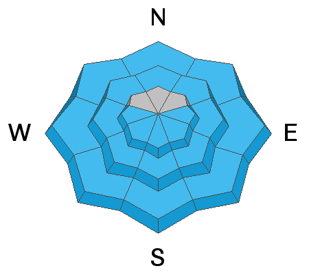
The avalanche danger is MODERATE on steep upper elevation slopes facing northwest through north through northeast, where slabs of wind drifted snow failing on the old dry snow can be triggered. Other terrain has a LOW avalanche danger early this morning, but the danger will increase to MODERATE for wet snow sluffs with heating and sun.
Low
Moderate
Considerable
High
Extreme
Learn how to read the forecast here
Special Announcements
Catch up with Greg’s Week in Review HERE.
The latest blog-casts are out - Shame and the Social Contract and Stacking the Deck.
Weather and Snow
A mix of light snow and rain has been falling in the Provo area mountains, with 3 day totals still only a few inches at the mid elevations.
This morning, there could be a few more light rain and snow showers, with minimal accumulations. Skies will then start to clear, leaving a mix of sun and high thin clouds for the afternoon. Temperatures are currently in the upper 20s to mid 30s at the low to mid elevations, and will soar into the mid 40s at 8,000’ and low 30s at 10,000’. The southwesterly winds are averaging 10 mph, gusting to 15 mph, should remain that way, though the high peaks could average 15 to 25 mph, gusting to 35 mph at times.

Recent Avalanches
No new observations from the Provo area mountains.
Ad
Avalanche Problem #1
Wind Drifted Snow
Type
Location
Likelihood
Size
Description
Upper elevation terrain is the most likely place to find and trigger wind drifts that formed over the past few days. The weak layer would the loose, dry snow that was on the upper elevation, shady slopes before Thursday’s snow. The slab is a combination of various wind slabs and the new snow.
Approach steep, upper elevation shady slopes with caution - this is where slab avalanches can be triggered today, possibly remotely or breaking out above you when you’re part way down a slope. Small soft slabs and loose sluffs can be triggered in higher elevation terrain. Even a small slide can have serious consequences in big, steep terrain or if you’re above cliffs.
A short video by Greg Gagne explaining layering on an upper elevation northeasterly facing slope in White Pine where there was collapsing on Thursday.
Avalanche Problem #2
Wet Snow
Type
Location
Likelihood
Size
Description
Wet snow sluffs are likely today when the sun comes out - both natural and easily human triggered. The high sun angle combined with periods of thin clouds means the snow will heat on all aspects. The more new snow and steeper the terrain where you are, the bigger these sluffs have to the potential to be. Running on the old melt freeze ice crusts, they may go much further than expected. When the snow gets damp, head to lower angle slopes and avoid travel in and below run out zones, like gullies.
Roof slides can occur at any time, especially with warming temperatures - always avoid travel beneath snow laden roofs and warn others.
Glide cracks can release at any time, sending the whole season’s snowpack down slope. Avoid spending time below the yawning cracks.
Cornices become more sensitive with heating, and are too large to tangle with or try to intentionally trigger. Avoid these monsters.
Additional Information
Slide-for-life’s may be possible on the hard crusts beneath the new snow. Consider some combination of crampons, ski crampons, Whippets or an ice axe if you’re heading into very steep, alpine terrain. Carry skin wax and a scraper to deal with alternating dry and damp snow.
General Announcements
This information does not apply to developed ski areas or highways where avalanche control is normally done. This forecast is from the U.S.D.A. Forest Service, which is solely responsible for its content. This forecast describes general avalanche conditions and local variations always occur.