Forecast for the Provo Area Mountains

Evelyn Lees
Issued by Evelyn Lees for
Friday, March 22, 2019
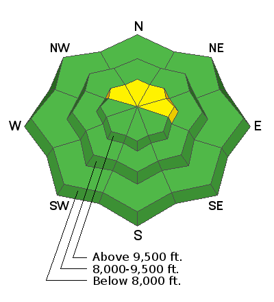
The avalanche danger is MODERATE on steep upper elevation slopes facing northwest through north through northeast, where slab avalanches failing on the old dry snow can be triggered. Other terrain has a LOW avalanche danger, though small sluffs and soft slabs can be triggered, especially this afternoon during periods of snowfall or increased wind. Avoid spending time beneath cornices, glide cracks and steep roofs.
Low
Moderate
Considerable
High
Extreme
Learn how to read the forecast here
Special Announcements
While mostly for the SLC area mountains, still has valuable info. Catch up with Greg’s Week in Review HERE.
The latest blog-casts are out - Shame and the Social Contract and Stacking the Deck.
Weather and Snow
Winter is trying to make a comeback, but needs a bit more encouragement. The first 2 shots of snow (yesterday and overnight) have left a total of about 1 to 3” at the low to mid elevations of the Provo area mountains. Most terrain is dust on crust, the exception upper elevation, northwest through northeasterly facing slopes, where there is soft snow beneath the new. Dodging hidden frozen ice chunks, avalanche debris and “curb and gutter” frozen tracks will take skill.
This morning, under cloudy skies, temperatures are in the mid to upper twenties at the mid elevations, and near freezing at the low elevations. An additional 1 to 3 inches of snow is expected today, mostly after noon, with convective showers and lightning possible. Highs today will be in the upper 30s at 8,000’ and the upper 20s at 10,000’. Winds will be from the south to southwest, averaging 20 to 25 mph at times, with gusts to 40. Currently, they've been averaging 10 to 15 mph, with gusts to 20 at 8,200'.
Recent Avalanches
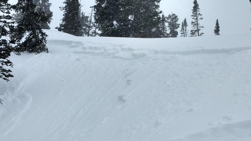
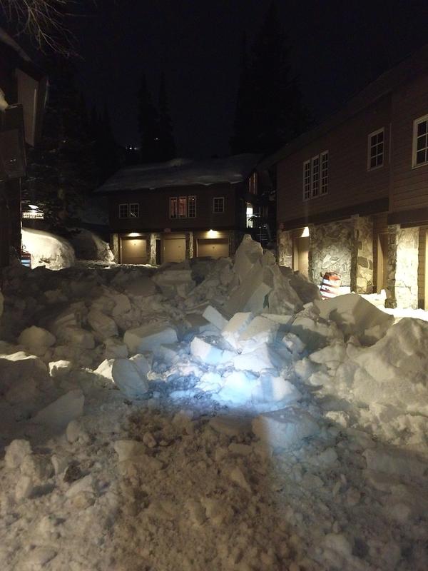
No new observations from the Provo area mountains. These observations from the Salt lake area mountains are probably representative of what's happening in parts of the Provo area mountains. Yesterday, there were a couple of intentionally triggered new snow soft slabs on northerly facing facing slopes in Flannigans (Silver Fork) and Dog Lake chutes, about 6” deep and 20 to 80' wide. Collapses were noted on the ridgeline near the top of Main Days and in upper White Pine, both on northeasterly facing slopes above 10,000’, failing on the old dry snow beneath Wednesday’s hard wind slab. Another huge roof-a-lanche occured around 3 am this morning in upper Little Cottonwood. Small, but long running soft slabs on hard snow surfaces were easy to trigger yesterday morning, settling out by afternoon.
Shallow, new snow soft slab, Dog Lake Chute. Photo by Chester.
3 am roof avalanche, LCC. Photo Dave Richards.
Ad
Avalanche Problem #1
Wind Drifted Snow
Type
Location
Likelihood
Size
Description
Yesterday’s collapsing in two different drainages is a red flag. The weak layer is the loose, dry snow that was on the upper elevation, shady slopes above about 9,500’. The slab is a combination of Wednesday’s wind slabs and/or yesterday’s new snow and wind slabs. Approach steep, upper elevation shady slopes with caution - this is where wider slab avalanches can be triggered today, possibly remotely or breaking out above you when you’re part way down a slope.
A short video by Greg Gagne explaining layering on an upper elevation northeasterly facing slope where there was collapsing.
Avalanche Problem #2
Normal Caution
Type
Location
Likelihood
Size
Description
While most terrain has a LOW danger, a deep snowpack, new snow, wind and the transition from winter to spring means staying alert.
Shallow soft slabs and loose sluffs can be triggered on all aspects, especially in wind drifted terrain or during heavier snowfall this afternoon. Even a small slide can have serious consequences in big, steep terrain or if you’re above cliffs.
Deeper faceted weak layers exist in some terrain of the Provo area mountains, and digging down 4 or 5 feet is a good idea when looking for weak layers in the snow pack.
If the sun comes out for even a moment, damp sluffs an be triggered on steep slopes.
Cornices are too large to tangle with or try to intentionally trigger. Avoid these monsters.
More roof slides released this morning - always avoid travel beneath snow laden roofs and warn others.
Glide cracks can release at any time, sending the whole season’s snowpack down slope. Avoid spending time below the yawning cracks.
Additional Information
Slide-for-life’s may be possible on the hard crusts beneath the new snow. Consider some combination of crampons, ski crampons, Whippets or an ice axe if you’re heading into very steep, alpine terrain. Carry skin wax and a scraper to deal with alternating dry and damp snow.
General Announcements
This information does not apply to developed ski areas or highways where avalanche control is normally done. This forecast is from the U.S.D.A. Forest Service, which is solely responsible for its content. This forecast describes general avalanche conditions and local variations always occur.