Forecast for the Provo Area Mountains

Trent Meisenheimer
Issued by Trent Meisenheimer for
Saturday, March 2, 2024
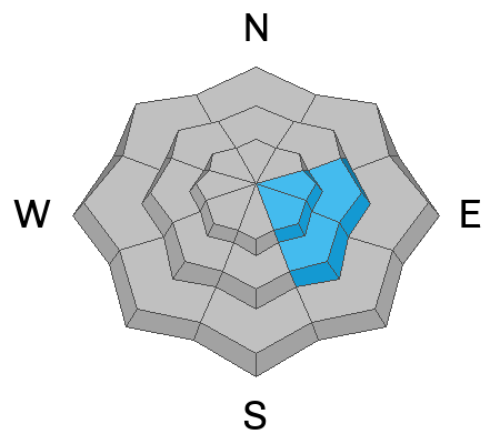
The avalanche danger is CONSIDERABLE at the mid and upper elevations on slopes with new and recent slabs of wind-drifted snow. Fresh wind drifts may be found on all aspects, including well down into drainage bottoms which are usually wind-protected.

As the storm arrives this afternoon, heavy snowfall and strong winds will likely increase the avalanche danger to HIGH.
Low
Moderate
Considerable
High
Extreme
Learn how to read the forecast here
Special Announcements
We are seeking a passionate individual to join us as Executive Director of the nonprofit Utah Avalanche Center.

Did you know we record a ~530AM Dawn Patrol hotline? (888-999-4019 option 6)
Weather and Snow
A large and powerful cold front is ushering in some of the strongest southwest winds we've seen this season. Current wind speeds average 30-40 mph gusting into the 60s and 70s across many upper-elevation ridges. It's windy! Mountain temperatures range from 20-30 °F.
Today the southwest wind will continue to blow at speeds of 30-50 mph, gusting into the 60s, 70s, and 80s across the upper elevations. Snowfall will begin this morning but accumulations will only be a few inches of new snow until the cold front arrives. The frontal passage looks to be later this afternoon, around 2:00 to 6:00 PM. At this time, the winds will peak and veer to the west-northwest, where we will see a burst of snowfall with rates hitting 2-4 inches per hour. Snow will continue overnight and into Sunday. Totals could be 15-25 inches (1.25-2.00" swe) by Monday.
Recent Avalanches
Yesterday, no new avalanche activity was reported. You can find all the observations HERE.
Ad
Avalanche Problem #1
Wind Drifted Snow
Type
Location
Likelihood
Size
Description
Strong southwest winds have been relentless for the past 24 to 48 hours. These strong winds have and will continue to change the landscape. Some slopes will become scoured, while others will have slabs of wind-drifted snow deposited. These drifts of wind-blown snow could be soft or hard today. I am unsure of how deep or wide they could break.
With such strong winds, you'll want to constantly be on the lookout for wind-drifted snow across all aspects and elevations. This includes mid-slope-break-overs, cross-loaded gullies, drainage bottoms, and any other terrain feature on which the wind has drifted the snow. Wavey, stiff, hollow, sounding snow is likely a wind slab.
Any new snow that falls will quickly be whipped into fresh drifts of wind-blown snow and will likely be sensitive to the weight of a rider.
Avalanche Problem #2
New Snow
Type
Location
Likelihood
Size
Description
As the cold front arrives this afternoon (roughly 2:00-6:00 PM), you can expect the avalanche danger to instantly spike because of heavy snowfall and strong winds. Snowfall rates with the frontal passage are forecast to be 2-4 inches per hour. This is a very rapid load to the snowpack.
Dry-loose avalanches and avalanches failing within the new snow will happen almost immediately. I wouldn't be surprised to see the avalanche danger rise to HIGH for a few hours later this afternoon/evening as I suspect we will see a widespread avalanche cycle within the new snow at some point.
Avalanche Problem #3
Persistent Weak Layer
Type
Location
Likelihood
Size
Description
A weak facet/crust layer buried by the Valentine's Day storm led to a number of slab avalanches on solar aspects (primarily east and southeast facing aspects) at the mid and upper elevations. This layering has become increasingly stable, but avalanches remain possible.
General Announcements
This information does not apply to developed ski areas or highways where avalanche control is normally done. This forecast is from the U.S.D.A. Forest Service, which is solely responsible for its content. This forecast describes general avalanche conditions and local variations always occur.