Forecast for the Provo Area Mountains

Trent Meisenheimer
Issued by Trent Meisenheimer for
Sunday, March 10, 2024
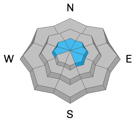
The Avalanche danger is MODERATE on steep upper-elevation slopes for soft or hard slabs of wind-drifted snow.
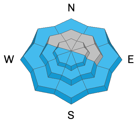
As the sun warms the snow surface the avalanche danger could rise to MODERATE for shallow wet-loose avalanches.
You will find a LOW avalanche danger in terrain protected by the sun and wind. This is also where the best riding will be.
Low
Moderate
Considerable
High
Extreme
Learn how to read the forecast here
Special Announcements
As we transition to a generally stable snowpack and many are starting to pursue bigger objectives, be sure to read Drew Hardesty's latest blog, "Is it REALLY Low Danger?"
Weather and Snow
Unfortunately, the southwest wind picked up yesterday around 7:00 PM and continues to blow this morning at speeds of 15-25 mph with gusts into the 30s and 40s across the upper elevations. Mountain temperatures are about 10 degrees warmer than yesterday and range from 25-35 °F.
Today, we expect the southwest wind to stay elevated ahead of a quick-moving trough (storm) that will impact us on Monday. Clouds will also be increasing throughout the day. Temperatures will climb into the mid to low 40s °F at 8,500'.
The sun and wind have damaged a lot of snow surfaces. However, you can still find soft settled powder on wind and sun-sheltered slopes. Take advantage of the beautiful day and generally more stable conditions as this week looks stormy.
Recent Avalanches
Yesterday the Wasatch Powderbirds noted a large natural avalanche on the east-southeast side of Cascade Mountain. They said it looked to be about 3-4 feet deep. Not many details on this.
Ad
Avalanche Problem #1
Wind Drifted Snow
Type
Location
Likelihood
Size
Description
It's truly a bummer that the southwest wind has picked up. With current wind speeds blowing 15-25 mph across the mid and upper elevations, one would have to expect a fresh round of soft or hard slabs of wind-blown snow (wind slabs) that formed overnight into this morning.
If you're heading for a peak or a big line, you'll want to change your mindset today and be on the lookout for snow that looks round, wavy, and pillowy or snow that sounds hollow like a drum. Wind slabs could be reactive today with this increase in wind.
Avalanche Problem #2
Wet Snow
Type
Location
Likelihood
Size
Description
I have no clue how the snow will react today with sunshine and warming temperatures. What I do know is it's March, and temperatures are forecast to hit the mid 40s°F at 8,500' today. A lot will depend on the cloud cover and wind speeds. It could stay cool enough in one place and be super hot in another. We might see zero activity, or it could be very active. You will have to be the forecaster today on this one.
Pay attention to how the snow surface is warming on all aspects and elevations. High-thin clouds make me think green housing is possible today. This means even the northerly-facing terrain could get warm and damp. If you notice roller balls or you start to sink into the snow, it's time to head for a cooler aspect.
General Announcements
This information does not apply to developed ski areas or highways where avalanche control is normally done. This forecast is from the U.S.D.A. Forest Service, which is solely responsible for its content. This forecast describes general avalanche conditions and local variations always occur.