Skies are mostly cloudy.
Winds are from the southwest, with mid and upper elevation anemometers registering wind speeds of 25mph with gusts to 35.* Mountain temperatures are in the mid to upper 20s. A weak going-through-the-motions "storm" will cast off a snowflake or two today. Winds should lose steam by the afternoon hours; temps will be in the 20s.
All eyes are on what I'm calling a Good News and Bad News Tuesday/Wednesday/Thursday storm. The GOOD news: A slow moving Pacific storm will bring cooler temps and perhaps 12-18" of snow to the mountains. The BAD news: strong east to northeast winds follow for Wednesday night to Thursday night and we finally wriggle free of the grasp of this nuisance of a weather system by Friday. With this much wind (particularly from the east), it's probably not even worth the trouble.
(*In last Tuesday's forecast, I said One more day of wind, people. I did not mean for the rest of the season.).
Backcountry conditions: Travel is easy but snow conditions are a bit tired and worn. It's still possible to find some soft snow that's not sun or wind damaged, but you'll have to be sneaky. Be aware that lower elevation snow may be punchy and unsupportable after a poor overnight refreeze.
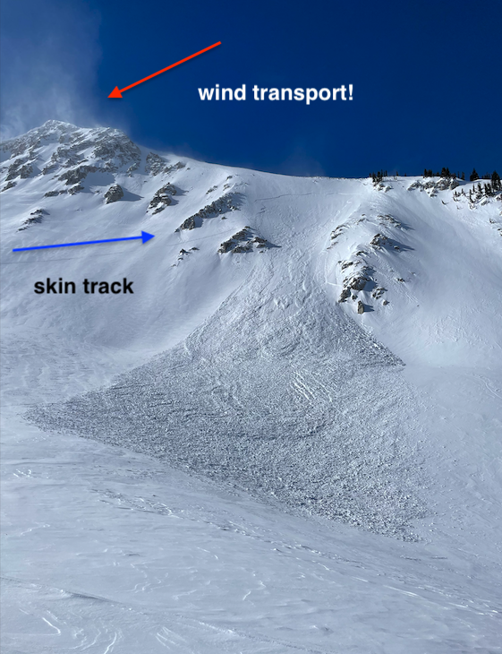
No avalanches were reported in the Provo area mountains, but I can report no fewer than four skier triggered slides in the central Wasatch backcountry yesterday. The relentless winds have deposited pockets of hard and soft slab across a variety of aspects, even well off the ridgelines and two skiers were caught and carried in separate incidents while ascending. Some of these have very nice write-ups. The list below:
Airplane Peak - NE facing at 10,300' 6" deep and 200" wide (photo)
Bells Canyon - East facing at 9600' reported 1-2' deep 100' wide
White Pine - Northwest facing at 9800', estimated 8-18" deep and 50' wide