UDOT PLANNED AVALANCHE CLOSURES!!

Forecast for the Provo Area Mountains

Evelyn Lees
Issued by Evelyn Lees for
Friday, March 1, 2019
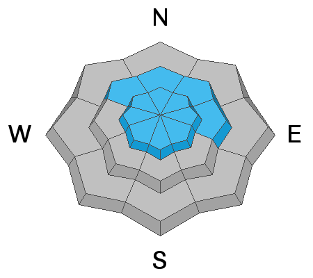
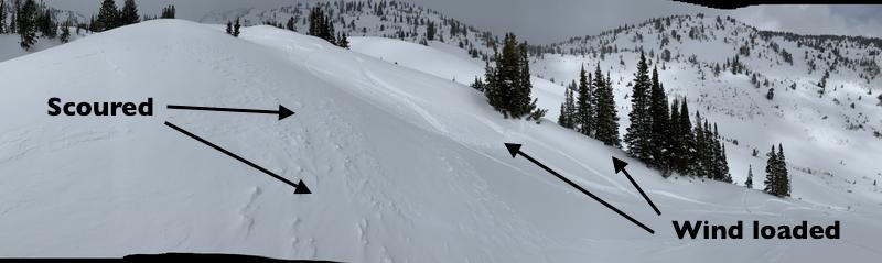
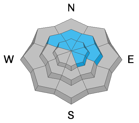
A MODERATE AVALANCHE DANGER exists on steep, wind drifted slopes at the upper elevations and some mid elevation slopes. These reactive wind drifts will be most widespread on northwest through easterly facing slopes, and their size will increase with elevation. These avalanches are large enough to catch, carry and even bury a person, and could run far and fast on the hard old surfaces. There is also a MODERATE danger of triggering a larger avalanche breaking on a persistent weak layer near the ground, most likely on a slope with a shallow snow pack. Other terrain has a LOW avalanche danger, though isolated, small wind drifts or wet loose sluffs can still be triggered.
Low
Moderate
Considerable
High
Extreme
Learn how to read the forecast here
Special Announcements
The latest podcast with Ian McCammon has been published. Check it out HERE.
Like clockwork, the Week in Review has arrived. While the focus is on the Salt Lake area mountains, there is valuable general information on the past week’s weather and avalanches.
Weather and Snow
About 1 to 3” of dense snow has fallen in the past 24 hours in the Provo area mountains, the best kind to start to fill in and cover the variable surfaces of wind board, sastrugi and crusts. The lower angle slopes will be the most filled in and ride the best. A few more snow showers possible this morning, with mostly cloudy and foggy skies today. Snow may start to fall again this afternoon, with another few inches possible by tomorrow morning.
Temperatures have cooled, and are now in the 20s, and the rain/snow line has dropped. The small front is past and stalled out around Nephi, and the winds have shifted back to the southwestand decreased - 15 mph averages with gusts in the 30s at the mid elevations. Overnight, averages were in the 15 to 20 mph range, with. But there is a significant bump in speeds above about 10,500’ to the north where there are upper elevation wind sites - averages of 30 to 40 mph, with gusts in the 50s.
Recent Avalanches
No new avalanches reported yesterday, though continued loading by the wind was observed in isolated places at mid and upper elevations, with new sensitive cornices developing in spots. In the Ogden area mountains yesterday, with a bit more snow and wind, sensitive drifts 8 to 12” deep had formed by the end of the day.
Ad
Avalanche Problem #1
Wind Drifted Snow
Type
Location
Likelihood
Size
Description
Sensitive new wind drifts have been created by the southwest winds from the few inches of storm snow. These soft wind drifted will be very reactive to a person or ski cuts on steep slopes, resulting in avalanches large enough to catch and carry a person. The drifts could be a foot or more deep at the higher elevations. On slopes with hard, slick sun crusted and wind hammered surfaces beneath the new snow, these slides could pick up steam and run further and faster than expected, with debris large enough to bury a person.
The drifts will become more widespread and deeper the higher you go in elevation, because there is more wind and snow. Avoid these slabs of wind drifted snow on steep slopes. Wind drifts are often rounded, smooth, and cracky. If you see a slope that’s been scoured or eroded, think about where the snow may have been deposited.
The large cornices have become a permanent part of the landscape, and today's winds are adding another layer to them. The old cornices will break back much further than expected, and the new cornices will be very sensitive today.
Mary Ellen gulch, Nason photo.
Avalanche Problem #2
Persistent Weak Layer
Type
Location
Likelihood
Size
Description
Assessing the snowpack in the Provo area mountains in avalanche terrain at mid and upper elevations on NW, N, NE, E aspects (and upper elevation SE) is difficult. Recent natural avalanches have broken at the ground in the Provo mountains, and control work on Sunday at a Cottonwood resort in the Salt Lake mountains produced a slide breaking down 3-4' deep in facets at the ground . Although it is hard to assess the likelihood of triggering one of these avalanches, the consequences of getting involved in one is likely deadly. The only mitigation strategy we have is to avoid avalanche terrain for now.
Additional Information
As temperatures continue to cool, so does the wet snow at the low and mid elevations. Still, it may be possible to get a wet loose sluff moving in unconsolidated snow on a very steep slope at the lower elevations, such as a gully, creek or road bank.
General Announcements
This information does not apply to developed ski areas or highways where avalanche control is normally done. This forecast is from the U.S.D.A. Forest Service, which is solely responsible for its content. This forecast describes general avalanche conditions and local variations always occur.