Forecast for the Provo Area Mountains

Drew Hardesty
Issued by Drew Hardesty for
Thursday, February 23, 2023
Areas of CONSIDERABLE avalanche danger exist across the compass. Human triggered avalanches are likely.
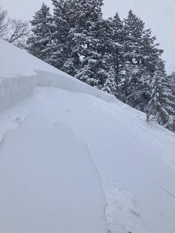
Know that you can also trigger soft slab avalanches in the low elevation bands today.
Careful snowpack evaluation, cautious route-finding and conservative decision making is essential.
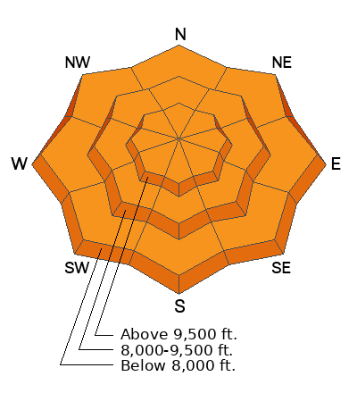
Low
Moderate
Considerable
High
Extreme
Learn how to read the forecast here
Weather and Snow
Skies are currently overcast but the mountains picked up an additional 6-10" overnight, pushing storm totals to roughly 36" and 3.26" of snow-water equivalent.
Temperatures are in the single digits and low teens. Winds are now out of the southwest, blowing 20-25mph with gusts to 30mph.

We have another system lined up to deliver another round of snow from the southwest this afternoon. We may see an additional 2-5" by early evening with storm totals of 4-9" by tomorrow morning. Mountain temperatures will be in the teens. Winds will blow 20mph from the southwest, increasing to 30mph by the afternoon.

We'll get a bit of a break later Friday into Saturday before the next storm lines up for Sunday. The longer range models have storms until the end of time.
Recent Avalanches
Ski area avalanche teams found very sensitive very active avalanche conditions yesterday with easy to trigger soft slabs within the new snow on a variety of aspects and elevations. A backcountry skier in the Bob's area above Aspen Grove found similar conditions.
I do want to report two avalanches from the Ogden area mountains that may have some bearing on the Provo mountains:
Two significant avalanches to report from the Ben Lomond area. Each of these were triggered in the low elevation band (below 7000').
Northeast facing at 6500' - this was triggered remotely. 2' deep and 150' wide.
East facing at 6900'. 2' deep; width unknown.
Check recent observations HERE>
Ad
Avalanche Problem #1
Wind Drifted Snow
Type
Location
Likelihood
Size
Description
Owing to yesterday afternoon's increasing northwest winds along the higher elevations and today's increasing southwest winds, you'll find soft slabs of wind drifted snow around the compass at the mid and upper elevations. These drifts will be 1-2' deep and sensitive to provocation. Watch for shooting cracks or audible whumphing in the new drifts....
Avalanche Problem #2
New Snow
Type
Location
Likelihood
Size
Description
Lingering new snow instabilities exist around the compass AT ALL ELEVATIONS. This is uncommon and I want you to keep the low elevation bands on your radar, even if you are just traveling through the low elevations.
Between the Ogden and SL mountains yesterday, three soft slab avalanches were triggered at a distance 1-2' deep and 100'-150' wide in these low elevation bands.
Know that you'll also be able to easily trigger loose long running sluffs in the new snow in the steeper terrain, particularly with the additional snowfall this afternoon.
****One thing of note: These avalanches in Ben Lomond area look like benign terrain through the scrub oak....but remember: slope angle is slope angle. It's all avalanche terrain if it's steep enough.
General Announcements
This information does not apply to developed ski areas or highways where avalanche control is normally done. This forecast is from the U.S.D.A. Forest Service, which is solely responsible for its content. This forecast describes general avalanche conditions and local variations always occur.