31st Annual Backcountry Benefit - September 12th - Tickets Available Here!

Forecast for the Provo Area Mountains

Dave Kelly
Issued by Dave Kelly on
Monday morning, February 12, 2024
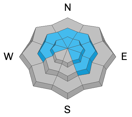
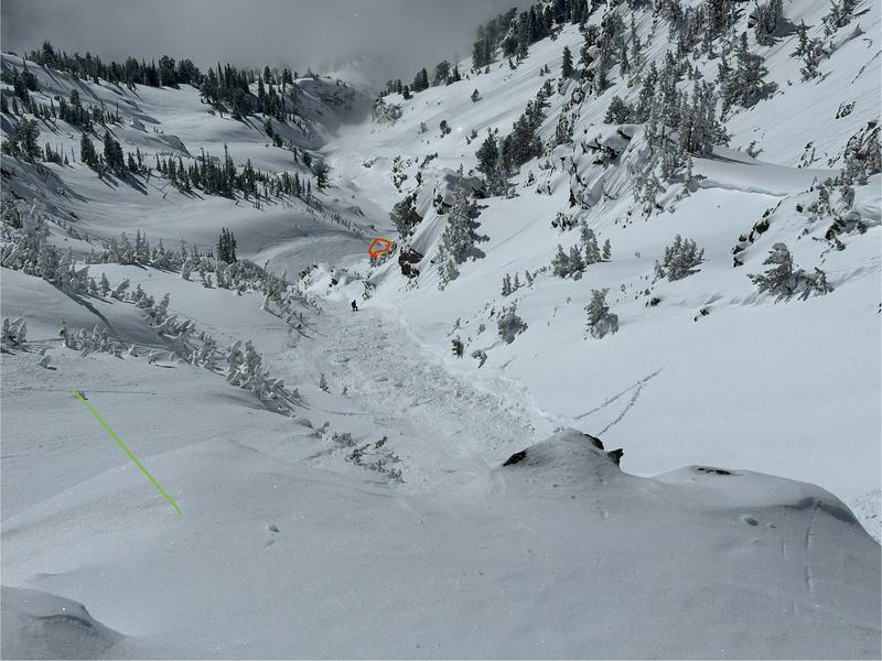
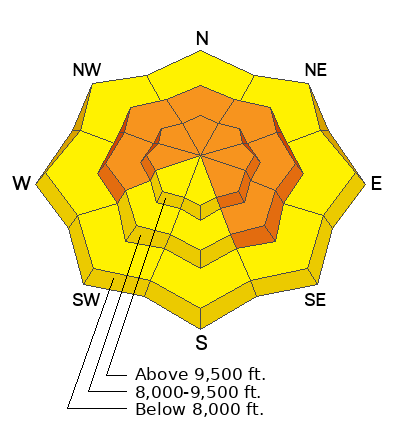
Today, the avalanche danger remains CONSIDERABLE at the upper and mid-elevation slopes facing west through north and southeast. Slab avalanches may fail in a persistent weak layer up to 4'- 6' deep. On all other slopes, the avalanche danger is MODERATE.
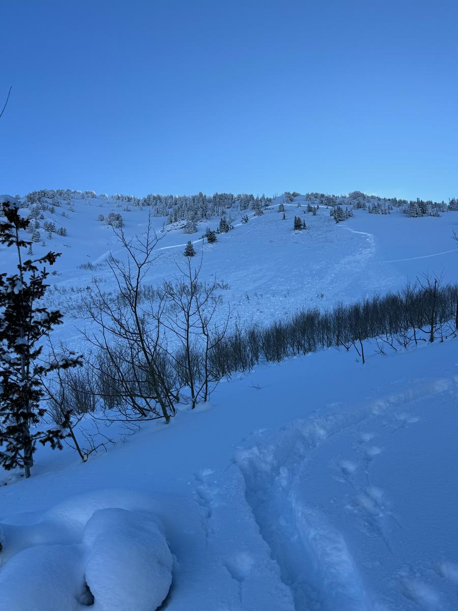
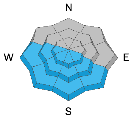
Avalanche terrain can be easily avoided today, as there is excellent riding on lower-angled shady slopes. Terrain Management is key to a safe day in the mountains.
Low
Moderate
Considerable
High
Extreme
Learn how to read the forecast here
Weather and Snow
This morning, under partly cloudy skies trailhead temperatures are in the single digits °F, the mid-elevation weather stations are in the high-teens °F. Winds are blowing from a westerly direction 10 gusting to 20 MPH. There was no new snow overnight and cold clear conditions led to faceting of the surface snow.
For today, look for clear skies with temperatures from 34-37°F. Winds will blow from a westerly direction 10 gusting to 15 MPH at the 9,000' ridgelines and 30 gusting to 45 MPH at the 11,000' ridgelines. Winds are forecast to increase throughout the day. No new snow is forecast for today.
Cold temperatures over the last week have led to blower travel conditions and there is still great riding on higher elevation and shady aspects less than 30 ° that haven't been sun-affected.
Recent Avalanches
This was an active avalanche weekend in the backcountry.
  • Skier triggered- Upper Pole Canyon- 10,000' West Aspect-New Snow avalanche 3' deep- 30' wide- caught 2 people
Some stand out avalanches from just north of the Provo area are listed below:
  • Skier triggered-Broads Fork Twins-Lisa Falls 11,200 Southeast Aspect- Wind-drifted snow avalanche 2' deep - ran 1500' vertical-Helicopter Evacuation
  • Unknown trigger-Main Gobblers - Millcreek Canyon - 9800' - Northwest Aspect - Hard slab failing on facets 5' deep - 400' wide - ran 2000' vertical
  • Skier triggered-Cardiac Ridge - Cardiff Fork - 10,800' - East Aspect - Hard slab failing on facets 3.5-4' deep - 350' wide-ran 1000' vertical
  • Snowboarder triggered-Pioneer Ridge- Toilet Bowl- 10,200'- North Aspect- Hard slab failing on facets 3' deep-70' wide-ran 200' vertical
    There were many avalanches reported over the weekend and many more reports of great travel and people getting out and about without any avalanche involvements. There are 2 great reports one from Sean Z HERE, and one from Drew et al HERE.
    Read all the observations HERE.
Photo of an avalanche with an unknown trigger near Bob's Knob (Pic:Woody)
Ad
Avalanche Problem #1
Persistent Weak Layer
Type
Location
Likelihood
Size
Description
This weekend's avalanches failing in the persistent weak layer (PWL) should serve as a reminder that this avalanche problem remains a concern, particularly in the most suspect areas—steep, shallow, and rocky terrain features, or areas that have previously avalanched are most suspect.
The bottom line is that there's more weight, resulting in larger avalanches.

Photo of a persistent weak layer (failed on dry facets) avalanche from Main Gobblers.
Avalanche Problem #2
Wet Snow
Type
Location
Likelihood
Size
Description
With today's continued warming temperatures and the bright Utah sun solar facing aspects (southeast-south-west) will start to shed snow. Watch for snow falling off rocks and stay out of steep gully features as the day warms up. Roof-lines that are still holding snow may start to shed today. Be aware of children playing or adults shoveling solo or working around the house as they are the most vulnerable to roof slides.
Avalanche Problem #3
Wind Drifted Snow
Type
Location
Likelihood
Size
Description
There is a lot of snow available for transport on shady aspects and at the highest ridgelines. Yesterday there was a close call involving a very lucky solo skier in Lisa Falls that was caught in a wind-drifted snow avalanche that took him for a 1500' ride over cliff band.
Look for and avoid rounded pillowy areas of drifted snow. These will most likely be close to or below ridgelines on all aspects and while they may not be big enough to bury you, they are more than enough to take you for a violent ride down the hill. Cornices are a great sign that the slope below has been wind-loaded and in some cases the combination of wind-drifted snow and the above mentioned PWL problem could make for large avalanches that would be unsurvivable if you were to be involved.
Photo of wind-drifted snow avalanche from Lisa Falls (Pic Z. Little) red circle is where skier came to a rest.
General Announcements
This information does not apply to developed ski areas or highways where avalanche control is normally done. This forecast is from the U.S.D.A. Forest Service, which is solely responsible for its content. This forecast describes general avalanche conditions and local variations always occur.