UDOT PLANNED AVALANCHE CLOSURES!!

Forecast for the Provo Area Mountains

Drew Hardesty
Issued by Drew Hardesty for
Tuesday, February 12, 2019
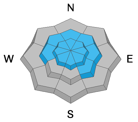
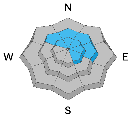
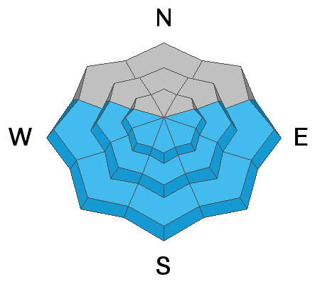
Avalanche conditions in the Provo mountains continue to be complex and dangerous. Areas of CONSIDERABLE danger still exist in the mid and upper elevations for artificially (human/cornice) triggered avalanches stepping down into older weaker layers 2-6' deep. Increasing southwest winds will allow for sensitive wind drifts in steep slopes where some may be triggered at a distance. Last but not least, the danger for wet avalanches will rise in lockstep with direct sun and daytime warming.
Big Picture: With strong wind, warming temps and heavy dense snow in the coming days, the danger will be on the rise.
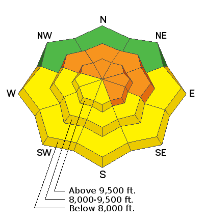
Low
Moderate
Considerable
High
Extreme
Learn how to read the forecast here
Special Announcements
There have now been four avalanche fatalities in four weeks in Utah. Yesterday, UAC staff investigated the avalanche that took the life of 49 year old Jason Lyman. Find the avalanche report HERE.
Weather and Snow
Skies are mostly clear with a few thin streamers passing overhead. Temps are already at 24 hour highs in the upper teens. Winds backed to the southwest overnight and are blowing 10-15mph with gusts to 25. Skiing and riding conditions have been quite good with excellent coverage at all elevations.

A complex series of storms will affect northern Utah tomorrow through late weekend with upwards of 2-3' possible in favored terrain. We initially start with a warm front with a rain/snow line rising to perhaps 7-7500' by Thursday then lowering back to the valley by later Friday. Heavy dense snow, strong west to southwest winds and rising temps will create dangerous avalanche conditions in the coming days.
Recent Avalanches
No new avalanches were reported in the Provo area backcountry yesterday. There was an excellent report from the area on Saturday found HERE.
Ad
Avalanche Problem #1
Wind Drifted Snow
Type
Location
Likelihood
Size
Description
Increasing southwest winds will create touchy wind drifts in some areas today with the slight chance of remote triggering. Drifts will be more prominent in the mid to upper elevation northerly to easterly aspects but more widespread as the day advances. If you start to see plumes and wind drifted snow in the open terrain, head for the shelter of the low angle trees for the better and safer skiing and riding. Watch for cracking and variable snow conditions - some clues for potential rising hazard.
Avoid being on and beneath the heavily corniced ridgelines like your life depends on it. These monsters break well back from the ridgeline and may trigger avalanches on slopes below.
Avalanche Problem #2
Persistent Weak Layer
Type
Location
Likelihood
Size
Description
There are two persistent weak layers of concern.
1. Weak surface snow and patches of surface hoar were buried Saturday February 6th are slowly strengthening. Yes, we are seeing these layers gain strength. However, we just received another load of new snow with strong winds. It remains possible one could still be trigger an avalanche on this layer. It would be 2-4' deep, most likely on a wind drifted northwest to easterly facing slope, with elevations from 8500' to 10,500'. Slides failing on faceted weak layers can be triggered from a distance, including from below.
2. Isolated but dangerous avalanches may step down 3-6' deep into older buried weak layers. While more likely to occur on slopes that have avalanched previously, two of last Friday’s explosive triggered slides were on slopes that had not slid this winter. These deep slides may require more of a significant trigger, perhaps a wind slab stepping down or cornice fall.
Avalanche Problem #3
Wet Snow
Type
Location
Likelihood
Size
Description
Much warmer temps and direct sun will create damp and unstable wet avalanche conditions on the steepest sun-exposed slopes with natural sluffs likely today. Classic tell-tale signs include pinwheels and rollerballs and wet "tree-bombs" with the thaw cycle. By afternoon, human triggered sluffs will be likely but avoidable.
General Announcements
This information does not apply to developed ski areas or highways where avalanche control is normally done. This forecast is from the U.S.D.A. Forest Service, which is solely responsible for its content. This forecast describes general avalanche conditions and local variations always occur.