Forecast for the Provo Area Mountains

Trent Meisenheimer
Issued by Trent Meisenheimer for
Monday, February 11, 2019
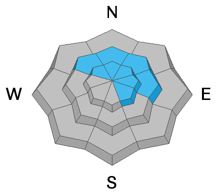
The avalanche danger is CONSIDERABLE on and below steep, wind drifted slopes at all upper elevations, as well as mid elevation northwest through east facing slopes. Human triggered avalanches are likely and natural avalanches may be possible. Dangerous avalanche condidtions.
  1. New and old wind drifts can be triggered on all steep mid and upper elevation slopes.
  2. Avoid being below any steep terrain. Avalanches can travel long distances and hit you from above.
  3. Watch for new snow soft slabs and sluffs in steep terrain.
  4. There remains the chance of triggering a deeper avalanche, especially in shallow snowpack areas.
Seek out non wind-drifted terrain . Wind sheltered, low and mid elevation terrain has a MODERATE danger, and much better turning conditions.
Low
Moderate
Considerable
High
Extreme
Learn how to read the forecast here
Special Announcements
There have now been four avalanche fatalities in four weeks in Utah. Yesterday, UAC staff investigated the avalanche that took the life of 49 year old Jason Lyman. Find the avalanche report HERE.
Weather and Snow
Yesterday, the brutal southwest winds finally gave way as a classic Utah cold front sliced over northern Utah around 3:00 pm. Winds switched to the northwest and snow began falling in the afternoon. 24 hour storm totals are 4-8" of snow (0.3-0.50" h20)
Winds this morning are from the west-north-west and currently blowing 5-15 mph with gusts into the 20's across the highest peaks and ridge lines. Mountain temperatures are frigid with upper elevation thermometers reading in the single digits °F.
For today, we will see increasing clouds at times and may be some clearing mid morning before the clouds build back in. Winds will back to more of a westerly direction and should be well behaved with speeds in the 10-20 mph range at upper elevations. Temperatures will warm into the low to mid 20's °F. Light snow is possible in favored locations but, not adding up to much. At times the sparkly magic show will begin as the sun lights up the low density six sided dendrites falling from the atmosphere.
Recent Avalanches
No new avalanches were reported in the Provo area backcountry yesterday. There was an excellent report from the area on Saturday found HERE.
Ad
Avalanche Problem #1
Wind Drifted Snow
Type
Location
Likelihood
Size
Description
Southerly winds wreaked havoc on the mountains yesterday. Upper elevation averages were in the 20-25 mph range with gusts into the 40's and 50's. To complicated the issue, all of yesterday's wind drifts are now buried and impossible to see due to the overnight storm snow. My advise would be to avoid all steep mid and upper elevation slopes for today and let the snow settle and gain some strength.
Today's, winds will be strong enough to grab the storm snow and form new drifts of wind blown snow and start forming new slab avalanches. Look for and avoid any new drifts of wind blown snow. If the snow is cracking under your skis, board or sled, this is a sign of instability.
Avalanche Problem #2
Persistent Weak Layer
Type
Location
Likelihood
Size
Description
There are two persistent weak layers of concern.
1. Weak surface snow and patches of surface hoar were buried Saturday February 6th are slowly strengthening. Yes, we are seeing these layers gain strength. However, we just received another load of new snow with strong winds. It remains possible one could still be trigger an avalanche on this layer. It would be 2-4' deep, most likely on a wind drifted northwest to easterly facing slope, with elevations from 8500' to 10,500'. Slides failing on faceted weak layers can be triggered from a distance, including from below.
2. Yesterday's wind and new snow continue to load the deep weak layers in the snowpack, layers which continue to produce isolated avalanches down near the ground 3-6' deep. While more likely to occur on slopes that have avalanched previously, two of last Friday’s explosive triggered slides were on slopes that had not slid this winter. These deep slides may require more of a significant trigger, perhaps a wind slab stepping down or cornice fall.
General Announcements
This information does not apply to developed ski areas or highways where avalanche control is normally done. This forecast is from the U.S.D.A. Forest Service, which is solely responsible for its content. This forecast describes general avalanche conditions and local variations always occur.