UDOT PLANNED AVALANCHE CLOSURES!!

Forecast for the Provo Area Mountains

Greg Gagne
Issued by Greg Gagne for
Wednesday, February 13, 2019
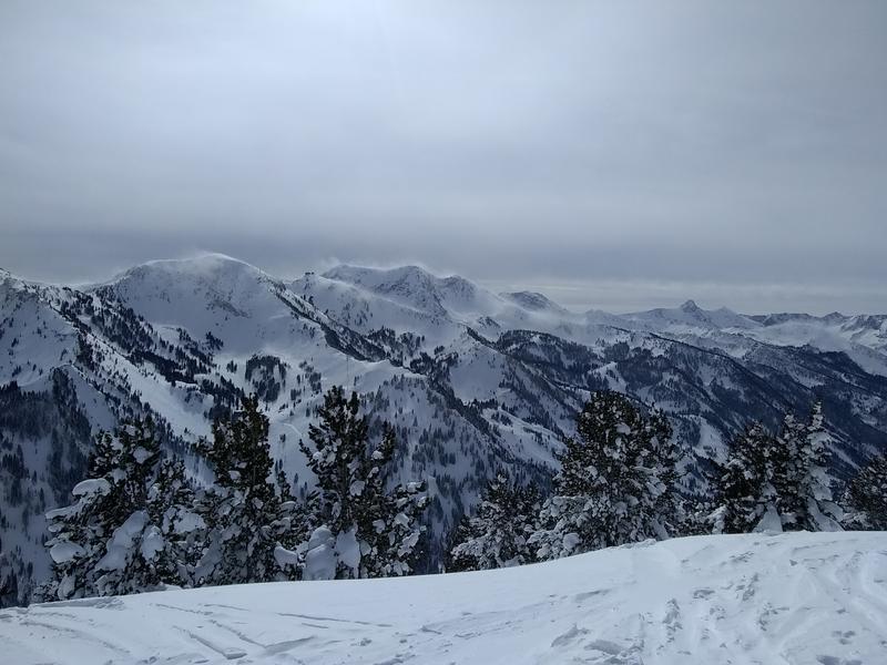
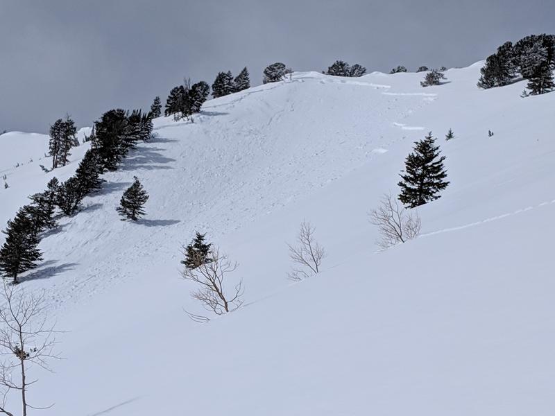
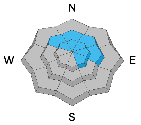
It is a day of rising danger, with the avalanche hazard reaching CONSIDERABLE by this afternoon at mid and upper elevations facing west, through north, and east. The primary avalanche concern are recent and new wind slabs at the mid and upper elevations. Cornices are also growing and may break off naturally. Avoid traveling on a slope beneath cornices, and stay well back from a corniced ridgeline. Possible rain on snow at lower elevations add to the list of avalanche concerns, as well as sluffing in the new snow and shallow, sensitive storm slabs that may develop during any period of higher precipitation intensity.
The avalanche hazard will likely rise to HIGH by later this week, with elevated avalanche hazard through at least the holiday weekend.
Low
Moderate
Considerable
High
Extreme
Learn how to read the forecast here
Avalanche Watch
The Utah Avalanche Center has issued an Avalanche Watch for all the mountains of northern and central Utah, including the Bear River and Wasatch Range, the western Uintas, and the Manti Skyline. Strong winds and heavy dense snow, with rain-on-snow at lower elevations will create dangerous avalanche conditions. Natural and human-triggered avalanches will be likely by later Wednesday and into Thursday morning. This watch is expected to be elevated to a warning by Thursday morning.
Special Announcements
There have now been four avalanche fatalities in four weeks in Utah. On Sunday, UAC staff investigated the avalanche that took the life of 49-year-old Jason Lyman. Find the avalanche report HERE.
Weather and Snow
Temperatures are in the in the teens and 20’s F, but it’s the winds grabbing the headlines with strong south/southwest winds, gusting in the 40’s mph at around 9500’, 50’s at 10,000', and 60’s and 70’s at 11000'. No new snow has been recorded overnight in the Provo mountains. Photo below showing strong winds in upper elevation alpine terrain of American Fork/Little Cottonwood ridgeline
Additional snowfall for today, especially this afternoon, with 1-3” possible by later today. Winds will continue to blow out of the southwest, averaging in the 20’s mph at mid elevations and 30’s at upper elevations. Gusts will be in the 40’s at mid elevations, and 60’s at upper elevations. Temperatures will be in the 20’s F.
Rain at lower elevations will be possible, with a rain/snow line hovering at about 7000'.
Strong winds and heavy, dense snow is forecasted overnight into Thursday, with significant accumulations possible. Temperatures will be warming on Thursday, with a rising rain/snow line.
Expect rising avalanche hazard over the next few days, with an elevated hazard persisting through the holiday weekend.
Recent Avalanches
A wind slab avalanche was reported from Tuesday in the Provo mountains. This was on a cross-loaded east/northeast slope at 10,500'. The wind slab was 2-3' deep, 150' wide, and ran 1000' vertical. (Observation)
One Cottonwood resort pulled out a very large slide just below 11,000’ with control work. This was on steep upper elevation NE aspect that had been wind-loaded. The crown was 8-10’ deep and it ran over 1000’ vertical.
Ad
Avalanche Problem #1
Wind Drifted Snow
Type
Location
Likelihood
Size
Description
Strong winds will create dense drifts today at the mid and upper elevations. Although winds are out of the south/southwest, such strong winds can work through terrain, and cross-load almost any aspect. Watch for obvious signs of wind-loading such as smooth, rounded pillows. Yesterday's slide on Freedom Peak ridgeline is an excellent example of what you can expect today.
Several observers have noted the increasing sizes of cornices along upper elevation ridgelines. Cornices will continue to grow today, so be sure to stay well-back from the ridge lines as cornices could break back much further than expected. Also avoid traveling below any cornices as fresh drifting along cornices may break off naturally. [Photo: Zimmerman-Wall]
Avalanche Problem #3
Persistent Weak Layer
Type
Location
Likelihood
Size
Description
There are two persistent weak layers of concern.
1. Weak surface snow and patches of surface hoar that were buried Saturday, February 2nd, and are now buried about 3' deeply. Stability tests are indicating this layer is gaining strength, however wind drifts and new storm snow will stress to the snowpack, and triggering an avalanche on this layer remains possible. The terrain of greatest concern are steeper, wind-drifted slopes facing northwest through east, generally above 8500'. Slides failing on faceted weak layers can be triggered from a distance, including from below on lower angle slopes.
2. Recent wind-loading and today's forecasted winds and new snow continue to load the deep weak layers in the snowpack; layers which continue to produce isolated avalanches down near the ground 3'-6' deep. These deep slides may require more of a significant trigger, perhaps a wind slab stepping down or large cornice fall. While more likely to occur on slopes that have avalanched previously ("repeaters"), two of last Friday’s explosive triggered slides were on slopes that had not slid this winter. Additionally, areas with a traditionally shallower snowpack such as Neffs, Lambs, parts of Mill Creek, and the Park City ridgeline are also more suspect for these deeper avalanches.
General Announcements
This information does not apply to developed ski areas or highways where avalanche control is normally done. This forecast is from the U.S.D.A. Forest Service, which is solely responsible for its content. This forecast describes general avalanche conditions and local variations always occur.