UDOT PLANNED AVALANCHE CLOSURES!!

Forecast for the Provo Area Mountains

Trent Meisenheimer
Issued by Trent Meisenheimer for
Saturday, February 11, 2023
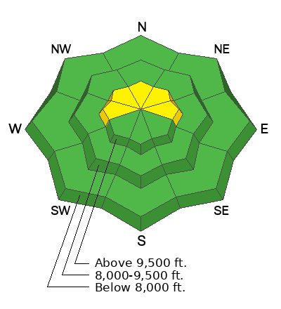
The avalanche danger is MODERATE on upper elevation slopes facing west to north and east for wind-drifted snow avalanches. Here it is possible to trigger a hard or soft wind slab 6-18 inches deep and up to 100 feet wide. Human-triggered avalanches are possible.
If, for any reason, the sun comes through the clouds and the temperatures are warmer than expected and the snow surface becomes wet, we should be thinking of wet snow avalanche issues. This includes north-facing terrain.
Low
Moderate
Considerable
High
Extreme
Learn how to read the forecast here
Weather and Snow
This morning, mountain temperatures range from 20-32°F. Winds are southwest at 15-30 mph, gusting into the 40s & 50s across the upper elevations. The skies are mostly cloudy as a large cut-off low digs south along the Pacific Coast. This cut-off low will usher in southerly winds, warming temperatures, and thin high to mid-elevation clouds. Temperatures will climb into the low to mid-30s °F.
The good news is the winds have already peaked, and they should die off almost entirely later today as the storm moves south (as shown by the graph below). The bad news is this storm will produce no precipitation for us, and our next hope for new snow will be Tuesday.
Snow surfaces have taken a beating from the sun and wind. However, one can still find soft, settled powder in sheltered locations.
Recent Avalanches
No new avalanches were reported from the Provo area. Yesterday's avalanche activity in the Wasatch revolved mainly around the strong sunshine and warming temperatures. We had three avalanches reported, one in Hogum Fork where a rider was briefly caught and carried in a wet slab avalanche on a SE-facing slope at 10,600 feet in elevation. The avalanche was 18 inches deep and 100 feet wide, running 500 feet down the hill.
The second was in the Session Mountains, where a wet loose avalanche ran down and almost hit the skier. The third was a wind slab on Little Superior that was 3 inches deep and 60 feet wide.
Ad
Avalanche Problem #1
Wind Drifted Snow
Type
Location
Likelihood
Size
Description
Pockets of wind-drifted snow 6-18" thick can be found on northerly-facing slopes at the upper elevations. Strong southerly winds overnight and into this morning could keep old wind slabs sensitive to the weight of riders as well as develop some fresh new wind drifts.
Hot tip: if you're on a ridgeline toss a snowball into the slope; if it lands in powder and sinks in, there is no wind slab; if it lands on a hard surface breaking the snowball there is probably a wind slab, and you should find another way into the slope. Avoid the wind-drifted snow, and you'll avoid the avalanche problem today.
Additional Information
Check out the updated guidance on electronic interference and beacons HERE. The "20/50 Rule" is that you want your beacon 20cm (8") away from other electronics while transmitting and 50cm (20") away from electronics while searching.
General Announcements
This information does not apply to developed ski areas or highways where avalanche control is normally done. This forecast is from the U.S.D.A. Forest Service, which is solely responsible for its content. This forecast describes general avalanche conditions and local variations always occur.