UDOT PLANNED AVALANCHE CLOSURES!!

Forecast for the Provo Area Mountains

Evelyn Lees
Issued by Evelyn Lees for
Saturday, December 8, 2018
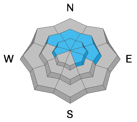
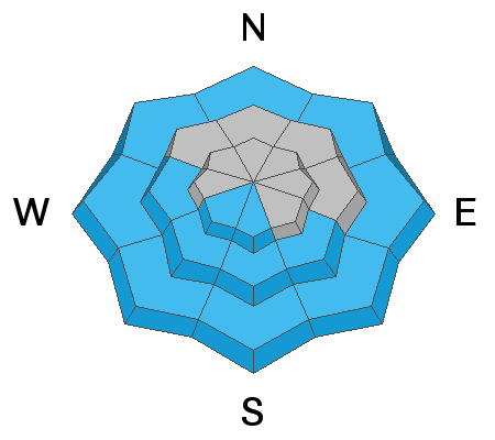
The avalanche danger is CONSIDERABLE on upper elevation slopes facing northwest through easterly, where a slide could break 2 to 4 feet deep, failing near the ground on weak, sugary facets. On these same shady, mid elevation slopes and upper elevation westerly and southeasterly facing slopes, the avalanche danger is MODERATE. Here, the likelihood of triggering a slide is less, though it would still break near the ground.
In Utah, we can live and die by aspect, use a compass to precisely nail down the direction a slope faces.
Low
Moderate
Considerable
High
Extreme
Learn how to read the forecast here
Weather and Snow
In the Provo area mountains, temperatures are in the mid to upper 20s this morning, and southwesterly winds very light, averaging 5 to 10 mph at all elevations. Skies will remain mostly cloudy for the day, with a dusting of fresh snow possible as a weak disturbance moves by to the north. Winds across the high ridge lines will increase, into the 15 to 25 mph range. A high pressure ridge moves in on Sunday, and by Monday, 9000’ temperatures will warm to near 40. The next chance for a shot of snow is around Wednesday.
Snow depths in the Provo area mountains measure 24 to 33" at the various snow stakes, at elevations of 6800 to 8800'. Sunny slopes are all crusted, but decent settled powder remains on the shady slopes. Coverage remains thin at the lower elevations, though roads are mostly snow packed.
Recent Avalanches
No new avalanches reported from the Provo area mountains, so here is information from the Salt Lake area mountains, which have a similar snow pack. Yesterday, avalanches breaking on facets near the ground were released with explosives in Big and Little Cottonwood. They were on north through east facing slopes, between 10,000 and 10,500 feet. Yesterday and Thursday, there were continued reports of collapsing in the backcountry, including one on a west-facing slope at 9,000.
Ad
Avalanche Problem #1
Persistent Weak Layer
Type
Location
Likelihood
Size
Description
Again, from the Salt Lake area mountains:
Upper elevation slopes facing north and northeast remain the bull-eye terrain for harboring weak faceted snow, and are where dozens of avalanches have been triggered in the backcountry or at resorts. The faceted snow near the ground, and it formed when a shallow layer of October and pre-Thanksgiving snow sat around for weeks. Trent and Randy Sugahara were out riding yesterday in the Tibble Fork and Mill Canyon Peak area, and avoided all north facing slopes.
The pattern is more complex on the mid elevation shady slopes and on upper elevation NW, W, E and SE facing slopes, with some slopes lacking facets and others having large collapses and recent avalanches. If you want to go steep on these slopes, do some research - find a representative lower angle slope, get out your shove and dig down to the ground, looking for facets. Below is a great video by Quinn Graves and Bo Torrey showing unstable results on a northeast-facing slope at 8,500’, indicating stay off steep slopes of a similar aspect and elevation.
The past week’s avalanche roses illustrates how “persistent” or slow to strengthen the weak layer is.
Avalanche Problem #2
Normal Caution
Type
Location
Likelihood
Size
Description
Terrain without old faceted snow near the ground has a mostly low avalanche danger, but small avalanches can be triggered in isolated places – perhaps a newly formed wind drift along a high ridge line as the winds speeds increase today, or a sluff on a very steep, northerly facing slope. Terrain that’s super steep or has cliffs, trees or gullies below you has higher consequences if you are caught in even a small slide
General Announcements
This information does not apply to developed ski areas or highways where avalanche control is normally done. This forecast is from the U.S.D.A. Forest Service, which is solely responsible for its content. This forecast describes general avalanche conditions and local variations always occur.