Forecast for the Provo Area Mountains

Trent Meisenheimer
Issued by Trent Meisenheimer for
Sunday, December 9, 2018
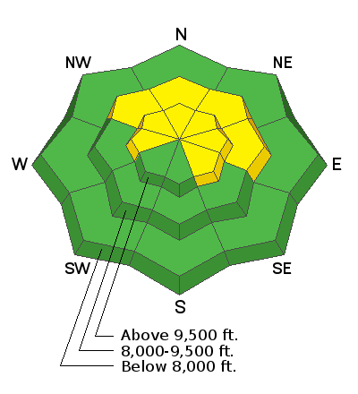
The avalanche danger is MODERATE on upper elevation slopes facing west through southeast, and on mid elevation northwest through east facing terrain. Don't let MODERATE danger fool you! it's still possible to trigger an avalanche 2-4' feet deep that has potential to kill you. Yes, the likelihood of triggering a slab avalanche has gone down, but the consequence remains the same. South facing terrain was spared the persistent weak layer and you'll find a LOW danger on those slopes.
Low
Moderate
Considerable
High
Extreme
Learn how to read the forecast here
Weather and Snow
We have a short wave ridge building into northern Utah this morning. This will lead to clear and sunny skis in the mountains today. Current mountain temperatures are in the mid teens °F at upper elevation stations. Winds across the highest ridge lines are calm. The snow surface remains excellent with dense soft settled powder on the shady aspects. The southerly facing aspects will support a crust that will likely become soft by the afternoon.
We will see a quick hitting storm that will pass overhead Monday evening into Tuesday bringing a few inches of new snow with it. The best chance for a decent shot of snow happens mid-week as a stronger system crosses northern Utah Wednesday into Thursday. We can expect a decent re-fresh of snow within the 4-8" range. Hats off to professor Jim Steenburgh for teaching me about synoptic mountain meteorology this semester. If you like weather and snow snobbery follow his blog HERE.
Photo: 500 millibar geo-potential heights. This shows the storm we have coming in for Wednesday/Thursday this coming week.
Recent Avalanches
Yesterday, in the SLC area mountains a skier took a ride in an avalanche in upper Porter Fork just east of the Ice Box in Millcreek Canyon. The avalanche failed on the second skier when they were 100' feet down on their run. The skier was dragged through some trees before coming to rest with head and arms above the snow and facing downhill. The skier did sustained injuries. The group did a good job self evacuating and getting down on their own power. Drew Hardesty will be visiting the site today and will hopefully have more snowpack information this evening. Link to the preliminary accident report. Found HERE. No Provo observations were submitted yesterday.
Here is the list of all recent observations found HERE.
Ad
Avalanche Problem #1
Persistent Weak Layer
Type
Location
Likelihood
Size
Description
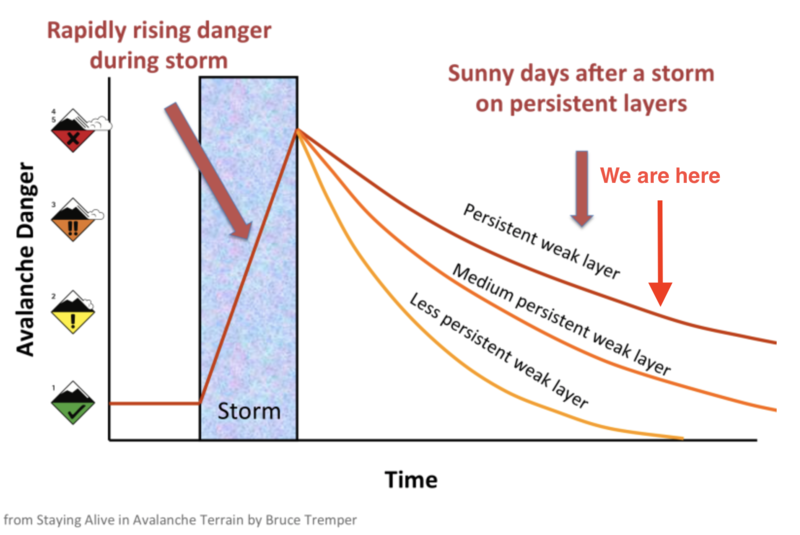
Upper elevation slopes facing northwest through east will remain the bulls-eye terrain for triggering a slab avalanche that fails on weak faceted snow. Unfortunately, this persistent weak layer takes a long time to heal. As time goes on, the bulls-eye clues like avalanches, cracking and collapsing go away as the snowpack slowly adjusts to it's recent load of storm snow. Don't let that fool you - it's still possible to trigger an avalanche 2-4' feet deep that has potential to kill you. Yes, the likelihood of triggering a slab avalanche has gone down, but the consequence remains the same.
If you find your-self in northerly facing terrain continue to watch your slope angles as well as what terrain is above you. Avoid steep, rocky terrain that is most likely to avalanche. I love riding powder as much as the next person, but right now is not the time to be riding steep exposed lines, especially ones that have old weak snow underneath. Even though the avalanche danger is MODERATE today - you won't find any of the forecasters at the UAC riding steep northerly facing terrain. We will continue to be patient and wait for the snowpack to become more stable.
Photo: From Bruce Tremper's book. It shows how the danger of a persistent weak layer slowly decreases over time. I put an arrow in to show you where we sit currently.
Additional Information
Join forecaster Craig Gordon this Tuesday December 11th at the Park City Library to learn about the " Current state of the snowpack... how did we get here? and where are we going." 1255 Park Avenue, park City, Utah. 6:30pm.
General Announcements
This information does not apply to developed ski areas or highways where avalanche control is normally done. This forecast is from the U.S.D.A. Forest Service, which is solely responsible for its content. This forecast describes general avalanche conditions and local variations always occur.