Forecast for the Provo Area Mountains

Nikki Champion
Issued by Nikki Champion for
Thursday, December 7, 2023
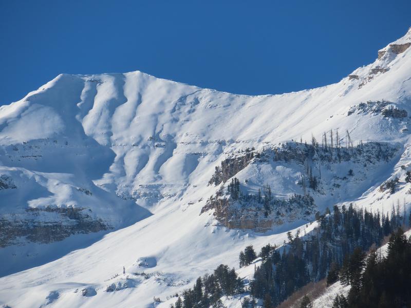
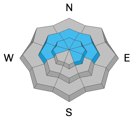
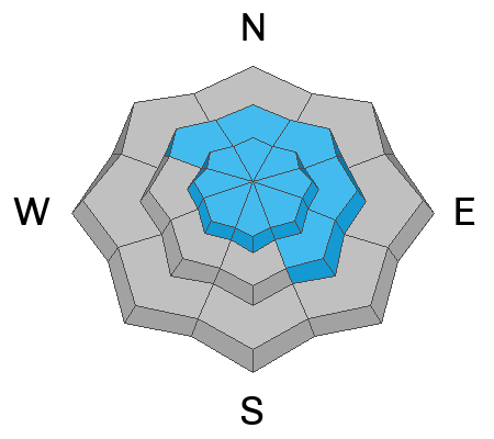
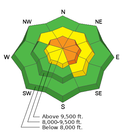
Avalanche danger is CONSIDERABLE on steep upper-elevation slopes facing northwest through north to southeast. Natural and human-triggered avalanches may break 2-5 feet deep and span several hundred feet wide, failing on a persistent weak layer of faceted snow. These are dangerous avalanche conditions. A MODERATE danger exists on the remaining upper and mid-elevation slopes facing northwest through north to southeast.

The north-facing slopes harboring old, weak faceted snow surfaces are not to be messed with. Careful snowpack evaluation, cautious route-finding, and conservative decision-making will be essential today.
Low
Moderate
Considerable
High
Extreme
Learn how to read the forecast here
Special Announcements
The 5th Annual Avalanche Awareness Week is December 3-10. The week's goal is to save lives through activities that promote avalanche awareness, education, and safety. We have a variety of events around the state. Find an event near you.
Weather and Snow
This morning, the skies are overcast, and it is snowing lightly in the mountains. As of 5 AM, there is no measurable accumulation. Temperatures are in the low-40s F at trailheads and mid to low 30s F at ridgelines. Winds are west-southwesterly and average 20-40 mph at mid-elevations; winds average 30-50 mph at uppermost elevations, with gusts near 70 mph.
A storm system brushing northern Utah today will bring light snow to the area through this afternoon. Anticipate total accumulations of 1 inch with this initial storm. Temperatures will remain in the mid and upper 30s F. The southwesterly winds will transition more westerly and gradually decrease with the incoming snowfall, the mid-elevation ridgeline winds will average 10-20 mph, gusting up to 40 mph, and the highest ridgeline winds will average 25-35 mph with gusts up to 55 mph.
A more substantial, potent storm will arrive tonight, bringing intensified precipitation from 2–7 AM Friday. Ridgetop winds, initially strong, diminish as snowfall ensues, gradually easing through the day. Final snow totals by Saturday morning should be 6-12” for the Provo area mountains.
Yesterday, along the Park City Ridgeline, Drew noted that snow surfaces had developed 2-5mm surface hoar, diurnal facets on the shady aspects, and a thin layer of radiation recrystallization facets on southerly aspects. I am unsure if these same surface features developed in the Provo area mountains; this will be something worth looking for and then watching to see if they are preserved after last night into this next storm. While none of these are an issue on the snow surface, they can become an issue if kept and buried within our snowpack.
Photo of the thin layer of radiation recrystallization facets on the surface.
Recent Avalanches
Overall, avalanche activity in the backcountry has begun to decrease. Yesterday, we did get a report of one skier-triggered slab of wind-drifted snow in Scott’s Bowl, along the Park City Ridgeline, on a Northeast aspect near 9700’. This slab broke 18" deep and approx 30' wide.
Over the past few days, we went through a large natural avalanche cycle throughout the mountains of northern Utah. Control work produced large and destructive avalanches breaking 2-5 feet deep and up to 1,000 feet wide, taking out trees and running into the flats. In the backcountry, reports of remotely triggered slides and all the natural avalanche activities from the storm cycle continue to pour into our observation cue. Provo went through a pretty impressive cycle. Huge shout out to Woody for submitting close to 15 of those avalanches to our observation page. Be sure to check it out.
Photo: Example of the widespread avalanche activity we are dealing with. White Limbo - Cascade Mountain
Ad
Avalanche Problem #1
Persistent Weak Layer
Type
Location
Likelihood
Size
Description
At mid to upper elevations on north-facing slopes and upper elevations on southeast-facing slopes, the snowpack’s base consists of weak, faceted snow from the early October/November storms.
This weak-faceted has now been buried under wind-drifted snow in upper-elevation terrain and capped by lingering new snow in wind-protected areas. In areas where the wind has loaded the slope, the slab could be anywhere from 2-5 feet deep and several hundred feet wide. These conditions are challenging, and while the likelihood of triggering an avalanche on this layer has decreased over the last day or two, the consequences remain just as high.
Personally, I will continue to avoid any steep northwest through north through southeast facing terrain at the upper elevations, with any steep terrain above or attached. Though this layer is getting harder to trigger, today is not the day to push it. This persistent weak layer is not going anywhere fast; the best way to handle it is to avoid it. Stick to low-angle terrain.

These types of avalanches are the ones that catch, carry, and kill the most backcountry recreationalists.
Avalanche Problem #2
Wind Drifted Snow
Type
Location
Likelihood
Size
Description
Southwesterly winds were cranking overnight, with gusts near 50 mph. These elevated winds, combined with some lingering soft snow, and the potential for new snow today, is the perfect recipe for wind-drifted snow avalanches.
What to do? Look for evidence of fresh drifts and wind slabs that look wavy, rounded, smooth, and pillow, and avoid them.
Any wind slab avalanche that you trigger has the potential to step down into deeper weak layers in the snowpack, creating a large, dangerous avalanche.
General Announcements
This information does not apply to developed ski areas or highways where avalanche control is normally done. This forecast is from the U.S.D.A. Forest Service, which is solely responsible for its content. This forecast describes general avalanche conditions and local variations always occur.