Forecast for the Provo Area Mountains

Nikki Champion
Issued by Nikki Champion for
Wednesday, December 6, 2023
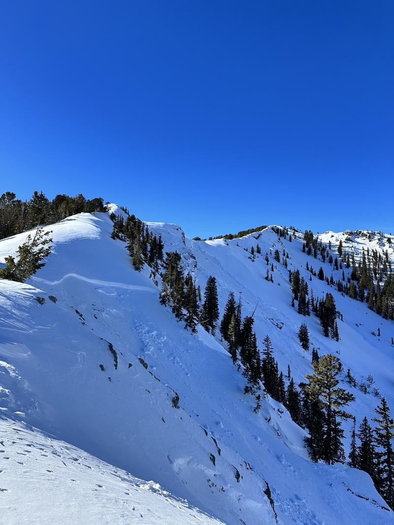
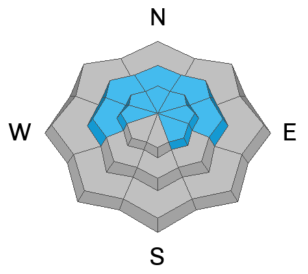
Avalanche danger is CONSIDERABLE on steep upper-elevation slopes facing west through north to southeast and on steep mid-elevation slopes facing west through north to east. Natural and human-triggered avalanches may break 2-5 feet deep and span several hundred feet wide, failing on a persistent weak layer of faceted snow. There is a MODERATE danger on the remaining upper and mid-elevation slopes. The low-elevation slopes have a LOW danger.

The north-facing slopes harboring old, weak faceted snow surfaces are not to be messed with. Avoid slopes 30° degrees and steeper at mid and upper elevations where this weak snow exists.
Low
Moderate
Considerable
High
Extreme
Learn how to read the forecast here
Special Announcements
Please be aware of uphill travel policies at the ski areas and respect their closures to keep you and their workers safe.
The 5th Annual Avalanche Awareness Week is December 3-10. The week's goal is to save lives through activities that promote avalanche awareness, education, and safety. We have a variety of events around the state. Find an event near you.
Weather and Snow
This morning, skies are clear with an inversion in the mountains. Temperatures are in the low-40s F at the highest elevations and mid-20s F at the trailheads. Winds are south-southwesterly and average 5-10 mph at mid-elevations; winds average 15-20 mph at uppermost elevations, with gusts near 30 mph.
Today should be another beautiful day in the mountains. Skies will remain mostly clear and become sunny, with high clouds increasing in the afternoon. Temperatures will be warm again, climbing into the upper 30s and low 40s F. The southwesterly winds will gradually increase throughout the day, the mid-elevation ridgeline winds will average 15-25 mph, gusting up to 30 mph, and the highest ridgeline winds will pick up to 25-35 mph with gusts up to 60 mph.
We can expect light snow from a passing storm in northern Utah late tonight into tomorrow, bringing around 1-4 inches of snow. After a short break tomorrow evening, a more robust, colder storm is coming Thursday night into Friday with more significant, lower-density snowfall. Stay tuned for updates on changing weather conditions.

With a break in the weather, let us get a final look at the impressive snow and water totals from the past weekend:
  • Provo area mountains: 20-30” snow (1.58-2.25” water)
Recent Avalanches
Avalanche activity has been nothing short of terrifying and electric. Over the past few days, we've gone through a large natural avalanche cycle throughout the mountains of northern Utah. Control work continues to produce many large and destructive avalanches breaking 2-5 feet deep and up to 1,000 feet wide taking out trees and running into the flats. In the backcountry, reports of large remotely triggered slides, as well as all the natural avalanche activity, keeps pouring into our observation cue. Be sure to check it out.
Photo: Example of the widespread avalanche activity we are dealing with.
Ad
Avalanche Problem #1
Persistent Weak Layer
Type
Location
Likelihood
Size
Description
In mid to upper elevations on northerly-facing terrain and at upper elevations on southeast-facing terrain, weak faceted snow from the early October/November storms makes up the base of our snowpack.
This weak faceted snow has now been buried under wind-drifted snow in upper-elevation terrain and capped by new snow in wind-protected mid-elevation areas. In areas where the wind has loaded the slope, the slab could be anywhere from 2-5 feet deep and several hundred feet wide. We have dangerous avalanche conditions, and you could easily trigger a season-ending slab avalanche failing on this persistent weak layer.
Given the recent snowfall, elevated winds, and poor snowpack structure, I would avoid any steep west through north through southeast facing terrain at mid and upper elevations, with any steep terrain above or attached. Though this layer is getting harder to trigger, today is not the day to push it. This persistent weak layer is not going anywhere fast; the best way to handle it is to avoid it. Stick to low-angle terrain.

Here are a few things to remember when dealing with a persistent weak layer issue:
  • Avalanches can be triggered from a distance, adjacent terrain, or even from the flats.
  • Tracks on a slope do not mean stability. Do not let tracks lure you into avalanche terrain.
  • These types of avalanches are the ones that catch, carry, and kill the most backcountry recreationalists.
Avalanche Problem #2
Wind Drifted Snow
Type
Location
Likelihood
Size
Description
Southwesterly winds will climb throughout the day and evening, with peak gusts up to 60 mph. These elevated winds and recent snowfall are the perfect recipe for wind-drifted snow avalanches. These avalanches could be 2-5 feet deep and hundreds of feet wide.
What to do? Look for evidence of fresh drifts and wind slabs that look wavy, rounded, smooth, and pillow, and avoid them.
Any wind slab avalanche that you trigger has the potential to step down into deeper weak layers in the snowpack, creating aa huge, dangerous avalanche.
General Announcements
This information does not apply to developed ski areas or highways where avalanche control is normally done. This forecast is from the U.S.D.A. Forest Service, which is solely responsible for its content. This forecast describes general avalanche conditions and local variations always occur.