Forecast for the Provo Area Mountains

Trent Meisenheimer
Issued by Trent Meisenheimer for
Monday, December 4, 2023
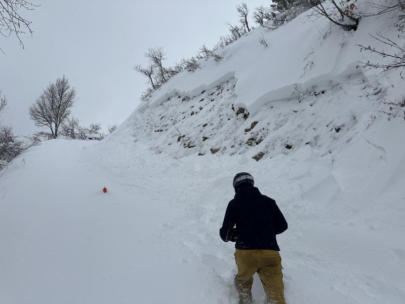
The avalanche danger is HIGH on steep slopes across the mid and upper elevations. The danger is CONSIDERABLE on many steep slopes. Today's travel advice is straightforward: TRAVELING IN AVALANCHE TERRAIN IS NOT RECOMMENDED. This includes being below avalanche terrain.

TODAY AND TOMORROW HAS AVALANCHE ACCIDENT/FATALITY WRITTEN ALL OVER IT. PLEASE AVOID AVALANCHE TERRAIN!
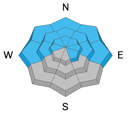
Low
Moderate
Considerable
High
Extreme
Learn how to read the forecast here
Special Announcements
Please be aware of uphill travel policies at the ski areas and respect their closures to keep you and their workers safe.
The 5th Annual Avalanche Awareness Week is December 3-10. The week's goal is to save lives through activities that promote avalanche awareness, education, and safety. We have a variety of events around the state. Find an event near you.
Weather and Snow
Under cloudy skies, our epic storm is finally coming to a close. Current mountain temperatures range from 30-32°F. Winds have finally relaxed and are blowing from the northwest at 5-15 mph across the upper-elevation terrain. At 11,000', the winds are a bit stronger and blow northwest at 30-35 mph gusting into the 40s mph. In the past 24 hours, we've received another 2-8 inches of new snow containing roughly 0.24-1.11 inches of water.
This morning the last snowflakes fall (hopefully not rime). This afternoon, we should see partly to clearing skies by the end of the day as high pressure sets in. Temperatures will climb into the mid to low 30s °F at 8,500'. Winds will remain from the northwest and blow at speeds of 5-15 mph across the upper elevations. Storm totals are as follows:
Upper Cottonwoods: 40-50" snow (3.83-4.66" water)
Park City Ridgeline: 20-30" snow (1.80-2.58" water)
Ogden Mountains: 30-50" snow (2.85-5.0" water)
Provo Mountains: 20-30" snow (1.58-2.25" water)
Recent Avalanches
The mountains have gone through a widespread natural and human-triggered avalanche cycle within the past 24-48 hours from strong northwest winds and relentless heavy snowfall. A few backcountry riders were caught and carried short distances yesterday, and luckily, there were no injuries. There are too many avalanches to list here, so I am going to mention the top four that caught my attention. Be sure to check out the Avalanche List.
  • Upper Little Cottonwood, Flagstaff Gully. SE facing at 9,400 feet. 2.5' deep by 300' wide. One was caught and carried.
  • Upper Little Cottonwood, Suicide Chute. East facing at 9,500 feet. 10" deep by 30' wide. Three were caught and carried.
  • Big Cottonwood Canyon, East Face Reynolds Peak. East facing at 9,400 feet. 2' deep by 800' wide and ran to the flats.
  • Mill Creek Canyon, Littlewater Peak, Firewater. North facing at 9,400 feet. 3' deep by 200' wide and ran to the flats.
Photo: Hobble Creek
Ad
Avalanche Problem #1
Persistent Weak Layer
Type
Location
Likelihood
Size
Description
On northerly facing terrain, and on upper elevation southeast (see locator rose), you will find weak faceted snow at the base of our snowpack from early season October / November storms that became weak and faceted.
The past 72 hours of strong winds and heavy new snowfall have overloaded this weak foundation. Deep and dangerous slab avalanches 2-4 feet deep and hundreds of feet wide are very likely today. There is no outsmarting this problem. Let the snowpack settle and heal. I am going to make this simple:
DO NOT RIDE AVALANCHE TERRAIN TODAY (ANY SLOPE STEEPER THAN 30°).
AVOID BEING IN RUNOUT ZONES (AVALANCHES CAN RUN LONG DISTANCES).
AVALANCHES CAN BE TRIGGERED FROM A DISTANCE, ADJACENT TERRAIN, OR FROM THE FLATS.
DO NOT LET TRACKS LURE YOU INTO AVALANCHE TERRAIN. TRACKS MEAN NOTHING.
THESE ARE THE AVALANCHES THAT CATCH, CARRY, AND KILL MOST BACKCOUNTRY RECREATIONALISTS.
Avalanche Problem #2
Wind Drifted Snow
Type
Location
Likelihood
Size
Description
Northwest winds picked up roughly 72 hours ago on December 1 at 12:00 PM. These winds have blown relentlessly at 15-30 mph, gusting into the 30s and 40s across the upper-elevation terrain. These winds and heavy snowfall are the perfect recipe for Wind-Drifted Snow avalanches. These avalanches could be 2-4 feet deep and hundreds of feet wide. Watch for and avoid steep slopes that are heavily drifted.
On the shady aspects, any wind slab you trigger has the potential to step down deeper into weak faceted snow, making it a deeper, wider, and, therefore, a much more dangerous avalanche.
Avalanche Problem #3
New Snow
Type
Location
Likelihood
Size
Description
Heavy dense snowfall has blanketed the Wasatch Mountains. This heavy snow fell on very cold, low-density powder, making it upside-down. Remember, anytime we have weaker (less dense) snow with stronger, more cohesive snow above; it makes the perfect recipe for slab avalanches. Shooting cracks are a clear sign of instability.
Over the past 24 hours, warming has led to some rain and very warm and wet snow across the lower elevations and foothills. Here, it is possible to find damp, wet snow that could avalanche on steep terrain. Avoid being in gullies or confined terrain features where the snow could stack up quickly.
General Announcements
This information does not apply to developed ski areas or highways where avalanche control is normally done. This forecast is from the U.S.D.A. Forest Service, which is solely responsible for its content. This forecast describes general avalanche conditions and local variations always occur.