UDOT PLANNED AVALANCHE CLOSURES!!

Forecast for the Provo Area Mountains

Nikki Champion
Issued by Nikki Champion on
Tuesday morning, December 31, 2024
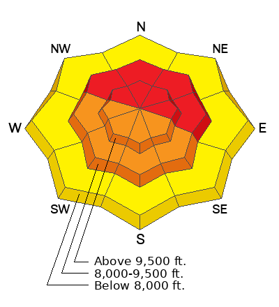
The avalanche danger is HIGH on upper and mid-elevation slopes facing northwest through north and east. New snowfall and strong winds have created very dangerous conditions. Avalanches triggered in wind-drifted or new snow could step down 1-6 feet into weak-faceted snow, resulting in large, dangerous, and potentially deadly slides. Both natural and human-triggered avalanches are likely.
With clear skies, backcountry riders may be tempted by the appealing conditions, but avalanche danger remains high. Most avalanche accidents and fatalities occur after peak instability. Fortunately, avalanche terrain can be easily avoided. Excellent riding can be found on lower-angled slopes.
What to do today:
  • Stick to slopes less than 30 degrees.
  • Stay well away from slopes connected to or below anything steeper than 30 degrees.
Low
Moderate
Considerable
High
Extreme
Learn how to read the forecast here
Avalanche Warning
What: The avalanche danger for the warning area is HIGH today
Impacts: Recent heavy snow combined with strong wind is creating widespread areas of unstable snow. Both human-triggered and natural avalanches are likely.
What to do: Avoid all avalanche terrain. Stay off of and out from under slopes steeper than 30°. Carry and know how to use avalanche rescue equipment. Find safer riding conditions on slopes less than 30° with no overhead hazard
Warning Times: Tuesday December 31, 2024 - 6:00am to Wednesday January 1, 2025 - 6:00am
Weather and Snow
This morning, skies are finally clearing, and for the first time in several mornings, it’s not snowing. Temperatures have dropped significantly since yesterday with a temperature inversion in the mountains. Trailhead and base area temperatures are near or below zero, while ridgetop temperatures are nearing the low teens. Northwesterly winds have decreased overnight and are now 0-5 mph, with gusts up to 15 mph at the highest ridgelines. Final snow totals for the Provo area since the 26th were up to 26" of snow (with 3.02" of water).
Today will be cold and sunny in the mountains. Northwesterly winds should remain light, averaging 0-15 mph, while temperatures rise into the low 20s°F.
Looking Ahead: A gradual warming trend will develop this week. A weak storm is expected to graze northern Utah Wednesday into early Thursday, bringing 1-3 inches of snow to the northern mountains. Another, potentially stronger system could arrive this weekend, bringing 6-12 inches of snow to the northern and central mountains, depending on its track and intensity.
Recent Avalanches
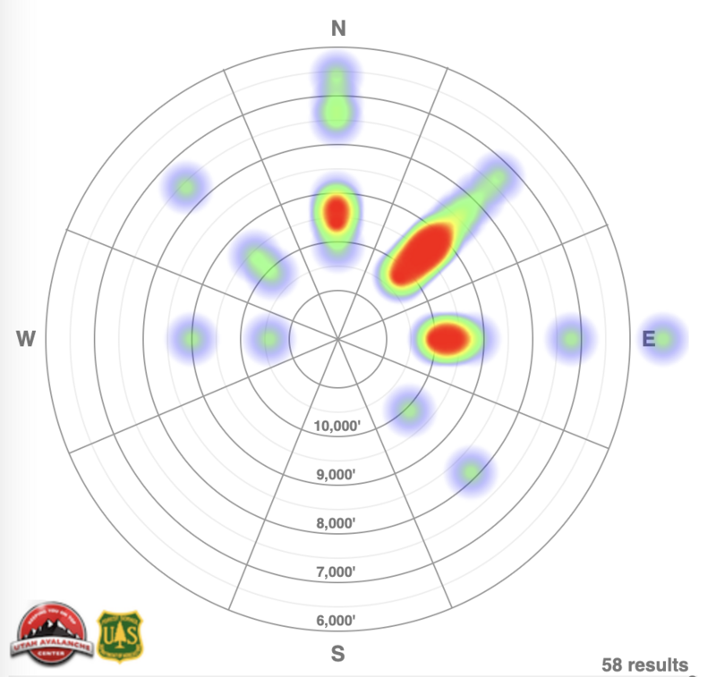
A three-part storm from December 27–29 triggered a widespread avalanche cycle across the Provo area, with strong winds, dense snow, and rain causing avalanches ranging from 10"-36" deep, 200'-2,500' wide, and up to 3,000' vertical. A rain crust formed below 8,000' after the storm. In addition to numerous avalanches reported by UDOT Provo, 58 backcountry avalanches were reported to the Utah Avalanche Center from the Salt Lake, Provo, and Ogden area mountains, with 6 occurring in the Provo area. Many of these avalanches were remotely triggered or caused by distant failures, with slides reaching multiple feet deep and over a thousand feet wide.
Notable avalanche activity included slides in Timp, such as Pika Cirque (West and Center), Bomber Bowl, the entire Timp Cirque Head Wall, The Grunge and Side Apron, Wooley Hole, NE Chute, and N Elk Chute. In Cascade Cirque, most of the area experienced avalanches, while the Provo area saw slides in Provo Hole, East Face, No Money Down, Chablis (Upper and Mid), Slide Canyon (Mid Zone), Lost Creek (Gunner's Left), and Spring Falls Chute. Bunnells experienced avalanches in White Limbo, Middle, and Bimbo, and Big Springs saw significant activity in Big Bowls 1 through 6.
Below is the avalanche heat map highlighting recent activity across the Salt Lake, Provo, and Ogden area mountains. For detailed observations and reports, check out all avalanche observations HERE.
Ad
Avalanche Problem #1
Persistent Weak Layer
Type
Location
Likelihood
Size
Description
The more than 50 recent avalanches failing on the persistent weak layer (PWL) over the past four days are a stark reminder that this problem is a significant concern, particularly in the most suspect areas—steep, mid and upper elevation terrain features where the PWL exists.
Several feet of snow, containing nearly 4 inches of water and accompanied by days of strong winds, have overloaded our weak and faceted snowpack. While all this snow could eventually help heal the PWL, for now, it has only complicated the situation. What once had no slab has transformed into a 1-6' slab across the range in a matter of days, with potentially deeper slabs in wind-drifted areas. These are deep and deadly avalanches.
What to do:
  • Avoid being on, underneath, or adjacent to slopes steeper than 30°.
  • Remember that avalanches can be triggered remotely, from a distance, or even from below.
The clear skies and appealing riding conditions can create a false sense of safety, but the avalanche danger remains very real. Opt for lower-angle terrain for safer riding. The conditions are prime for potential avalanche accidents, and our top priority is ensuring that everyone makes it home safely at the end of the day.
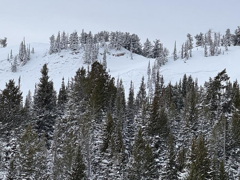
Recent avalanches were reported from the Ant Knolls zone, including the Ant Knolls ridgeline, Ant Eater, Ant Hill, and other steep E-NE-E slopes above 9,000'. These avalanches likely occurred on the old faceted snow, with some possibly triggered by wind loading. This is an example of the type of avalanche we could see today.
Avalanche Problem #2
Wind Drifted Snow
Type
Location
Likelihood
Size
Description
Northwesterly winds have been cranking the past few days, with gusts over 100 mph. These strong winds have formed soft and hard slabs of wind-drifted snow on upper and mid-elevation slopes and even some lower-elevation terrain. Such strong winds mean any aspect could be loaded.
These smooth, rounded pillows of wind-drifted snow rest on a variety of very weak layers. Alone, they could catch and carry a rider, but combined with the buried weak layers, they could trigger large avalanches—breaking 1-8 feet deep and up to 2,000 feet wide.
Best Bet: Stick to sheltered, lower-angle terrain out of the wind.
Outside the Wind Zone: Sensitive soft slabs of new snow may still linger on all aspects and elevations, with the potential to step down into deeper weak layers.
Additional Information
It's not all doom and gloom. This weak layer will settle out eventually and, in the meantime, you can travel on slopes less than 30° in steepness, check out some of our free online learning, or work on your rescue skills in lower angle meadows.
General Announcements
This information does not apply to developed ski areas or highways where avalanche control is normally done. This forecast is from the U.S.D.A. Forest Service, which is solely responsible for its content. This forecast describes general avalanche conditions and local variations always occur.