Forecast for the Provo Area Mountains

Dave Kelly
Issued by Dave Kelly on
Monday morning, December 19, 2022
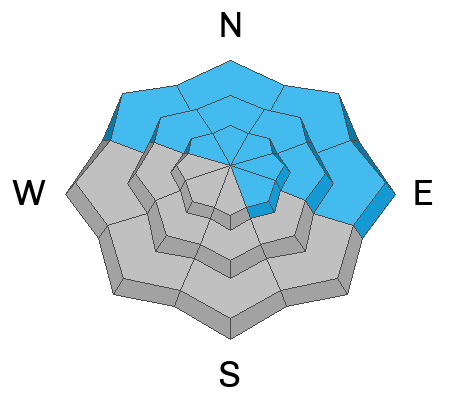
There is an overall MODERATE avalanche danger at all elevations northwest-north-northeast-east because of a persistent weak layer buried 1-4' deep. There is also a MODERATE danger on all aspects at upper elevations because increased winds have been drifting snow.

There is a LOW danger at low and mid elevation slopes facing west and southerly directions.

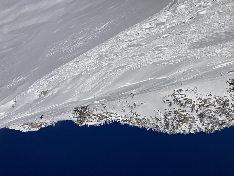
The likelihood of triggering an avalanche is going down, but the consequences remain HIGH. Step out thoughtfully and choose terrain that won't ruin your season if you're wrong.

Read about decision making making during MODERATE hazard HERE.
Low
Moderate
Considerable
High
Extreme
Learn how to read the forecast here
Special Announcements
Please join Utah Avalanche Center forecaster Craig Gordon as he takes a deep dive and reflects on recent close calls along with what’s going on with our current snowpack structure and what's in the store for the future.
Thursday December 22, 2022 -Alpha Coffee -7260 Raquet Club Dr, Cottonwood Heights, UT 84121
Weather and Snow
Skies are clear. Mountain temperatures are in the teens F to low 20's F. Winds are southwesterly, blowing 20 MPH with gusts into the 30's MPH.
For today, we'll have sunny skies with moderate to strong westerly winds. Temperatures will warm to the mid to high-20s.

Snow Depths range from 20-35" in the lower elevation terrain.
Recent Avalanches

THERE WERE THREE SIGNIFICANT AVALANCHE ACCIDENTS LAST WEEK (Loafer Canyon, Pink Pine, and Thomas Fork) with serious injuries. Two injured parties required rescues. Read a general summary "Dangerous and Unusual Avalanche Conditions".
Ad
Avalanche Problem #1
Persistent Weak Layer
Type
Location
Likelihood
Size
Description
There is weak, sugary faceted snow (a persistent weak layer, or PWL) on almost all aspects and elevations throughout the Wasatch Range. This PWL has been buried by several feet of storm snow and wind-drifted snow which has created dangerous avalanche conditions. This persistent weak layer is still dangerous on aspects facing northwest through north and east where triggering avalanches is less likely than it was yesterday. I would be stepping out into MODERATE terrain with optimistic caution and making sure I had all my bases covered, avoid stepping out in really high consequence terrain, have a partner and a plan in case the slope I was skiing on avalanched.
Spatial variability is key to avalanches and stability right now. What this means is that different elevations and aspects have differing snowpack structure, stability, and energy. I would want to know exactly how deep this persistent weak layer is before jumping into steep northerly facing terrain. The structure (overall layering of the snow) is still poor with weak fist hard facets under the new snow although test results are showing that this is healing in some places.
Just because things are solid in one location does not translate to other locations even a few miles away.

Although avalanches involving this PWL are less likely on solar aspects facing west through south, there is uncertainty with wind loading and avalanches failing in this PWL are still possible.
Avalanche Problem #2
Wind Drifted Snow
Type
Location
Likelihood
Size
Description
Westerly winds overnight have had plenty of low-density snow to blow around and you are likely to find sensitive slabs of wind-drifted snow at the upper elevations. The new soft slabs will be most pronounced on south through east facing slopes.
Any wind slab avalanche that you trigger has the potential to step down into deeper weak layers in the snowpack, creating a very large and dangerous avalanche.
On Saturday December 17 there was a skier triggered avalanche on the south face of Lone Peak. This slide was 150' wide and 8"-12" deep. I would expect to see similar wind drifted avalanches in isolated areas.
Photo (G. Gavin)
Additional Information
General Announcements
As the end of the year approaches, please consider a donation to the UAC to support avalanche forecasting.

This information does not apply to developed ski areas or highways where avalanche control is normally done. This forecast is from the U.S.D.A. Forest Service, which is solely responsible for its content. This forecast describes general avalanche conditions and local variations always occur.