Forecast for the Provo Area Mountains

Dave Kelly
Issued by Dave Kelly on
Tuesday morning, December 20, 2022
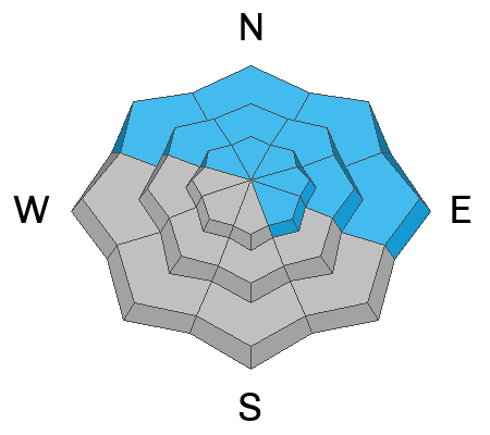
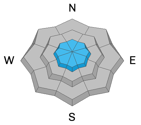
The avalanche danger is MODERATE at all elevations northwest-north-northeast-east because of a persistent weak layer buried 1-4' deep. There is also a MODERATE danger on all aspects at upper elevations because increased winds have been drifting snow.

There is a LOW danger at low and mid elevation slopes facing west and southerly directions.
Low
Moderate
Considerable
High
Extreme
Learn how to read the forecast here
Special Announcements
Please join Utah Avalanche Center forecaster Craig Gordon as he takes a deep dive and reflects on recent close calls along with what’s going on with our current snowpack structure and what's in the store for the future.
Thursday December 22, 2022 -6:00 PM-Alpha Coffee -7260 Racquet Club Dr, Cottonwood Heights, UT 84121
Weather and Snow
There was no new snow overnight. Temperatures are in the mid 20's F. Winds are southwesterly in the mid teens MPH gusting to the mid 20's MPH at the 9000' ridgelines.
Today, increasing high clouds with a trace of snow expected. Temperatures will be 24-28 F. Winds at the 9000' ridgelines will blow from the southwest 20 gusting to 25 and at the 11,000' ridgelines west-southwest 35 gusting to 50 MPH.

The National Weather Service has issued a Winter Weather Advisory from midnight tonight to Thursday at 4:00 AM with 6-12" of snow expected. This will be followed up by another storm on Friday.
Recent Avalanches
There have been no reported avalanches from backcountry skiers and riders since Sunday. Observers continue to report poor snowpack structure in the lower elevations areas.

UAC forecasters got out to the Provo area mountains yesterday. Read about their observations HERE, and HERE.
Ad
Avalanche Problem #1
Persistent Weak Layer
Type
Location
Likelihood
Size
Description
There is weak, sugary faceted snow (a persistent weak layer, or PWL) buried 1-4' deep on almost all aspects and elevations throughout the Wasatch Range. Avalanches on this layer are most likely on slopes facing northwest-north-east- southeast especially ones with the additional weight of wind drifted snow.

Avalanches are unlikely on solar aspects west through south where there haven't been any reported avalanches on this layer. The easiest way to avoid any avalanche is go on slopes less than 30 degrees with nothing steeper above. Read about slope selection HERE.
Avalanche Problem #2
Wind Drifted Snow
Type
Location
Likelihood
Size
Description
Increased westerly winds have wreaked havoc with the upper elevation snow surface. You are likely to find sensitive slabs of wind-drifted snow at the upper elevations. The new soft slabs will be most pronounced on south through east facing slopes. Even with the recent wind damage there were reports of excellent skiing and riding to be had on all aspects.

Any wind slab avalanche that you trigger has the potential to step down into deeper weak layers in the snowpack, creating a very large and dangerous avalanche.
Additional Information
Read about decision making during MODERATE hazard HERE.
General Announcements
As the end of the year approaches, please consider a donation to the UAC to support avalanche forecasting.

This information does not apply to developed ski areas or highways where avalanche control is normally done. This forecast is from the U.S.D.A. Forest Service, which is solely responsible for its content. This forecast describes general avalanche conditions and local variations always occur.