Join us at our 2nd Annual Blizzard Ball

Forecast for the Provo Area Mountains

Trent Meisenheimer
Issued by Trent Meisenheimer on
Saturday morning, December 16, 2023
The avalanche danger is LOW, and triggering an avalanche is unlikely. Watch for unstable snow on isolated terrain features.

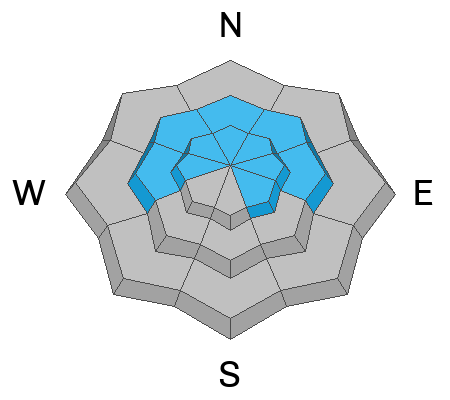
You must continually evaluate the stability of the snowpack when traveling in steep terrain on slopes facing west, north, and east where a persistent weak layer buried 2-4' deep exists.
Low
Moderate
Considerable
High
Extreme
Learn how to read the forecast here
Special Announcements
The Wasatch Backcountry Alliance has released a Public Notice regarding access to Grizzly Gulch in upper Little Cottonwood Canyon. Please give it a quick read HERE.
Weather and Snow
Aspen Grove weather station, at an elevation of 6,880' reports a mountain temperature of 21 °F this morning. Arrowhead weather station sits 1,400' above Aspen Grove and records a mountain temperature of 40°F. That's a 19-degree difference in temperature and has to be one of the stronger temperature inversions I've seen in a while and shows the high pressure (no weather) pattern we are in.
Today, we will see plenty of sunshine and temperatures climbing into the upper 30s and low 40s °F. Winds will remain from the southwest and blow 5-15 mph. Our extended forecast calls for the possibility of a few inches of snow late Monday into Tuesday (fingers crossed). Looking further out, it's not good.
The Diurnal cycle (day to night) is taking it's toll on our snow surface. Temperature changes and the energy balance of incoming shortwave radiation and longwave outward radiation are causing our adolescent snowpack to deteriorate, becoming weaker and weaker and more faceted every day. The good news is the riding and turning conditions are pretty good. The bad news is we are developing a nasty weak layer that will haunt us in the future.
Recent Avalanches
Explosive work in representable backcountry terrain produced no results yesterday. In the backcountry, no new avalanches were reported.
Ad
Avalanche Problem #1
Persistent Weak Layer
Type
Location
Likelihood
Size
Description
The buried persistent weak layer (PWL) is becoming dormant, and triggering an avalanche that fails on this layer is unlikely. However, the mountains are wild and dangerous in general, and you could still trigger an avalanche in isolated terrain - especially where there is a thinner snowpack. If you do start an avalanche, it could be 2-4' deep and over a hundred feet wide.
If you are getting into big terrain where this PWL exists, you must continually evaluate the snowpack looking for the dangerous structure of strong snow over weak snow. AND remember, the consequence of an avalanche can change dramatically depending on the terrain you're in.
Video: Forecaster Dave Kelly explaining our snowpack.
General Announcements
This information does not apply to developed ski areas or highways where avalanche control is normally done. This forecast is from the U.S.D.A. Forest Service, which is solely responsible for its content. This forecast describes general avalanche conditions and local variations always occur.