Forecast for the Provo Area Mountains

Trent Meisenheimer
Issued by Trent Meisenheimer for
Sunday, December 17, 2023
The avalanche danger is LOW, and triggering an avalanche is unlikely. Watch for unstable snow on isolated terrain features.

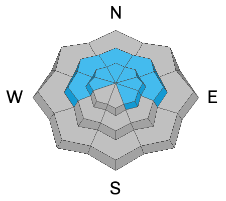
You must continually evaluate the stability of the snowpack when traveling in steep terrain on slopes facing west, north, and east where a persistent weak layer buried 2-4' deep exists.
Low
Moderate
Considerable
High
Extreme
Learn how to read the forecast here
Special Announcements
The Wasatch Backcountry Alliance has released a Public Notice regarding access to Grizzly Gulch in upper Little Cottonwood Canyon. Please give it a quick read HERE.
Weather and Snow
Yesterday afternoon, winds veered from the southwest, worked their way clockwise, and now blow from the northwest. This morning, wind speeds picked up a bit and now blow 10-15 mph, gusting into the 20s across most ridgelines. Higher up at 11,000', the winds blow from the northwest at 20-30 mph. Under clear skies, mountain temperatures range from 19 °F in the valley bottoms and 33°F at Mid Mountain (7,500')
Another day of high pressure is on tap with plenty of sunshine and the occasional passing cloud. The temperature will climb into low to mid 40 °F. Winds will remain from the northwest at similar speeds as above. Fingers crossed that we get a couple of inches of snow this coming week. Our weather looks bleak until maybe after Christmas.
The Diurnal cycle (day to night) is taking it's toll on our snow surface. Temperature changes and the energy balance of incoming shortwave radiation and longwave outward radiation are causing our adolescent snowpack to deteriorate, becoming weaker and weaker and more faceted every day. The good news is the riding and turning conditions are pretty good. The bad news is we are developing a nasty weak layer that will haunt us in the future.
Recent Avalanches
None.
Ad
Avalanche Problem #1
Persistent Weak Layer
Type
Location
Likelihood
Size
Description
The buried persistent weak layer (PWL) is becoming dormant, and triggering an avalanche that fails on this layer is unlikely. However, the mountains are wild and dangerous in general, and you could still trigger an avalanche in isolated terrain - especially where there is a thinner snowpack. If you do start an avalanche, it could be 2-4' deep and over a hundred feet wide.
If you are getting into big terrain where this PWL exists, you must continually evaluate the snowpack looking for the dangerous structure of strong snow over weak snow. AND remember, the consequence of an avalanche can change dramatically depending on the terrain you're in.
Video: Forecaster Dave Kelly explaining our snowpack.
General Announcements
This information does not apply to developed ski areas or highways where avalanche control is normally done. This forecast is from the U.S.D.A. Forest Service, which is solely responsible for its content. This forecast describes general avalanche conditions and local variations always occur.