Forecast for the Provo Area Mountains

Greg Gagne
Issued by Greg Gagne for
Friday, November 30, 2018
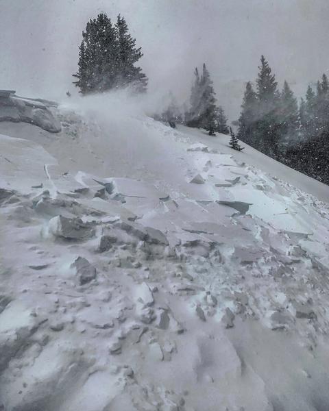
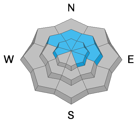
Human triggered avalanches are very likely on slopes facing northwest through east at upper elevations where the avalanche danger is HIGH. At the mid elevations the hazard is CONSIDERABLE on these aspects, as well as at upper elevations on aspects facing west through southeast.
Travel is not recommended on or adjacent to slopes steeper than 30 degrees at the mid and upper elevations on aspects facing northwest through east.
The good news is that the 12-18" of dense snow that has fallen since Wednesday has helped fill in mid and upper elevation southerly aspects, providing safer riding opportunities as well as excellent riding on lower-angled slopes.
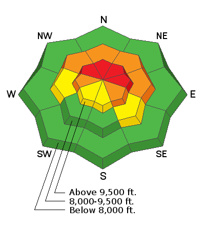
Low
Moderate
Considerable
High
Extreme
Learn how to read the forecast here
Special Announcements
We have a couple of fun events coming up on December 5th and 6th in Salt Lake and Park City. Topics include Recreating in New Zones, Women's Specific Avalanche Awareness, and a slide show from Ascent Magazine. More info about these events HERE.
The UAC IOS App is not compatible with the new UAC website. We are working to release an updated version of the app as soon as possible. Please bear with us as we get the new app completed and released.
Weather and Snow
Overnight snow totals in the Provo mountains include 9" with 1.2" of water. Since Wednesday, storm totals are 18" with 2" of water.
Although southerly winds were strong on Thursday along the ridgelines, they have diminished somewhat and are now westerly and light at the low elevations, gusting into the teens at mid elevations, and 20's mph at the upper elevations.
Mountain temperatures range throughout the 20's F.
The snowpack is slowly growing and ranges from 18-42". The recent storm snow has been dense, creating very supportable conditions for travel and riding on low-angled terrain.
For today expect cloudy skies and mountain temperatures in the 20's F. Winds will be westerly and generally light, although gusting into the teens and low 20’s along the ridge lines. We are expecting a break in the snow this morning, with snowfall expected to pick up in the afternoon, possibly becoming heavy by around sunset. An additional 3-6" of snow is forecasted overnight as winds shift to the northwest, with temperatures turning colder. A break in snowfall on Saturday morning, with more snow expected Saturday night. With cold temperatures forecasted for the weekend, any snowfall should be classic Wasatch fluff.
Recent Avalanches
No avalanche activity reported from the Provo mountains. The only backcountry avalanche activity reported from the Salt Lake mountains on Thursday were some sensitive wind drifts along upper elevation lee ridgelines from the southerly winds (Mark White photo)
Ad
Avalanche Problem #1
Persistent Weak Layer
Type
Location
Likelihood
Size
Description
I am feeling very uneasy about our persistent slab problem. The loud, booming collapses since last weekend are fewer, but the slab on top of the October facets has grown denser and deeper, now burying the October facets 18-36" down. In the past two days we have added about 1.5" of water weight as well as dense wind drifts from Thursday's southerly winds, creating the possibility for very large and destructive avalanches on northerly aspects.
It doesn't really matter how we color the rose or the term we use to describe the overall hazard, simply do not travel on or adjacent to slopes steeper than 30 degrees on aspects facing northwest through east at the mid and upper elevations. Human-triggered avalanches are very likely, including triggering large avalanches remotely (from a distance.) Existing tracks are no indication of stability, but rather, of a rider who just got away with it.
Avalanche Problem #2
Normal Caution
Type
Location
Likelihood
Size
Description
Recent storm snow and fresh wind drifts may create small localized loose sluffs and/or small storm/wind slabs at the upper elevations, particularly if winds blow stronger than forecasted or snowfall rates increase. Ski cuts are very effective at mitigating this hazard.
General Announcements
This information does not apply to developed ski areas or highways where avalanche control is normally done. This advisory is from the U.S.D.A. Forest Service, which is solely responsible for its content. This advisory describes general avalanche conditions and local variations always occur.