Forecast for the Provo Area Mountains

Trent Meisenheimer
Issued by Trent Meisenheimer for
Friday, November 24, 2023
Update for Friday, November 24 at 7:10 AM
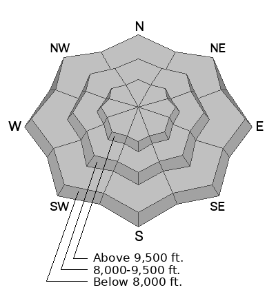
Today, we can expect dry-loose avalanches and small new snow soft slab avalanches across all aspects and elevations. On mid and upper-elevation northerly-facing slopes, it will be possible for a human to trigger an avalanche 1-3' deep that fails deeper in the snowpack on fragile faceted snow.
Evaluate the snow and terrain carefully; identify features of concern. Natural avalanches will be unlikely; human-triggered avalanches will be possible.
Low
Moderate
Considerable
High
Extreme
Learn how to read the forecast here
Special Announcements
Check uphill travel policies at resorts before you head up to their terrain.
Weather and Snow
It’s snowing, and mountain temperatures resemble what winter should feel like. This morning and overnight, the winds have been well-behaved and generally from the southerly direction, with speeds of 5-10 mph gusting to 15 mph across the uppermost elevations. However, this morning the winds at one station have picked up and are blowing northeast at 15-20 mph gusting 25 mph. Current mountain temperatures range from 15-21 °F.
Overnight, the mountains picked up roughly 4-8 inches of new snow containing 0.30-0.64 inches of water across the range. This low-density snow is what dreams are made of. Blower Pow!
Our current storm is a closed low-pressure system spinning counterclockwise around the City of Salt with the eye of the storm in Wendover. This means we should see light winds from the southerly direction for most of the day, with periodic snowfall that could be heavy at times (bands of snow) that could add another few inches to the storm totals. Mountain temperature will climb into the mid to low 20s °F before dropping into the teens °F overnight.
Recent Avalanches
No recent avalanche activity has been reported. Click here to submit an observation.
Ad
Avalanche Problem #1
New Snow
Type
Location
Likelihood
Size
Description
As the new snow falls straight out of the sky, the in-your-face problem will likely be dry-loose avalanches from the low-density snowfall. However, it may also be possible to trigger shallow soft slabs up to a foot deep. Depending on your terrain selection, I expect these avalanches to be small and not much of a problem.
Avalanche Problem #2
Persistent Weak Layer
Type
Location
Likelihood
Size
Description
Across the mid and upper-elevation northerly facing terrain, you will find weaker faceted snow buried in the snowpack. These fragile surgery gains are now buried 1-3’ deep in many locations, and it is possible to trigger an avalanche today that breaks deeper into the snowpack ,making a much more dangerous avalanche.
Terrain that faces the north half of the compass and on slopes that look smooth and covered are the exact slopes I would avoid for now. The bad news: These are the slopes that will look the best to ride and, unfortunately, will be the most dangerous. The other bad news is the aspects that don’t hold faceted snow (southerly facing terrain) were mostly bare before this storm and, therefore, will be hardly worth riding.
The best and safest option for riding and turning will be north-facing terrain that isn’t steep enough to avalanche (slopes less than 30° degrees in steepness).
Video: Snowpit observation on a north-facing slope at 9,600’ in elevation.