Holiday Auction is Live!

Forecast for the Provo Area Mountains

Drew Hardesty
Issued by Drew Hardesty on
Thursday morning, November 19, 2026

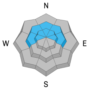
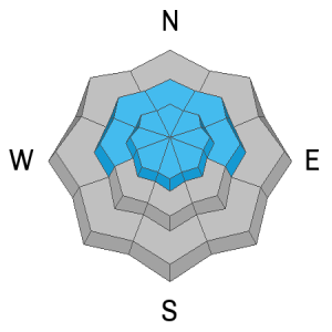
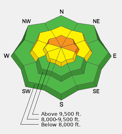
Most terrain has either LOW or MODERATE avalanche danger. Areas of CONSIDERABLE avalanche danger, however, do exist in steep upper elevation terrain. This danger is most pronounced on northwest to east facing slopes that hold the most recent wind drifting AND harbor the weakest and most prevalent persistent weak layers (PWLs) from early season. Avoidance is key. You may also trigger pockety slabs of wind drifted snow 10-20" thick on many slopes around the compass at the mid and upper elevations.
Low
Moderate
Considerable
High
Extreme
Learn how to read the forecast here
Special Announcements

***We will continue to issue danger ratings as conditions warrant.***

SAVE THE DATE!

Weather and Snow

Skies are overcast ahead of the next storm. Temperatures are in the upper 20s; winds are moderate to strong out of the south. We should see light snowfall throughout the day with 2-4" possible by dinner. This large and complex storm lasts through Saturday and we could see 8-12" in the mountains. The long term forecast looks fairly active and stormy through Thanksgiving.

Skiing and riding conditions are really limited to just the upper elevations, but that's where most of the avalanche danger exists. There's just about a foot of snow on the ground at 8000' but up to 3' up high. I was in the northern part of the southern Wasatch near Box Elder on Sunday and found lots of weak sugary faceted snow - a poor foundation for all these recents storm. I did not note any avalanches then, but avalanche conditions spiked with Tuesday night's storm. More below.

Recent Avalanches

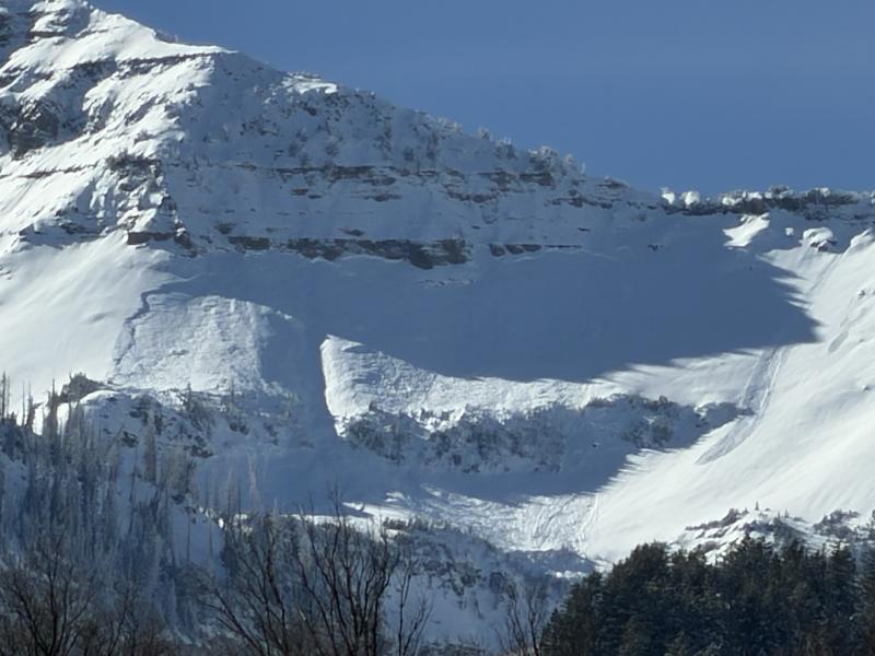
Perhaps the most impressive natural was found down along the Cascade Ridgeline on a steep northeast facing slope at 10,600'. This avalanche occurred very early yesterday morning at the end of the storm.

Upper Bunnels in the south fork, photo UDOT Provo Canyon forecaster John Woodruff

--------

You can find all recent observations HERE.

Avalanche Problem #1
Persistent Weak Layer
Type
Location
Likelihood
Size
Description

We have a conditionally unstable snowpack where the recent storm snow and wind drifted snow sits uneasily over a few inches of weak sugary faceted snow from late October/early November. In simple terms, we have strong snow over weak snow and it only takes a moment to pull out your shovel to see the chalky white storm snow over the grey and granular loose faceted grains of sugar.

The early season weak snow exists - conservatively - on westerly to northerly to easterly facing slopes above about 9000'. I will be avoiding these slopes - especially recently wind drifted slopes - for now.

Avalanche Problem #2
Wind Drifted Snow
Type
Location
Likelihood
Size
Description

Most of the recent wind drifts are the result of loading from the moderate to strong southerly winds yesterday and will be found on the north side of the compass. Lest we forget, strong west to northwest winds occurred just after frontal passage only 24 hours ago so don't be surprised to see pockets and drifts around the compass. Of note, some of these slabs of wind drifted snow are now stiff and stubborn and may crack out after you're well out onto the slab. More info on wind slabs HERE.

Additional Information

Forecaster's Corner: In truth, the bottom line danger rating hovers somewhere between upper end MODERATE and lower end CONSIDERABLE. Early season conditions are often tricky because of so much spatial variability and so much uncertainty. Even today, there will probably be less "obvious signs of instability" such as audible collapsing and shooting cracks. Where the rubber hits the road, though, is how I might approach terrain with trip planning at the coffee table. Based on the size and distribution of the natural and explosive triggered slides from Tuesday night and Wednesday (and frankly because the Cascade Ridgeline avalanche above looks terrifying), I would rule out steep upper elevation polar terrain and instead choose low angle slopes.

General Announcements

This information does not apply to developed ski areas or highways where avalanche control is normally done. This forecast is from the U.S.D.A. Forest Service, which is solely responsible for its content. This forecast describes general avalanche conditions and local variations always occur.

Observations and Avalanches

Backcountry Emergency Procedures

SMS Notifications

Instagram

Facebook

Get Forecast Email

Previous Forecasts

Contact via email

Submit Observation