Forecast for the Provo Area Mountains

Drew Hardesty
Issued by Drew Hardesty for
Tuesday, January 9, 2024
We have a CONSIDERABLE avalanche danger in the backcountry. Natural avalanches are possible and human triggered avalanches are likely. The danger is most pronounced on recently wind drifted slopes. Know that avalanches may be triggered remotely (at a distance) or from below. Collapsing and cracking is to be expected. Most accidents and fatalities occur with a CONSIDERABLE danger. Conditions will be changing rapidly today.
Low
Moderate
Considerable
High
Extreme
Learn how to read the forecast here
Avalanche Watch
THE FOREST SERVICE UTAH AVALANCHE CENTER IN SALT LAKE CITY HAS ISSUED A BACKCOUNTRY AVALANCHE WATCH WHICH IS IN EFFECT FROM 6AM MST TUESDAY TO 6AM MST FRIDAY.
* WHAT...THE AVALANCHE DANGER IS EXPECTED TO REACH HIGH.
* WHERE...FOR THE MOUNTAINS OF NORTHERN AND CENTRAL UTAH AND SOUTHEAST IDAHO, TO INCLUDE THE WASATCH RANGE...THE BEAR RIVER RANGE..UINTA MOUNTAINS...AND THE MANTI-SKYLINE PLATEAU.
* WHEN...IN EFFECT FROM 6AM MST TUESDAY TO 6AM MST FRIDAY.
* IMPACTS...EXPECTED STRONG WIND AND HEAVY SNOWFALL WILL CREATE WIDESPREAD AREAS OF DANGEROUS AVALANCHE CONDITIONS. BOTH HUMAN TRIGGERED AND NATURAL AVALANCHES ARE LIKELY.
* PRECAUTIONARY/PREPAREDNESS ACTIONS...STAY OFF OF AND OUT FROM UNDERNEATH SLOPES STEEPER THAN 30 DEGREES.
Special Announcements
There was a very close call in the Hells Canyon backcountry area outside of the Snowbasin Ski Area boundary yesterday.
If you trigger an avalanche in the backcountry, but no one is hurt and you do not need assistance, please notify the nearest ski area dispatch to avoid a needless response by rescue teams. Thanks.
Salt Lake Cottonwood Canyons – Alta Central (801-742-2033)
Park City Ridgeline - Park City Mountain Dispatch (435-615-1911)
Ogden - Snowbasin Resort Dispatch (801-620-1017), Powder Mountain Dispatch (801-745-3772 x 123)
Provo - Sundance Dispatch (801-223-4150)
Weather and Snow
Skies are overcast in this warm sector portion of the first storm. Mountain temperatures are in the single digits to low teens but on a warming trend. Winds are playing the spoiler, blowing 15-20mph with gusts to 30, but along the higher ridgelines, they are averaging 40-50mph with gusts to 65. They are just getting started.
For today, we'll have light snowfall, temps warming to the upper teens to low 20s, and STRONG winds from the west-southwest. A vigorous cold front arrives around dinner time that'll drive high snowfall rates and blowing and drifting snow. Snowfall continues overnight and we should see 4-8" by tomorrow morning. Another cold front arrives Wednesday afternoon with more snow through the week. A more powerful storm arrives over the weekend.

HEADS UP - We are on the cusp of a long and sustained period of snow and strong wind. These will be very real and very dangerous avalanche conditions.
Recent Avalanches
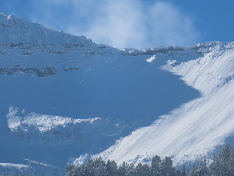
With some clearing, UDOT Provo was able to gauge the extent of some significant avalanche activity along the Cascade ridgeline from Sunday. Most of these were in the mid and upper elevations and generally east facing, but not limited to this. Photo below; full observation HERE.
Ad
Avalanche Problem #1
Wind Drifted Snow
Type
Location
Likelihood
Size
Description
Increasing winds from the west will easily whip the new snow into soft slabs that will be sensitive to provocation. These soft slabs will be most pronounced on north to east to south facing slopes at the mid and upper elevaions. Know that winds at these speeds tend to deposit snow into unusual loading patterns (see usual pattern graphic below) so don't get caught off guard by finding soft slabs well down off the ridgelines or around terrain features or cross-loaded into gullies and couloirs.
Drifting and loading will be extensive enough for some NATURAL AVALANCHES to occur in steep terrain.
Avalanche Problem #2
Persistent Weak Layer
Type
Location
Likelihood
Size
Description
The December drought layer PWL of weak sugary facets is now capped by 6-18" of low density snow...And now further stressed and overloaded by blowing and drifting snow. Cracking and collapsing will be much more common today, as will both natural and human triggered avalanches.
WHAT IS UNUSUAL is that we have a weak PWL (persistent weak layer) that exists on more aspects than usual (see locator rose)
WHAT IS TRICKY is what is almost always tricky with recently buried and stressed PWLs - you can trigger them from a distance or below.
General Announcements
This information does not apply to developed ski areas or highways where avalanche control is normally done. This forecast is from the U.S.D.A. Forest Service, which is solely responsible for its content. This forecast describes general avalanche conditions and local variations always occur.