Forecast for the Provo Area Mountains

Dave Kelly
Issued by Dave Kelly for
Wednesday, January 10, 2024
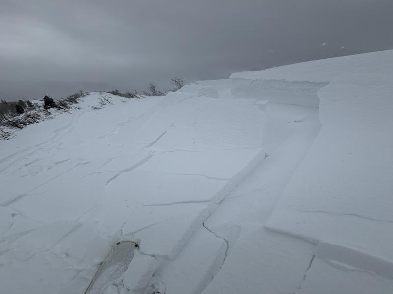
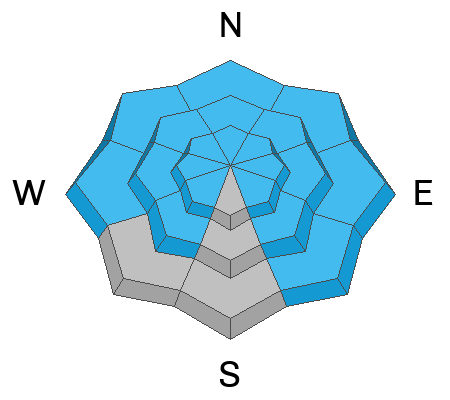
The avalanche danger is HIGH at mid and high elevations due to recent heavy snowfall and wind-drifted snow which is sitting on top of a buried persistent weak layer (PWL). The avalanche danger is CONSIDERABLE at the lowest elevations below 8,000'. If forecasted snow comes through the lowest elevations in the Provo Area Mountains could rise to HIGH danger by later this evening
Today is a day to avoid traveling in or being underneath avalanche terrain.
Low
Moderate
Considerable
High
Extreme
Learn how to read the forecast here
Avalanche Warning
The avalanche danger for the warning area is HIGH for the mountains of northern and central Utah and southeast Idaho, which includes the Wasatch Range...the Bear River Range...Uinta Mountains...Manti-Skyline plateau...and the Mountains of Southwestern Utah.
Strong winds and heavy snowfall have created dangerous avalanche conditions. Both human triggered and natural avalanches are likely. Stay off of and out from under slopes steeper than 30°.
This avalanche warning is in Wednesday, January 10, 2024 - 6:00am to Thursday, January 11, 2024 - 6:00am
Special Announcements
Wondering what happened to the mid-pack PWL? Curious how the December dry spell will play out? Interested in what factors determine future stability trends? Please join UAC forecaster Craig Gordon at 6:00 on Thursday January 11th, at the Kimball Junction library for a FREE State of the Snowpack presentation. More INFO
Weather and Snow
Under partly cloudy skies, trailhead temperatures are in the teens °F. Winds have blown strong all night from a south-westerly direction in the mid-teens MPH gusting to the 20's with a max gust of 47 MPH at 8250'. There were reports of 2.5"-5" snow with .17"-.30" water in the last 24 hours. This snow has been heavily wind affected and deeper drifts can be found.
For today, we are expecting temperatures 20-22°f with winds blowing from the west 15 gusting to 25 MPH at the 9,000' ridgelines and 30 gusting to 45 MPH at the 11,000' ridgelines. Snow will continue throughout the day with 3.5-8.5" of new snow expected and up to .50" of water. There is a chance of lightning with the passing of another frontal passage late this afternoon which could bring increased snowfall rates of up to 1.5" an hour and gusts on the ridgetops exceeding 75 MPH.

Hold onto your hats, our partners at the National Weather Service have forecasted that some areas of Northern Utah are not expected to see a break in snow until Monday which will keep the avalanche danger elevated.
Recent Avalanches
Yesterday we had a few reports of wind-drifted snow avalanches failing on facets, and over the last 24 hours there were reports of natural avalanche activity in mid Cottonwood Canyon with increased wind and snow, which is similar to what you may find in the Provo Area Mountains. Check out all avalanches HERE.
Chamberlain submitted an observation of his travels in the Tibble Fork area showing how reactive the wind-drifted snow was on an east facing slope at 7,800'.
Ad
Avalanche Problem #1
Wind Drifted Snow
Type
Location
Likelihood
Size
Description
You will find reactive soft slabs of wind-drifted snow at the mid and upper elevations. Winds at these speeds tends to deposit snow into unusual places, so don't get caught off guard when you find soft slabs well down off the ridgelines or around terrain features or cross-loaded into gullies at all aspects.
New snow drifting and loading has already been extensive enough for NATURAL AVALANCHES to have occurred in steep terrain.
Avalanche Problem #2
Persistent Weak Layer
Type
Location
Likelihood
Size
Description
The December drought layer PWL of weak sugary facets was capped by 6-18" of low-density snow...and now has been further stressed and overloaded by blowing and drifting snow. Cracking and collapsing will be much more common today, as will both natural and human triggered avalanches.
This buried PWL has been found on most aspects and elevations (see locator rose).
I will be giving this now buried PWL some time to adjust to the new snow and wind before traveling into or underneath avalanche terrain (slopes greater than 30°).
Additional Information
There was a very close call in the Hells Canyon backcountry area outside of the Snowbasin Ski Area boundary on Tuesday.
If you trigger an avalanche in the backcountry, but no one is hurt and you do not need assistance, please notify the nearest ski area dispatch to avoid a needless response by rescue teams. Thanks.
Provo - Sundance Dispatch (801-223-4150)
General Announcements
This information does not apply to developed ski areas or highways where avalanche control is normally done. This forecast is from the U.S.D.A. Forest Service, which is solely responsible for its content. This forecast describes general avalanche conditions and local variations always occur.