Forecast for the Provo Area Mountains

Trent Meisenheimer
Issued by Trent Meisenheimer for
Monday, January 28, 2019
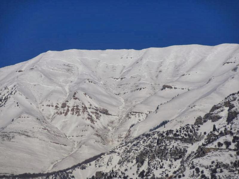
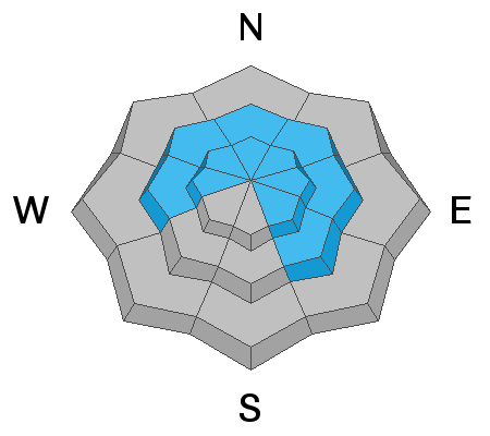
The avalanche danger is MODERATE for triggering a large, deep avalanche in isolated places at the mid & upper elevation west through southeast facing terrain. It's the classic low-probability of triggering a high-consequence avalanche. The danger is also MODERATE for triggering wind drifts at all upper elevations. For today, continue to identify and avoid any of the rounded, smooth or scalloped drifts on steep slopes.
Low
Moderate
Considerable
High
Extreme
Learn how to read the forecast here
Special Announcements
Two Utah men died in avalanches on Friday - Tommy Hawkins of Layton, Utah (snowmobiling near upper Palisades Lake, Idaho) and Scott Pehrson, of Monticello, UT (snowmobiling in the eastern La Sals, UT) We offer our deep sympathy to the family and friends of these two men.
In Utah, a huge thanks to members from San Juan and Grand County Search and Rescues, Utah Department of Public Safety, Snowbird, Wasatch Powder Bird Guides and professional avalanche rescue dogs and handlers from Wasatch Backcountry Rescue, Alta, and Park City Ski areas who conducted recovery efforts.
Weather and Snow
This morning the skies are clear, but not for long. A very weak system will cross overhead this morning ushering in some clouds, wind, and maybe a couple snowflakes. Northerly winds have increased once again and are currently blowing 20-30 mph & gusting into the upper 40's & 50's across the highest peaks. Mid elevation wind speeds are more reasonable at 10-15 mph & gusting into the 20's. By mid afternoon the trough axis passes overhead and the northerly winds should calm down. Current mountain temperatures are in the low twenties °F at the upper elevations and many of the trail heads are sitting in the mid teens °F. Clouds will begin to break up this afternoon as we return to a dry, cool, northwest flow.
Recent Avalanches
Reports of natural avalanches from the past storm cycle continue to trickle in and the list of all backcountry observations can be found HERE. Yesterday afternoon, the sun warmed the southerly facing terrain just enough and we went through a natural wet loose avalanche cycle. Many of the avalanches were small and fanned out. However, a couple traveled long distances down chutes and gullies stacking up impressive debris piles.
A very large avalanche was reported from the front side of Mount Timpanogos by UDOT forecaster John Woodruff. He was unsure on the exact timing of when this natural avalanche happened, but it's likely it happened this past week (photo below).
Ad
Avalanche Problem #1
Wind Drifted Snow
Type
Location
Likelihood
Size
Description
As the northerly winds begin to increase once again, they will find any remnants of soft snow to drift and load onto the lee terrain. The wind may also keep the old stubborn drifts just active enough to the weight of a rider. For today, continue to identify and avoid any of the rounded, smooth or scalloped drifts on steep slopes, especially in unforgiving terrain, such as above cliffs and trees.

There remains the possibility that any wind slab triggered could be enough weight on a slope to then release a much larger avalanche that breaks into weaker layers of snow, especially in terrain where the snowpack is less than about 1.5 meters deep (5 feet).
Avalanche Problem #2
Persistent Weak Layer
Type
Location
Likelihood
Size
Description
It's tough to nail down the likelyhood of triggering a large slab avalanche on our buried weak faceted snow. However, look towards the avalanches that are being triggered with explosives. Most of them have been triggered with a single hand charge and are releasing sizable avalanches easily large enough to catch, carry, bury, and kill a person. Yes, backcountry riders are riding, steep, upper elevation terrain and not triggering avalanches. Why? I don't know. It's obviously not a bad thing.
This is the time where we have the set up in the snowpack for slab avalanches (strong snow over weaker snow). However, the chances of triggering a slab avalanche remains unlikely, but if you do, it will be large and deadly. It's the classic low-probability of triggering a high-consequence avalanche. How to manage this:
1. Avoid steep (greater than 35° degree) wind loaded terrain at the upper elevations on the west through southeast facing terrain.
2. Find ways into the steeper terrain that avoids the wind loaded areas.
3. Avoid steep, shallow, rocky terrain, especially above 9,000' in elevation.
4. Ride one at a time and choose terrain where there is a clean runout.
General Announcements
This information does not apply to developed ski areas or highways where avalanche control is normally done. This forecast is from the U.S.D.A. Forest Service, which is solely responsible for its content. This forecast describes general avalanche conditions and local variations always occur.