Forecast for the Provo Area Mountains

Nikki Champion
Issued by Nikki Champion for
Thursday, January 25, 2024
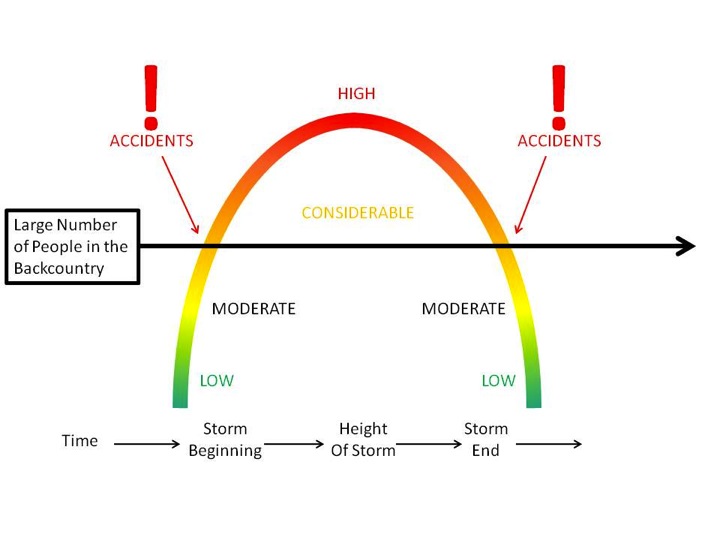
The avalanche danger is CONSIDERABLE on mid and upper elevation slopes facing west through north to southeast, and low elevation slopes facing northwest through east. Any avalanche triggered within the new snow or wind-drifted snow has the potential to step down 2-5+ feet deep into the weak faceted snow within the snowpack.
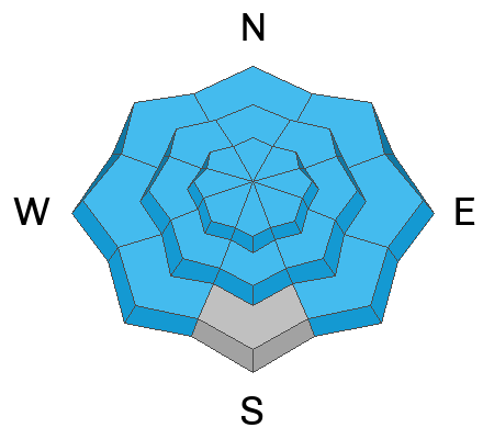
There could be a more pronounced danger where the snowpack is shallower or thinner. While it may be possible to find this layering anywhere, the terrain along the periphery is most suspect. Careful snowpack evaluation, cautious route-finding, and conservative decision-making are essential today.
Low
Moderate
Considerable
High
Extreme
Learn how to read the forecast here
Special Announcements
Join us for a Motorized Backcountry 101: Introduction to Avalanches class on February 2-3 down on the Skyline. Click here for more information and to register.
Weather and Snow
This morning, skies are overcast. Temperatures range from the upper teens to mid-20s F, accompanied by light southwesterly winds, reaching 30 mph at the highest ridgetops.
Today, a mild storm will bring widespread snowfall to the region. Temperatures will range from the low to mid-30s F, with westerly winds averaging 10-15 mph and gusting up to 35 mph along the highest ridgetops.
Initially, Provo Canyon will be favored due to southwesterly flow, resulting in higher snow density. As the flow shifts northwest, the upper Cottonwoods will experience widespread snow. Colder air will reduce snow density, and the snowfall is expected to end around midnight.
Snowfall totals should reach between 2.5-6.5" by 5 PM, with an additional 1-2" overnight. Some riming may occur late tonight into Friday morning due to lingering low-level moisture.
The Outlook: High pressure will dominate the weekend, bringing a noticeable warming trend. Mountain temperatures are expected to rise into the 40s and higher early next week, according to the models. Stay tuned for updates.
Recent Avalanches
No new avalanches were reported in the backcountry yesterday, but there were accounts of massive collapses and consistently low ECT scores. On Sunday, in the upper American Fork drainage above Forest Lake, a natural cornice fall occurred, subsequently triggering a MONSTER avalanche to the ground. The hard slab avalanche failed on a persistent weak layer of early-season depth hoar, 4-6' deep (width unknown), on a steep northeast-facing slope at 9200'. In a heavily wind-loaded part of the crown face, the depth was estimated at 15'.
At the lower elevations, wet and punchy riding conditions could exist. The new snowfall should refresh all elevations.

Be sure to check all the avalanche activity HERE.
Ad
Avalanche Problem #1
Persistent Weak Layer
Type
Location
Likelihood
Size
Description
The primary concern is triggering a large and unsurvivable hard slab avalanche on a persistent weak layer of faceted snow, which is now 2-5+ feet deep. This weak layer formed during a dry period in December and got buried on January 4th. Over time, this unstable combination has become more stubborn but remains highly dangerous, and just as deadly. Though the likelihood is slowly decreasing, the consequence remains just as high.
Beyond the highlight reel avalanches, there are less obvious yet just as significant avalanches that caught our attention last Thursday and Friday. These persistent weak layer (PWL) avalanches are away from the ridgelines, occurring within mid to low elevation bands, yet they are large enough to pose a serious threat of catching, carrying, and burying you. Continue to pay attention, as slope angle remains a crucial factor.
Thinner snowpack areas may be particularly suspect. Remember, avalanches can be triggered from a distance or below. Stay safe and be cautious.
Avalanche Problem #2
New Snow
Type
Location
Likelihood
Size
Description
The approaching front is expected to bring 4-8" of new snow. Anticipate shallow new snow avalanches in the backcountry as the snow totals increase, especially in the upper elevations, with fast-running sluffs likely.
Watch for signs of instability like cracking and sluffing, as even a small slide can pose serious risks in steep terrain or near cliffs. The sensitivity of the new snow is closely tied to the rate of snowfall, with higher rates making avalanches easier to trigger.
In the wind zone: With winds picking up and soft snow available for transport, you are likely to see soft slabs of wind-drifted snow forming on all upper-elevation slopes and mid-elevation terrain features that allow for drifting snow to accumulate today. Look for signs of wind-drifted snow, such as rounded, wavy, or pillow-shaped formations, and avoid those slopes.
Any avalanche triggered within the wind-drifted or new snow has the potential to overload or step down 2-5'+ feet deep, or even deeper, into the weak faceted snow within the snowpack, creating a very large and dangerous avalanche.
Additional Information
Forecaster's Corner: Navigating the backcountry during CONSIDERABLE avalanche danger, especially with a persistent weak layer (PWL), is challenging. The snow conditions may be excellent, and signs of instability less apparent than in HIGH or EXTREME danger. Despite our caution, we might be enticed by existing tracks and even get away with a run or two. However, this is when accidents and fatalities often occur. Over 70% of fatalities involve a persistent weak layer. If you get caught and carried today, consider where you might end up and what could happen.
General Announcements
This information does not apply to developed ski areas or highways where avalanche control is normally done. This forecast is from the U.S.D.A. Forest Service, which is solely responsible for its content. This forecast describes general avalanche conditions and local variations always occur.