Forecast for the Provo Area Mountains

Nikki Champion
Issued by Nikki Champion for
Wednesday, January 24, 2024
The avalanche danger is CONSIDERABLE on mid and upper elevation slopes facing west through north through southeast, and low elevation slopes facing northwest through east. There could be a more pronounced danger where the snowpack is shallower or thinner.
Considerable means that dangerous human-triggered avalanches are likely. Cautious route-finding and conservative decision making is essential. Essential to what? Essential to making it back to the trailhead at the end of the day. Be careful out there.
Low
Moderate
Considerable
High
Extreme
Learn how to read the forecast here
Special Announcements
Join us for a Motorized Backcountry 101: Introduction to Avalanches class on February 2-3 down on the Skyline. Click here for more information and to register.
Weather and Snow
This morning, rain is falling in the valley, and there's light snow in the mountains, with no measureable accumulation since last night. Temperatures range from the mid-20s to low 30s F, accompanied by light westerly winds, reaching 30 mph at the highest ridgetops.
Today, this weak winter system is departing, leaving a chance of lingering snow showers this morning before drying out. Temperatures will reach the mid-30s F, with light westerly winds gusting up to 30 mph along the highest ridgetops. Clouds will increase overnight into Thursday as the next Pacific Northwest system brings better snow chances later. Lighter snow showers may start around midnight, followed by more persistent snow on Thursday. Snowfall will decrease overnight into Friday, but lingering snow may occur due to orographic enhancement as the flow shifts more northwesterly. Anticipate 3-7" of new snow by Friday.
The Outlook: High pressure will dominate the weekend, bringing a noticeable warming trend. Mountain temperatures are expected to rise into the 40s and higher early next week, according to the models. Stay tuned for updates.
Recent Avalanches
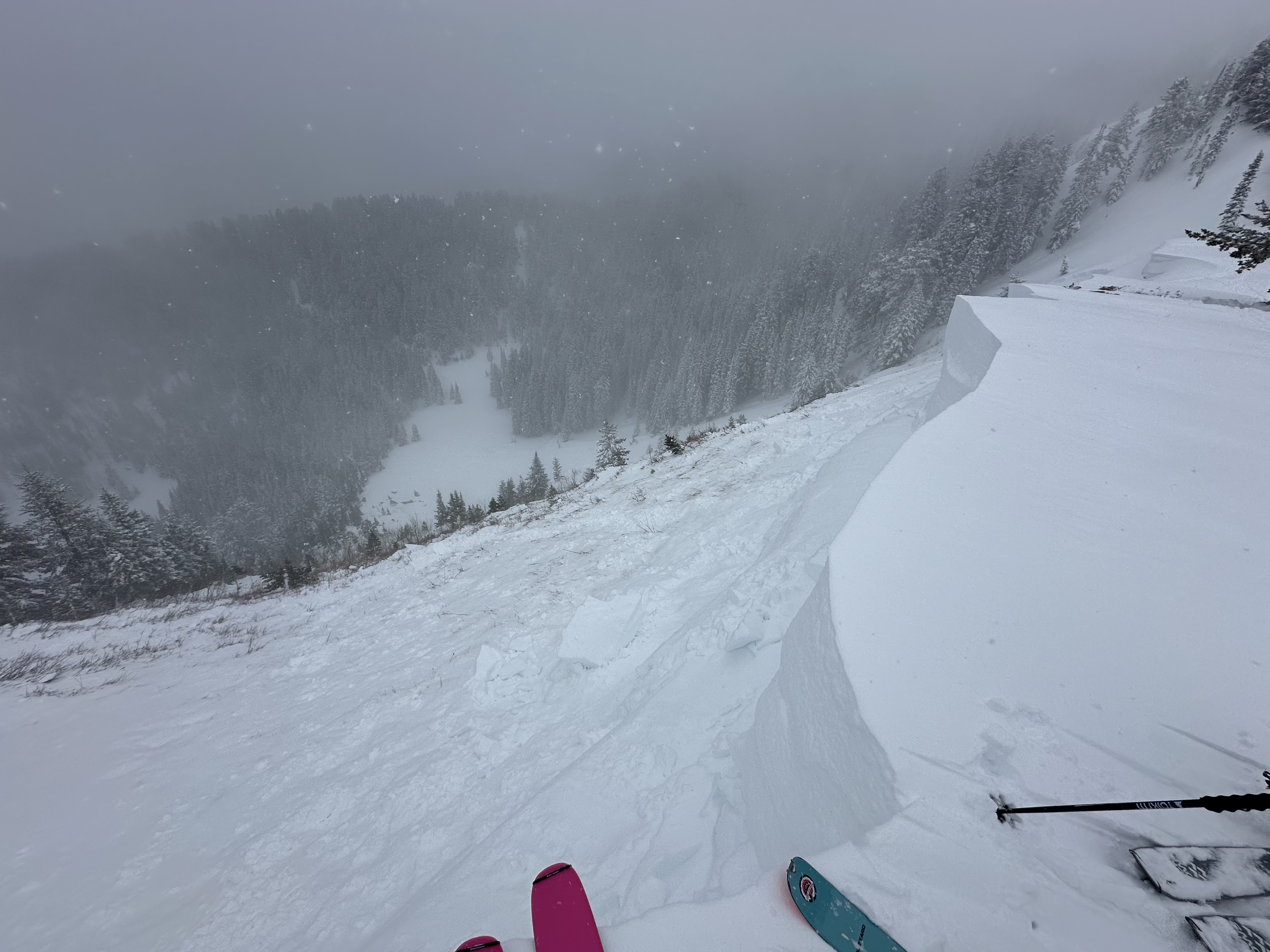
Reports of massive collapses, and low ECT scores continue to pour in. On Sunday, in the upper American Fork drainage above Forest Lake, there was a natural cornice fall which in turn triggered a 
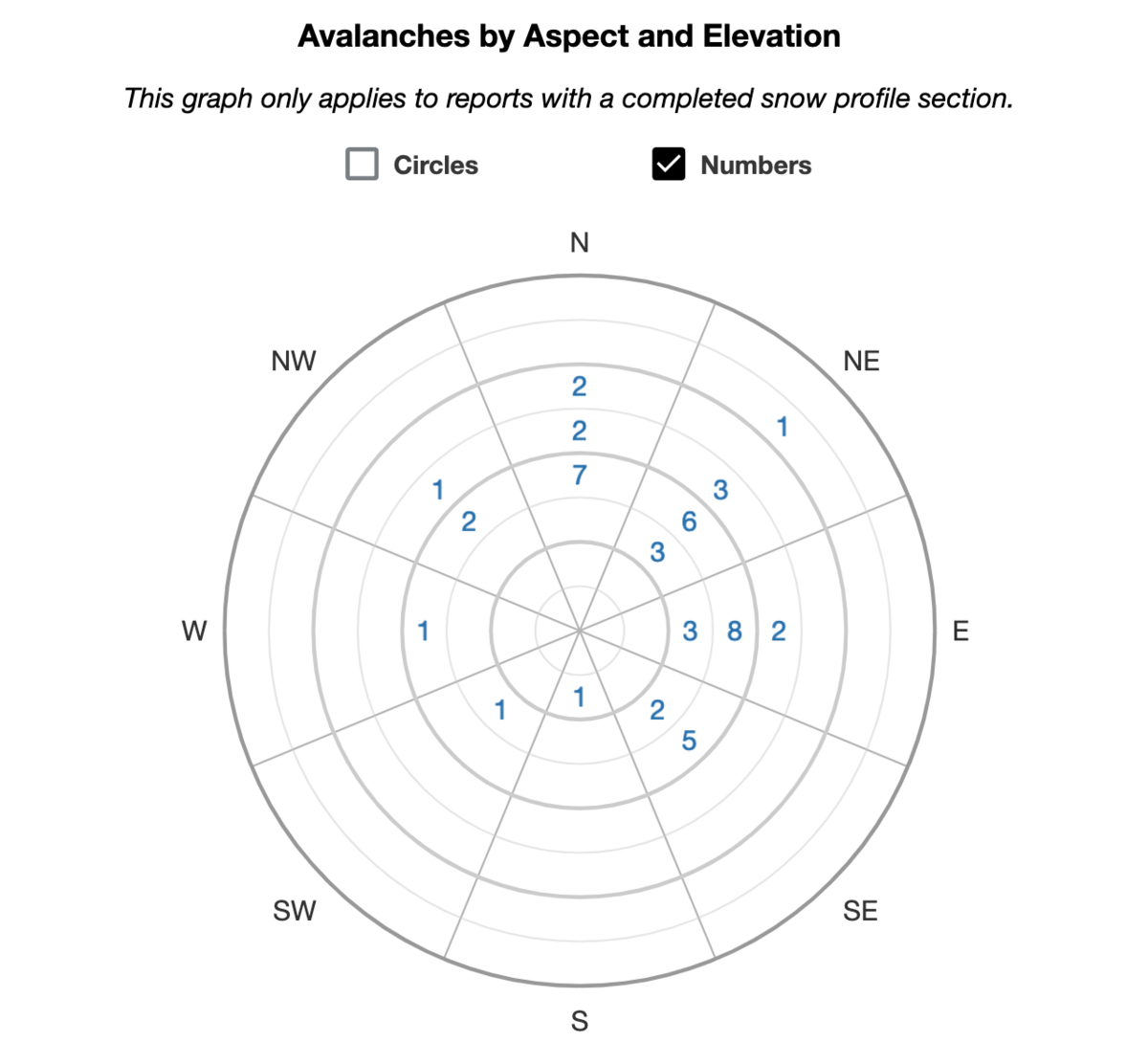
MONSTER avalanche to the ground. The hard slab avalanche failed on a persistent weak layer of early season depth hoar 4-6' deep (width unknown) on a steep northeast facing slope at 9200'. In a heavily wind loaded part of the crown-face, the depth was estimated at 15' deep. (Unsure of terrain? Check the WBSkiing map and search for Peak 9851' near Terraces, just west of Mill Canyon Peak.)
Punchy, and wet conditions may exist at lower elevations.

Be sure to check all the avalanche activity HERE.
Ad
Avalanche Problem #1
Persistent Weak Layer
Type
Location
Likelihood
Size
Description
The primary concern is triggering a large and unsurvivable hard slab avalanche on a persistent weak layer of faceted snow, which is now 2-5+ feet deep. This weak layer formed during a dry period in December and got buried on January 4th. Over time, this unstable combination has become more stubborn but remains highly dangerous, and just as deadly. Though the likelihood is slowly decreasing, the consequence remains just as high.
Beyond the highlight reel avalanches, there are less obvious yet just as significant avalanches that caught our attention last Thursday and Friday. These persistent weak layer (PWL) avalanches are away from the ridgelines, occurring within mid to low elevation bands, yet they are large enough to pose a serious threat of catching, carrying, and burying you. Continue to pay attention, as slope angle remains a crucial factor. An example from Mineral Fork on Friday, around 8800-9000', illustrates this point.
Thinner snowpack areas, especially outside the Upper Cottonwoods, may be particularly suspect. Remember, avalanches can be triggered from a distance or below. Refer to the heat map of PWL avalanches for the SLC mountains from Jan 6th below for more insights. Stay safe and be cautious.
Additional Information
Forecaster's Corner: Navigating the backcountry during CONSIDERABLE avalanche danger, especially with a persistent weak layer (PWL), is challenging. The snow conditions may be excellent, and signs of instability less apparent than in HIGH or EXTREME danger. Despite our caution, we might be enticed by existing tracks and even get away with a run or two. However, this is when accidents and fatalities often occur. Over 70% of fatalities involve a persistent weak layer. If you get caught and carried today, consider where you might end up and what could happen.
General Announcements
This information does not apply to developed ski areas or highways where avalanche control is normally done. This forecast is from the U.S.D.A. Forest Service, which is solely responsible for its content. This forecast describes general avalanche conditions and local variations always occur.