Join us for the 33rd Backcountry Benefit - Get Your Tickets Now!

Forecast for the Provo Area Mountains

Greg Gagne
Issued by Greg Gagne on
Monday morning, January 12, 2026

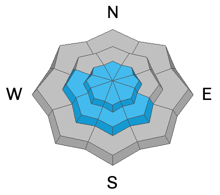
There is a MODERATE avalanche danger at the upper elevations and on sunny, mid-elevation slopes where human-triggered avalanches are possible. Avalanches may involve recent wind drifted snow at the upper elevations and sluffing in wet snow on sunny slopes and in dry snow on steep northerly slopes.

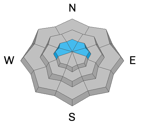
On steep, rocky, upper-elevation slopes facing west/north/east, an avalanche failing in a persistent weak layer of snow down near the ground remains possible.

Low
Moderate
Considerable
High
Extreme
Learn how to read the forecast here
Weather and Snow

This Morning: Temperatures are in the upper 20's through 30's °F and winds are from the north/northwest and light, less than 10 mph.

Today: Sunny skies with temperatures rising into the upper 30's and low 40's °F. Winds will remain light, with gusts near 20 mph at the uppermost elevations.

A sprawling ridge of high pressure dominates our weather for the next 7-10 days, with mostly sunny skies, warm temperatures, and light winds.

Solar aspects will have a sun crust, with cold, dry snow on northerly slopes.

Recent Avalanches

Other than minor, wet-loose activity on solar slopes, no avalanche activity was reported from Sunday in the Provo mountains.

Bo Torrey traveled to Forest Lake in American Fork Canyon on Sunday where he found a thin, shallow snowpack and a buried layer of surface hoar.

We continue to receive many excellent, high-quality observations.

Avalanche Problem #1
New Snow
Type
Location
Likelihood
Size
Description

(Let's call it "new-ish" snow.) There are three possible issues to watch for with our snowfall from last Thursday:

1. Wet Loose Snow: Expect minor, wet-loose avalanche activity on solar/sunny slopes as the day warms. Although these should be minor, be sure not to get caught in a steep terrain trap or carried over rocks.

2. Wind Drifts: Although most wind drifts have settled out and are now unreactive, there are some upper elevation slopes where you can find dense wind drifts that formed Friday or Saturday that may be reactive, especially on slopes with a preserved layer of surface hoar down 6-18 inches deep.

3. Sluffing: The snow surface is quickly weakening with facets and surface hoar in the top few inches of snow on shady, northerly aspects which may sluff easily on steep slopes. Just as with minor wet, loose snow, even a small sluff could carry you over rocks in steeper terrain.

Avalanche Problem #2
Persistent Weak Layer
Type
Location
Likelihood
Size
Description

Our season-long, persistent weak layer of faceted snow down near the ground is still present in our snowpack. Although we are trending toward dormancy with this problem, human-triggered avalanches remain possible in steep, rocky, upper-elevation terrain - particularly on slopes facing north and northeast. Slopes that have been recently wind-loaded are most suspect.

(Notice we have removed mid-elevations from the locator rose for this avalanche problem. The most suspect slopes are upper-elevations, but some weak snow has also been found as low as 9,300 feet.)

Additional Information

Ian McCammon and Kelly McNeil's 2024 paper Six Tips That Could Save Your Life (Recent updates to Safety Messaging) is worth a re-read. It could save your life.

General Announcements

This information does not apply to developed ski areas or highways where avalanche control is normally done. This forecast is from the U.S.D.A. Forest Service, which is solely responsible for its content. This forecast describes general avalanche conditions and local variations always occur.