Join us for the 33rd Backcountry Benefit - Get Your Tickets Now!

Observation: Forest Lake

Observation Date
1/11/2026
Observer Name
Torrey & Applegarth
Region
Provo » American Fork » Forest Lake
Location Name or Route
Shaffer Fork
Weather
Sky
Few
Wind Speed
Calm
Weather Comments
Temperatures gradually warmed through the day. Winds remained light, but evidence of old wind-drifted snow in the upper elevation exposed slopes.
Snow Characteristics
New Snow Depth
8"
New Snow Density
High
Snow Surface Conditions
Powder
Dense Loose
Damp
Snow Characteristics Comments

Soft settled powder on shady slopes, beginning to facet. W-S were damp.

Red Flags
Red Flags
Poor Snowpack Structure
Avalanche Problem #1
Problem
Persistent Weak Layer
Trend
Decreasing Danger
Problem #1 Comments

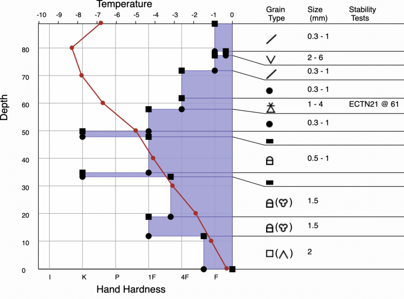
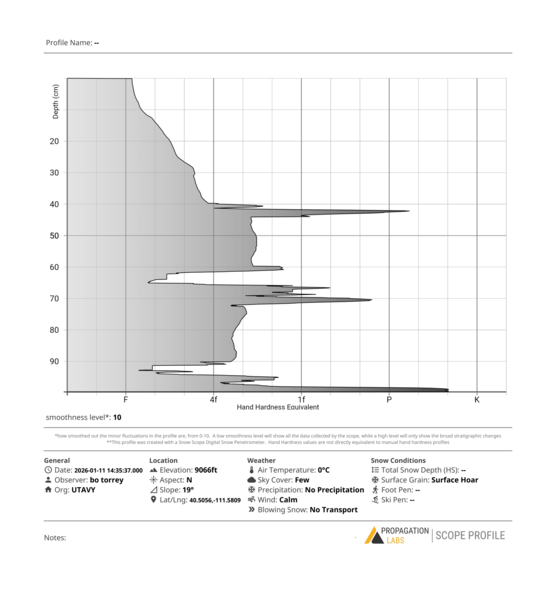
Compared to the snowpack just a few miles north near the Cottonwood Canyons, the snowpack in this area of American Fork Canyon is much shallower and weaker. The CERC is only about an inch thick here. Beneath the crust, the snow is dry, loose, and faceted. A layer of buried surface hoar was found on several shady slopes about 5 inches beneath the surface.

Avalanche Problem #2
Problem
Wet Snow
Trend
Increasing Danger
Problem #2 Comments

The gradual warming over the last two days has allowed the new snow instabilities to settle out. Roller balls and very small loose wet avalanches have occurred during the last few days. With warmer temperatures on the way, reaching above freezing at 10,000 feet, I expect more wet snow activity in the coming days.

Comments

North Aspect near Forest Lake at 9050 feet. 20˚ slope.

Today's Observed Danger Rating
Moderate
Tomorrows Estimated Danger Rating
Moderate
Coordinates