Forecast for the Ogden Area Mountains

Evelyn Lees
Issued by Evelyn Lees for
Wednesday, April 3, 2019
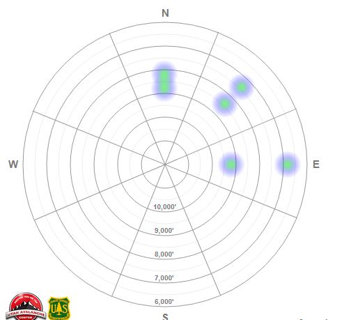
The upper elevation steep northwest through easterly facing terrain has a CONSIDERABLE danger for triggering avalanches in wind drifted snow. In isolated locations, these windslabs could trigger a deeper avalanche failing on a buried persistent weak layer.
Lower and mid elevation terrain has a MODERATE danger, where wet snow avalanches are likely.
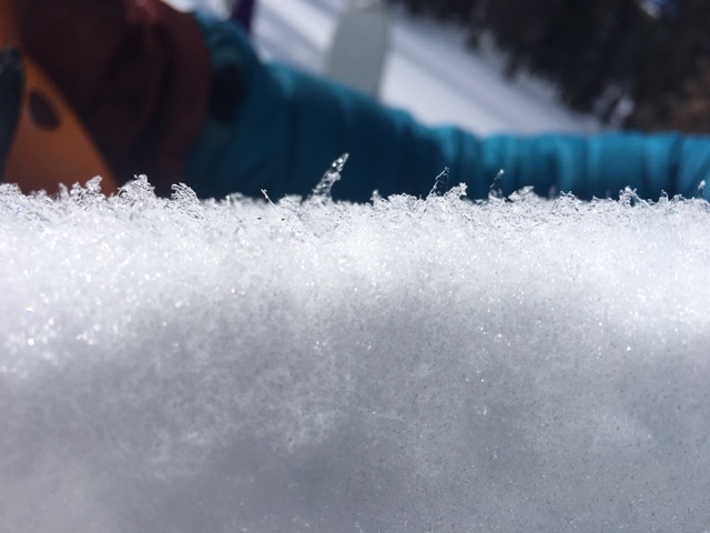
The snow will be more unstable during any periods of heavy rain or snowfall.
Low
Moderate
Considerable
High
Extreme
Learn how to read the forecast here
Special Announcements
When the forecasting ends, the UAC’s work keeps going strong. Summer is a busy time for the UAC. During the summer we are working hard on our fall and winter planning; putting together the Fall Fundraiser and the Utah Snow and Avalanche Workshop; updating our awareness and education programs; this summer we will be finishing up the website redesign project. Your donation shows you’re invested in this community all year round! You can still be part of the UAC’s success in 2019.
Weather and Snow
Forecast written by Zinnia Wilson, approved by Evelyn Lees
A southwest flow favored Ogden area mountains last night, delivering over an inch of water. Of course, with a rain/snow line hovering around 7,500' to 8,000', the higher precipitation values might be viewed as a mixed blessing. At Ben Lomond snotel site at 7,700', for example, the 1.5 inches of water only delivered 5" of high density snow.
Although winds are now light at most elevations, moderate southwest winds overnight were strong enough to drift new snow.
Temperatures are currently in the high 20's F at upper elevations, and low 30's F at mid and lower elevations. With cloudy skies and warm temps overnight, snow will be wet at lower elevations.
Today could bring another 1-2" of snow to the mountains by midday, with a brief wind shift to the northwest before returning to southwest flow. Temperatures will remain warm, and the rain/snowline could again push 8,000 feet.
Recent Avalanches
No avalanches were reported from the backcountry last night, with only small wind-drifts noted by ski area snow safety teams.
In the last 2 weeks most of the Ogden area slab avalanches have been on north through east-facing terrain.
Ad
Avalanche Problem #1
Wind Drifted Snow
Type
Location
Likelihood
Size
Description
Along the unobstructed ridge lines, southwest winds blew 20-25 miles per hour for much of the night with gusts reaching 40 mph. This easily transported new snow to northeast through east-facing slopes, and created sensitive wind drifts. Where deposits overlie weak surface snow, wind slabs will be especially sensitive and could be triggered at a distance. Although north through east-facing slopes are the most suspect, wind channeling and cross-loading around terrain features will drift snow on other aspects.
New snow avalanches are possible even in terrain protected from wind loading. The new snow could bond poorly to crusts, could overlie weak snow, or could have a mid-storm weakness. A quick slope cut before committing to higher consequence lines will let you know if the new snow is sluffing as manageable dry loose avalanches, or if it is breaking in larger soft slabs like those leading to the accident in Cardiac Bowl on March 24th
At lower elevations wind drifts will not be a concern: the winds were light overnight, and the precipitation came as either rain or very wet snow.
Avalanche Problem #2
Wet Snow
Type
Location
Likelihood
Size
Description
Heading for the upper elevation powder today? Don't overlook steep slopes and terrain traps in the wet zone as you leave the trailhead.
Below about 7,500', the Ogden area snowpack was treated to an inch of rain. The addition of that heat and weight to the snow will lead to wet activity on all aspects at mid and lower elevations.
It's possible that low southerlies have the plumbing structure to deal with the onslaught; melt water and low-elevation rain have been percolating through the snowpack already. Many northerly slopes, on the other hand, have layers of dry snow that will be saturated for the first time. Roller balls, pushalanches, and wet loose slides should be common in these areas. I don't know if the underlying snowpack structure could support wet slab avalanching today; keep your eyes open and be ready to step back to more conservative terrain if you see crownlines above the wet debris.
Avalanche Problem #3
Persistent Weak Layer
Type
Location
Likelihood
Size
Description
A two-week old buried weak layer still exists on protected mid and upper elevation northerly to easterly facing slopes. An inch of water weight might not be enough to reactivate these layers, but with loading from southwest winds on our suspect northwest through easterly slopes we could see increased sensitivity today. The layer is buried 1-3' deep and may be triggered at a distance. The last reported collapses was on Friday and was the culprit in a very close call on the 25th. In suspect terrain, a quick 2-3 foot pit could reveal the thin grey line or the alarming test result that keeps you out of harms way. Weak interfaces may also be found before this last storm at the mid and upper elevations (see Scrapey's avalanche). Extra caution is recommended in this suspect terrain. Obvious clues may not be present.
Photo: Buried weak layer in the Ogden mountains
.
General Announcements
This information does not apply to developed ski areas or highways where avalanche control is normally done. This forecast is from the U.S.D.A. Forest Service, which is solely responsible for its content. This forecast describes general avalanche conditions and local variations always occur.