Forecast for the Ogden Area Mountains

Drew Hardesty
Issued by Drew Hardesty for
Tuesday, April 2, 2019
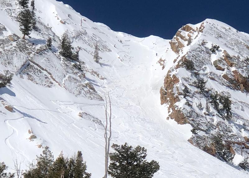
The mid and upper elevation steep northwest through easterly facing terrain has a MODERATE danger for triggering an avalanche 1-3' deep on one, perhaps two buried persistent weak layers.
A LOW danger exists on all other slopes. Normal Caution should be observed. Wet push-alanches possible in terrain that had a poor overnight refreeze. Dry sluffs and pockets of shallow new wind drifts up high.
Follow safe travel protocol, carry and know how to use your rescue gear, and minimize your exposure in high consequence terrain.
Low
Moderate
Considerable
High
Extreme
Learn how to read the forecast here
Special Announcements
When the forecasting ends, the UAC’s work keeps going strong. Summer is a busy time for the UAC. During the summer we are working hard on our fall and winter planning; putting together the Fall Fundraiser and the Utah Snow and Avalanche Workshop; updating our awareness and education programs; this summer we will be finishing up the website redesign project. Your donation shows you’re invested in this community all year round! You can still be part of the UAC’s success in 2019.
Weather and Snow
As of 5am, skies are mostly cloudy ahead of the advancing storm. Mountain temperatures along the higher elevations are back to or have exceeded yesterday's daytime highs of the upper 20s to low 30s. Mid-elevations have struggled to dip below freezing at all. Winds backed to the southwest overnight and are blowing 10-15mph with gusts to 25. A trace of rain or snow fell in some areas overnight.
For today, we'll see thickening clouds and a few inches of afternoon snow (2-4"?) with pulses of graupel and maybe a clap of thunder or two. Temps will still reach into the low 40s down low and the low 30s up high. The south to southwesterlies will blow 15-20mph with occasionally higher gusts in the afternoon. The failing heart of the storm passes through tomorrow morning and all told, we should see 4-8" of snow by midday Wednesday with an unsteady rain/snow line hovering between 7-7500'.
Recent Avalanches
A skier in the Snowbasin backcountry on Sunday triggered a wind slab in east-facing Mt. Ogden Chute at 9,400', breaking 14" deep and 30' wide (pic below). Two sets of ski tracks were taken out in the slide. Also on Sunday near Powder Mountain, an intentional ski cut on a north-northeast aspect at 8,200' released a 10" by 100' avalanche that traveled 500' on a knife hard melt freeze crust.
On Friday an avalanche was triggered on "Scrapies", a steep east-facing slope at 9,100'. Powder Mountain conducted an investigation of the avalanche involvement in their out of bounds terrain here. This is private property; see video below.
Ad
Avalanche Problem #1
Persistent Weak Layer
Type
Location
Likelihood
Size
Description
A two-week old buried weak layer still exists on protected mid and upper elevation northerly to easterly facing slopes. This is buried 1-3' deep and may be triggered at a distance. The last reported collapses was on Friday and was the culprit in a very close call on the 25th. In suspect terrain, a quick 2-3 foot pit could reveal the thin grey line or the alarming test result that keeps you out of harms way. Weak interfaces may also be found before this last storm at the mid and upper elevations (see Scrapey's avalanche). Extra caution is recommended in this suspect terrain. Obvious clues may not be present.
Photo: Buried weak layer in the Ogden mountains.
Additional Information
Good info can always be found on ogdenavalanche.org and Instagram
General Announcements
This information does not apply to developed ski areas or highways where avalanche control is normally done. This forecast is from the U.S.D.A. Forest Service, which is solely responsible for its content. This forecast describes general avalanche conditions and local variations always occur.