Forecast for the Ogden Area Mountains

Evelyn Lees
Issued by Evelyn Lees for
Wednesday, March 27, 2019
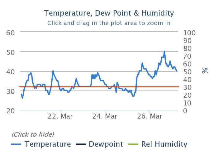
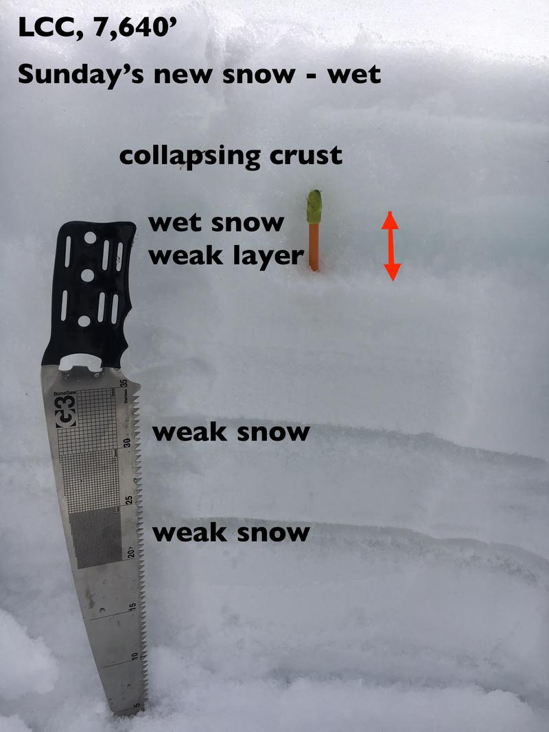
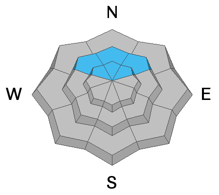
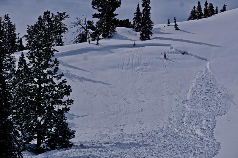
The avalanche danger is MODERATE for wet avalanches - both loose sluffs and shallow wet slab avalanches are possible in all steep terrain, except for the northerly upper elevations. The danger of wet snow avalanches will peak during the heat of the day or any periods of more direct sun, and may rise to CONSIDERABLE at the low elevations.
The avalanche danger is also MODERATE on steep mid and upper elevation slopes for triggering a slab of wind drifted snow or storm snow, possibly breaking on surface hoar or facets. These may be triggered at a distance.
Low
Moderate
Considerable
High
Extreme
Learn how to read the forecast here
Special Announcements
We need your help. In an effort to increase awareness and prevent future fatalities we need to reach more people with our daily avalanche forecasts, expand the Know Before You Go program, and increase the number of on-snow avalanche courses. Please consider a donation to the UAC to help us raise $25,000 by April 8. Help your support of the UAC by making a donation HERE. Thank you -
Weather and Snow
Under a blanket of high thin clouds, temperatures are in the low 40s at the mid and low elevations - too warm for comfort - with no overnight refreeze. The high ridge lines are in the low to mid 30s. The southerly winds are the cooling grace - averaging 10 to 20 mph, with gusts to 30 at the mid elevation stations, and the high ridge lines averaging 25 to 35, and gusting in the 40s. Speeds are forecast to remain in this range, and possibly increase a bit throughout the day. Temperatures should warm into the low 50s at the low and mid elevations, and mid 30s along the high ridge lines.
The wind are eating away at the remaining dry snow, so powder will be a scarce commodity today - any remnants will be on upper elevation, wind sheltered northerly facing slopes. Elsewhere, a challenging mix of breakable and supportable sun and wind crusts.
Recent Avalanches
Yesterday was less active than the day before - a few small slides were released by avalanche control teams on northeasterly facing slopes along the highest ridge lines. There were reports of wet, slushy snow at the lower elevations.
But it's not to forget avalanches were triggered on a faceted snow layer as recently as Friday and Monday, the 22nd and 25th. On Monday, near Perry Lake, a very experienced skier on the uptrack collapsed the slope (northeast facing at 8400') and triggered a 2' deep and 150' wide avalanche that failed on surface hoar buried last Thursday. It propagated a couple hundred feet above him and he was carried down and partially buried. He was not injured in the event. More details can be found HERE Picture below.
Ad
Avalanche Problem #1
Wet Snow
Type
Location
Likelihood
Size
Description
Winds and clouds won the battle yesterday, keeping the snow mostly cool, and I’m hoping the same combination will minimize the wet avalanche activity again today. Fighting on the other side are the warm temperatures, many mid and lower elevations stations have been above freezing for 48 hours, and the snowpack at these elevations will struggle with heating today. Below is a 7 day temperature graph from the Ben Lomond Snotel, 7,688'. ° F on the left axis, red line is 32° F
Wet loose sluffs are the simpler problem - when the surface snow gets damp, head to lower angle slopes and avoid travel in and below run out zones. Be especially alert for the snow to rapidly heat if the sun comes out, the clouds thin or the wind stops blowing where you are.
Wet Slabs are the tricky problem - this is when deeper layers of snow have remained wet, hiding beneath shallowly frozen crusts. Signs to watch for - collapsing, punchy or bending crusts, or when you are breaking through the crusts. A wet slab can break loose when you think you’re on a supportable frozen snow. Stopping to dig down just a foot or two can let you search for layers of weak, wet snow in the upper snowpack. Photo below is of the layering to be looking for.
Avalanche Problem #2
Persistent Weak Layer
Type
Location
Likelihood
Size
Description
Buried and preserved surface hoar and faceted, recrystallized snow - now 12-24" deep - may still be triggered in the shady terrain of the mid and upper elevations. Audible collapsing was noted prior to Monday's avalanche release. Collapsing and avalanches also occurred on this layering in the Cutler Ridge area on Friday. This layering should be viewed as suspect until proven otherwise and slopes should be assessed individually with conservative decision making always a good call.
Fortunately, this layering is easy to recognize and test with both compression and extended column tests. Collapsing and cracking are sure signs of instability. These may be triggered remotely. Add'l photo of Perry Reservoir area slide from Monday below -
Avalanche Problem #3
Wind Drifted Snow
Type
Location
Likelihood
Size
Description
Pockety wind drifts can be expected now primarily in the upper elevation northwest to north to east facing slopes. Most of Sunday's storm snow instabilities have settled out by now.
General Announcements
This information does not apply to developed ski areas or highways where avalanche control is normally done. This forecast is from the U.S.D.A. Forest Service, which is solely responsible for its content. This forecast describes general avalanche conditions and local variations always occur.