UDOT PLANNED AVALANCHE CLOSURES!!

Forecast for the Ogden Area Mountains

Drew Hardesty
Issued by Drew Hardesty for
Tuesday, March 26, 2019
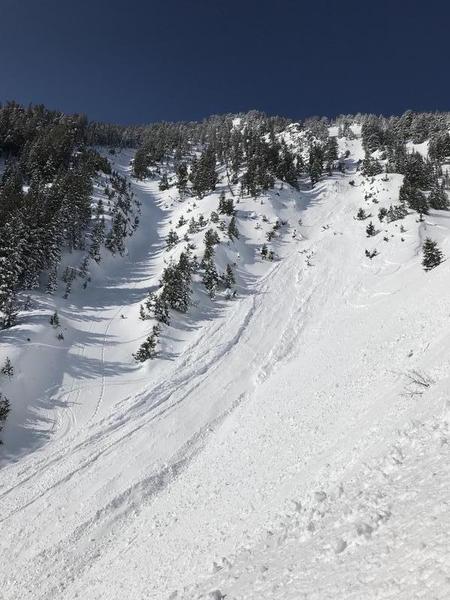
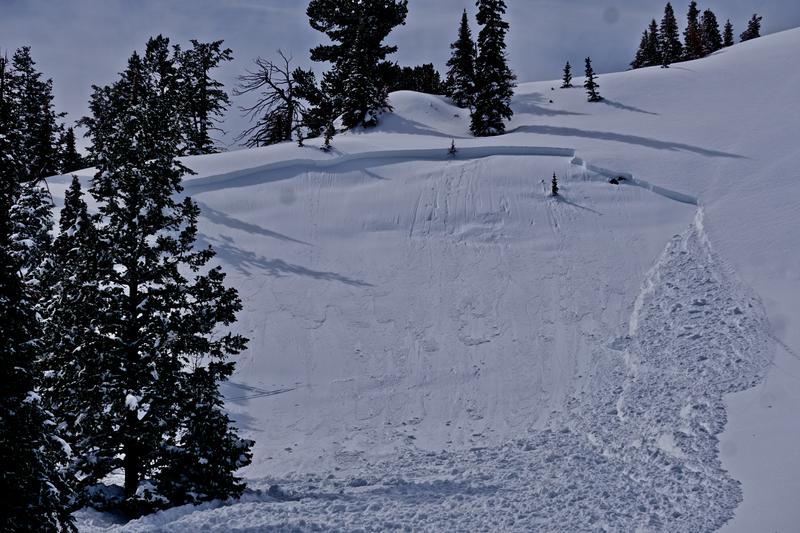
The avalanche danger rise earlier today to CONSIDERABLE for wet avalanches on all steep sunlit slopes with sun and warming.
Natural and human triggered wet avalanches are certain on east, then south, then west facing slopes...and even include low and some mid elevation northerly terrain. Human triggered soft slab avalanches are still possible in the northerly mid and upper elevations. These may be triggered at a distance.
Low
Moderate
Considerable
High
Extreme
Learn how to read the forecast here
Special Announcements
We need your help. In an effort to increase awareness and prevent future fatalities we need to reach more people with our daily avalanche forecasts, expand the Know Before You Go program, and increase the number of on-snow avalanche courses. Please consider a donation to the UAC to help us raise $25,000 by April 8. Help your support of the UAC by making a donation HERE. Thank you -
Weather and Snow
Skies are mostly clear but for some high cloud cover overhead. In the black of night, one could make out the moon-dog with these high streamers moving through. The south to southwesterlies picked up overnight and are blowing 15-20mph with gusts to 35. The anemometers along the Ogden skyline as well as James Peak have hourly averages of 25-35mph with gusts to 45. As of 4am, temperatures are already in the upper-30s and low 40s. Snow surfaces will soften and become unstable much earlier with this fair-at-best refreeze. Upper elevation northerlies held the last vestiges of good riding, but they'll now have suffered a bit of wind damage.

With the ridge axis now just to the east, we'll see high thin clouds, moderate southwest winds, and scorching temperatures in the mountains. Many trailheads and base areas are forecast to reach near 60°F with ridgelines heading toward 40°F. Scorching temperatures will persist through Wednesday night when a disorganized system ushers in cooler temps and perhaps a few inches of snow.
Recent Avalanches
Avalanche control teams triggered numerous new snow soft slabs at the mid and upper elevations yesterday along with lower elevation damp push-alanches running fast and far on the slick underlying crusts. A large, long running loose wet avalanche spilled out of one of the Hell's Canyon fingers of the Snowbasin periphery yesterday (pc-srflight). Farther to the north - along the upper North Fork and Paradise boundary near Perry Lake, a very experienced skier on the uptrack collapsed the slope (northeast facing at 8400') and triggered a 2' deep and 150' wide avalanche that failed on surface hoar buried last Thursday. It propagated a couple hundred feet above him and he was carried down and partially buried, losing some gear. He was not injured in the event. More details can be found HERE and on ogdenavalanche.org. 2nd pic below
You can always find good info at http://www.ogdenavalanche.org/ and on Instagram ogdenavalanche
Ad
Avalanche Problem #1
Wet Snow
Type
Location
Likelihood
Size
Description
Spring wet avalanching is affected by a ton of factors relating to cloud cover, relative humidity, temperature, wind, albedo; the list goes on and on. You see the scales above. Mitigating factors to potentially limit today's wet activity include the southwest wind and previous sun/temp damage. But for me, it's not enough. Today - owing to the warm overnight temps - the surface snow will thaw and become unstable much more quickly than yesterday. Natural and human triggered wet avalanche can again be expected in steep terrain on all but the steep northerly upper elevations. Much of the wet snow will be able to run fast and far on the underlying crusts and even potentially gouge into unconsolidated wet grains in the low elevation shady terrain.
Initial signs of instability include rollerballs, pinwheels, initially small sluffs. Finding yourself boot-top or trenching in the wet snow? These are signs to seek colder aspects or low angle terrain.
Timing is key. If you're reading this, you're probably too late to be on any steepest, most sustained slopes that'll see direct sun and heating. Plan your descents and exits accordingly.
Avalanche Problem #2
Persistent Weak Layer
Type
Location
Likelihood
Size
Description
Buried and preserved surface hoar and faceted, recrystallized snow - now 12-24" deep - may still be triggered in the shady terrain of the mid and upper elevations. It showed its hand yesterday. Audible collapsing was noted prior to the avalanche release. We found it active and collapsing on Saturday above about 7500' with avalanches also triggered on this layering in the Cutler Ridge area on Friday. This layering should be viewed as suspect until proven otherwise and slopes should be assessed individually with conservative decision making always a good call.
Fortunately, this layering is easy to recognize and test with both compression and extended column tests. Collapsing and cracking are sure signs of instability. These may be triggered remotely. Add'l photo of Perry Reservoir area slide from yesterday below -
Avalanche Problem #3
Wind Drifted Snow
Type
Location
Likelihood
Size
Description
Pockety wind drifts can be expected now primarily in the upper elevation northwest to north to northeast facing slopes. Most of Sunday's storm snow instabilities have settled out by now.
Additional Information
CORNICES will become more sensitive as they sag in the sweltering heat. These have become enormous this winter and destruction from cornice failure has been well observed and documented this week. INFO.
ROOF-ALANCHES are also expected with the sun and temperatures. PLEASE spread the word to other homeowners in the mountains. Roof-alanche fatalities have occurred in the West this year with many close calls.
General Announcements
This information does not apply to developed ski areas or highways where avalanche control is normally done. This forecast is from the U.S.D.A. Forest Service, which is solely responsible for its content. This forecast describes general avalanche conditions and local variations always occur.